
ملف:Enceladus PIA06191.jpg

الملف الأصلي (3٬750 × 2٬876 بكسل حجم الملف: 1٫05 ميجابايت، نوع MIME: image/jpeg)
| هذا ملف من ويكيميديا كومنز. معلومات من صفحة وصفه مبينة في الأسفل. كومنز مستودع ملفات ميديا ذو رخصة حرة. |
ملخص
| الوصف |
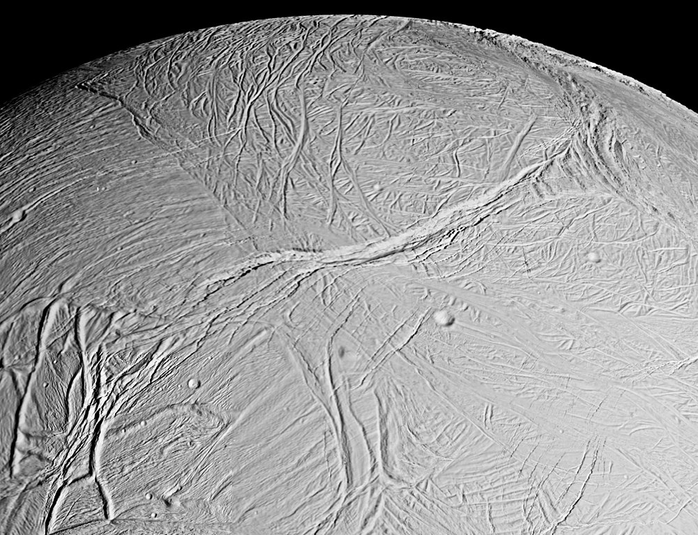
English: This spectacular view is a mosaic of four high resolution images taken by the Cassini spacecraft narrow angle camera on Feb. 16, 2005, during its close flyby of Saturn's moon Enceladus.
The view is about 300 kilometers (200 miles) across and shows the myriad of faults, fractures, folds, troughs and craters that make this Saturnian satellite especially intriguing to planetary scientists. More than 20 years ago, NASA's Voyager spacecraft gave hints of a surface cut by tectonic features, and subsequent images of other icy moons have revealed many different ways that stresses have acted on icy moon crusts. The new close-up images of Enceladus, which has a diameter of 505 kilometers (314 miles), show some familiar-looking features and others that are brand new. The work required to unravel their origins, their formation sequence, and the implications for the evolution of icy solar system bodies is just beginning. Voyager images of Enceladus, which were obtained at much poorer spatial resolution, showed terrains like those seen here. They were called "smooth plains" because they appeared to exhibit little topographic relief. However, Cassini has now viewed these terrains at almost 10 times better resolution. The new images reveal very complex systems of fractures, resurfaced terrain, and in some cases, topographic relief greater than several hundred meters. Many styles of fracturing are evident in this mosaic. Extending downward from the top center of the mosaic for hundreds of kilometers is a broad belt of complex, interwoven fractures. A huge rift 5 kilometers (3 miles)-wide dissects this belt and extends into several older-looking, distinct regions or "cells" of terrain that themselves exhibit distinct fracture patterns. Because Cassini flew rapidly past Enceladus, the right-side images were taken from a slightly different perspective than the left, and are delineated by the white box. The mosaic covers longitudes from about 254 west to 296 west and latitudes from 60 south to the equator. The images were taken in visible light on Feb. 17, 2005, at distances ranging from of 26,140 to 17,434 kilometers (16,243 to 10,833 miles) from Enceladus and at Sun-Enceladus-spacecraft, or phase, angles ranging from 27 to 29 degrees. Pixel scale in the left-side image is 150 meters (492 feet) per pixel; in the right-side (white box) image, scale is 105 meters (344 feet) per pixel. The image has been contrast-enhanced to aid visibility. |
| التاريخ | |
| المصدر | http://photojournal.jpl.nasa.gov/catalog/PIA06191 |
| المؤلف | NASA/JPL/Space Science Institute |
فُهرِست هذه الصُّورة أَو هذا التَّسجيل المرئي لدى مركز جونسون للفضاء التَّابعة لوكالة الفضاء الأَمريكيَّة (ناسا) تحت المُعرِّف PIA06191. لا يُشير هذه الوَسم إلى حالة حقوق التَّأليف والنَّشر الخاصَّة بالعمل المُرفَق؛ لا يزال وَسم حقوق التَّأليف والنَّشر مَطلُوباً، راجع كومنز:ترخيص لمزيدٍ من المعلومات. لغات أخرى:
|
ترخيص
| يقع هذا العمل في النِّطاق العامّ في الولايات المُتحدة الأمريكيَّة لأَنَّه عملٌ خالِصٌ من إِنتاج وكالة الفضاء الأمريكيَّة. تنصُ حقوق التَّأليف والنَّشر الخاصَّة بوكالة الفضاء الأمريكيَّة على أنَّ "أعمال الوكالة غير مَحميَّة بحقوق التَّأليف والنَّشر ما لم يُذكر خلافُ ذلك". لمزيدٍ من المعلومات انظر القالِب {{PD-USGov}} وصفحة حقوق التَّأليف والنَّشر الخاصَّة بالوكالة وصفحة سياسة الصُّور الخاصَّة بمُختبر الدَّفع النَّفَّاث. | ||
 |
تنبيهات:
|
تاريخ الملف
اضغط على زمن/تاريخ لرؤية الملف كما بدا في هذا الزمن.
| زمن/تاريخ | صورة مصغرة | الأبعاد | مستخدم | تعليق | |
|---|---|---|---|---|---|
| حالي | 22:54، 1 أبريل 2016 | | 3٬750 × 2٬876 (1٫05 ميجابايت) | Banjo | better res |
| 15:50، 20 فبراير 2005 |  | 2٬340 × 1٬580 (623 كيلوبايت) | Bricktop | Enceladus image from NASA |
استخدام الملف
الصفحة التالية تستخدم هذا الملف:
الاستخدام العالمي للملف
الويكيات الأخرى التالية تستخدم هذا الملف:
- الاستخدام في cs.wikipedia.org
- الاستخدام في da.wikipedia.org
- الاستخدام في de.wikipedia.org
- الاستخدام في en.wikipedia.org
- الاستخدام في en.wikinews.org
- الاستخدام في et.wikipedia.org
- الاستخدام في eu.wikipedia.org
- الاستخدام في gl.wikipedia.org
- الاستخدام في he.wikipedia.org
- الاستخدام في io.wikipedia.org
- الاستخدام في it.wikipedia.org
- الاستخدام في ja.wikipedia.org
- الاستخدام في lb.wikipedia.org
- الاستخدام في nl.wikipedia.org
- الاستخدام في pl.wikipedia.org
- الاستخدام في ro.wikipedia.org
- الاستخدام في ru.wikipedia.org
- الاستخدام في srn.wikipedia.org
- الاستخدام في sv.wikinews.org
- الاستخدام في uk.wikipedia.org
- الاستخدام في uz.wikipedia.org
- الاستخدام في www.wikidata.org
- الاستخدام في zh.wikipedia.org