
ملف:ISS-33 Nighttime view of Qatar.jpg

حجم هذه المعاينة: 800 × 532 بكسل. الأبعاد الأخرى: 320 × 213 بكسل | 640 × 426 بكسل | 1٬024 × 681 بكسل | 1٬280 × 852 بكسل | 2٬560 × 1٬703 بكسل | 4٬256 × 2٬832 بكسل.
الملف الأصلي (4٬256 × 2٬832 بكسل حجم الملف: 941 كيلوبايت، نوع MIME: image/jpeg)
| هذا ملف من ويكيميديا كومنز. معلومات من صفحة وصفه مبينة في الأسفل. كومنز مستودع ملفات ميديا ذو رخصة حرة. |
ملخص
| الوصف |
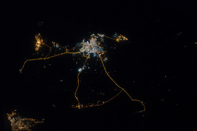
English: A nighttime view of Qatar is featured in this image photographed by an Expedition 33 crew member on the International Space Station.
|
| التاريخ | |
| المصدر | http://spaceflight.nasa.gov/gallery/images/station/crew-33/html/iss033e014856.html |
| المؤلف | NASA |
فُهرِست هذه الصُّورة أَو هذا التَّسجيل المرئي لدى مركز جونسون للفضاء التَّابعة لوكالة الفضاء الأَمريكيَّة (ناسا) تحت المُعرِّف ISS033-E-014856. لا يُشير هذه الوَسم إلى حالة حقوق التَّأليف والنَّشر الخاصَّة بالعمل المُرفَق؛ لا يزال وَسم حقوق التَّأليف والنَّشر مَطلُوباً، راجع كومنز:ترخيص لمزيدٍ من المعلومات. لغات أخرى:
|
ترخيص
يقع هذا الملفُّ في النِّطاق العامِّ في الولايات المُتحدة لأنَّه أُنشِئ مِن قبل مُختبر علوم الصُّور وتحليلها في مركز جُونسُون للفضاء التَّابِع لوَكالة الفضاء الأَمريكيَّة. تنصُّ سياسة حقوق التَّأليف والنَّشر لوَكالة الفضاء الأَمريكيَّة على أنَّ "المواد الَّتي تُنتجها الوَكالة غير مَحميَّةٍ بحقوق التَّأليف والنَّشر ما لم يُذكر خلاف ذلك". انظر (دليل استعمال الوسائِط الخاصِّ بالوَكالة أو شروط استعمال الصُّور الضُّوئِيَّة التي التقطها روَّاد الفضاء).
مَصدَر الصُّورة: ISS033-E-14856.
|
تاريخ الملف
اضغط على زمن/تاريخ لرؤية الملف كما بدا في هذا الزمن.
| زمن/تاريخ | صورة مصغرة | الأبعاد | مستخدم | تعليق | |
|---|---|---|---|---|---|
| حالي | 02:44، 15 نوفمبر 2012 | | 4٬256 × 2٬832 (941 كيلوبايت) | Ras67 | {{Information |Description={{en|1=A nighttime view of Qatar is featured in this image photographed by an Expedition 33 crew member on the International Space Station. * Night lights can be very revealing regarding the distribution of people on the land... |
استخدام الملف
لا توجد صفحات تستخدم هذا الملف.