
ملف:Manaus-Amazon-NASA.jpg
حجم هذه المعاينة: 600 × 600 بكسل. الأبعاد الأخرى: 240 × 240 بكسل | 480 × 480 بكسل | 768 × 768 بكسل | 1٬024 × 1٬024 بكسل | 2٬048 × 2٬048 بكسل | 5٬312 × 5٬312 بكسل.
الملف الأصلي (5٬312 × 5٬312 بكسل حجم الملف: 8٫7 ميجابايت، نوع MIME: image/jpeg)
| هذا ملف من ويكيميديا كومنز. معلومات من صفحة وصفه مبينة في الأسفل. كومنز مستودع ملفات ميديا ذو رخصة حرة. |
ملخص
Descrption
نُقِلت من en.wikipedia إلى كُومُنز .
صفحة الوصف الأصلية كانت هنا، تشير جميع أسماء المستخدمين التالية إلى en.wikipedia.
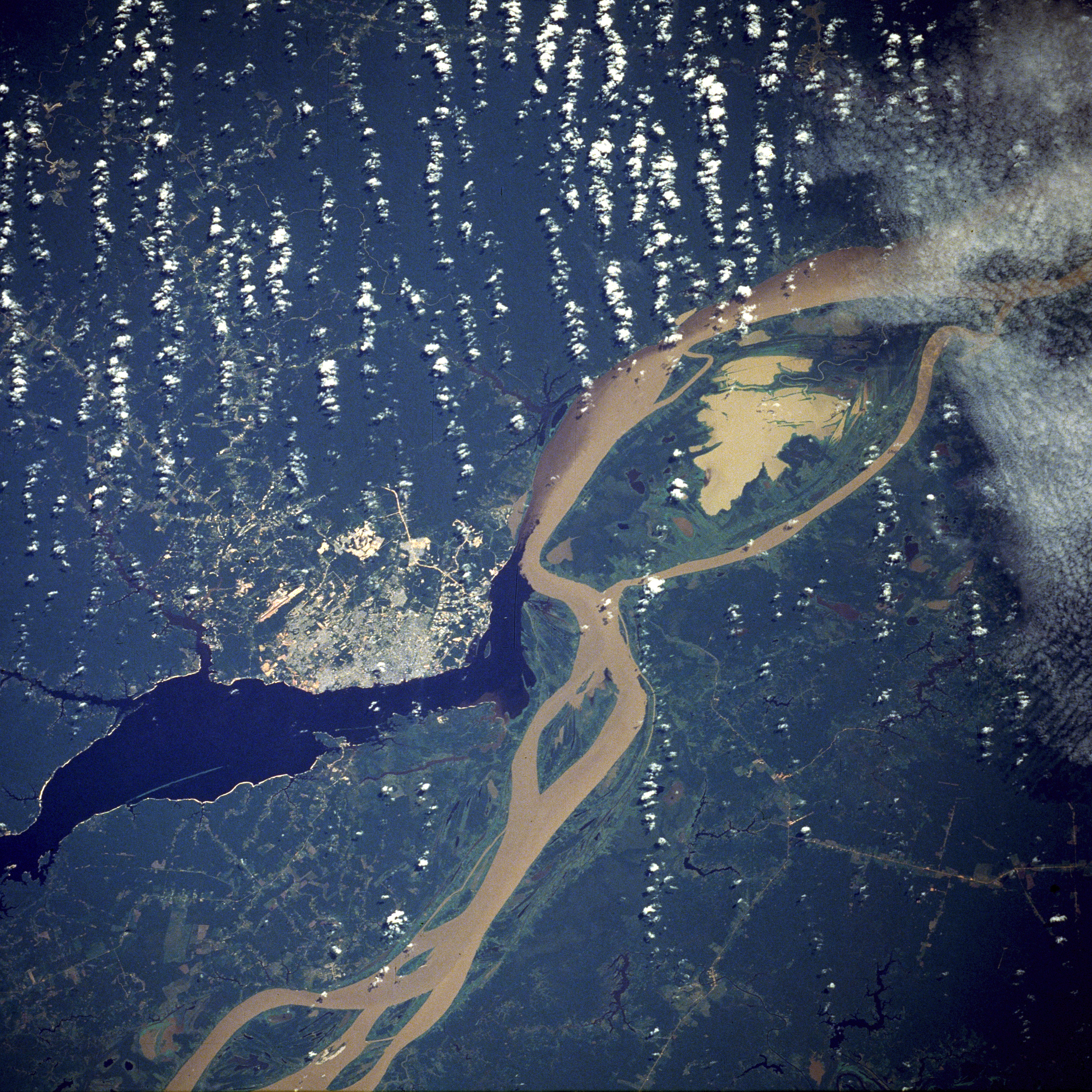
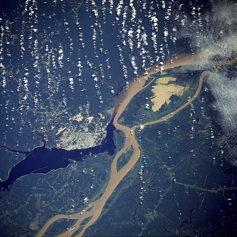
English: A satellite image of the city of Manaus with surrounding rivers.
English: Original caption:
- STS61C-33-84 Manaus, Amazonas, Brazil January 1986
- Two rivers and an urban area dominate this photograph. The largest city in the Amazon Basin, Manaus (with a 1994 population of 1.7 million), is located at the confluence of the Rio Negro (dark blue) and the Amazon River (lighter because of its high sediment content). The combined river flows eastward into the Atlantic Ocean. Situated approximately 800 miles (1290 kilometers) from the mouth of the Amazon River but accessible to oceangoing ships, Manaus is an important river port. This port city started to flourish in the late 1800s when the rubber boom was at its peak. Rubber, Brazil nuts, lumber, and assorted fruits are exported. In recent years, renewed interest in general development and the discovery of oil and manganese near Manaus have brought new importance to the city. A number of highways (linear, light-colored features), as well as a large commercial airport north of the city, are visible in the rain forest north and south of Manaus. North-south ground transportation is hindered because no bridges cross the Rio Negro or Amazon River. A large, sediment-laden lake (note irregular shoreline) is located east of Manaus between the main channel of the Amazon River and a smaller channel to the south.
Source
http://earth.jsc.nasa.gov/sseop/EFS/photoinfo.pl?PHOTO=STS61C-33-84 (file)
English: Photo credit: NASA
فُهرِست هذه الصُّورة أَو هذا التَّسجيل المرئي لدى وهو أحد المراكز التَّابعة لوكالة الفضاء الأَمريكيَّة (ناسا) تحت المُعرِّف STS61C-33-84. لا يُشير هذه الوَسم إلى حالة حقوق التَّأليف والنَّشر الخاصَّة بالعمل المُرفَق؛ لا يزال وَسم حقوق التَّأليف والنَّشر مَطلُوباً، راجع كومنز:ترخيص لمزيدٍ من المعلومات. لغات أخرى:
|
English-Wikipedia:
| date/time | username | edit summary |
|---|---|---|
| 10:52, 14 December 2004 | en:User:Magnus Manske | ({{PD-USGov-NASA}}) |
| 18:15, 18 June 2004 | en:User:Sverdrup | (Image info) |
| 18:14, 18 June 2004 | en:User:Sverdrup | (A satellite image of the city of <a href="/wiki/Manaus" title="Manaus">Manaus</a> with surrounding rivers.) |
Other version: Image:Manaus-Amazon-NASA2.jpg
See also

ترخيص
| يقع هذا العمل في النِّطاق العامّ في الولايات المُتحدة الأمريكيَّة لأَنَّه عملٌ خالِصٌ من إِنتاج وكالة الفضاء الأمريكيَّة. تنصُ حقوق التَّأليف والنَّشر الخاصَّة بوكالة الفضاء الأمريكيَّة على أنَّ "أعمال الوكالة غير مَحميَّة بحقوق التَّأليف والنَّشر ما لم يُذكر خلافُ ذلك". لمزيدٍ من المعلومات انظر القالِب {{PD-USGov}} وصفحة حقوق التَّأليف والنَّشر الخاصَّة بالوكالة وصفحة سياسة الصُّور الخاصَّة بمُختبر الدَّفع النَّفَّاث. | ||
 |
تنبيهات:
|
| الشروح | هذه الصورة مشروحة: أظهر الشروح في كومنز |
تاريخ الملف
اضغط على زمن/تاريخ لرؤية الملف كما بدا في هذا الزمن.
| زمن/تاريخ | صورة مصغرة | الأبعاد | مستخدم | تعليق | |
|---|---|---|---|---|---|
| حالي | 05:17، 20 نوفمبر 2011 | | 5٬312 × 5٬312 (8٫7 ميجابايت) | Delirium | much higher-resolution version from the same source |
| 04:38، 9 نوفمبر 2011 |  | 640 × 640 (262 كيلوبايت) | Creysmon07 | Corrected the contrast to a more realistic. | |
| 14:41، 29 يناير 2006 |  | 640 × 640 (157 كيلوبايت) | Maksim | La bildo estas kopiita de wikipedia:en. La originala priskribo estas: A satellite image of the city of Manaus with surrounding rivers. '''Original caption:''' :''STS61C-33-84 Manaus, Amazonas, Brazil January 1986'' :''Two rivers and an urban area d |
استخدام الملف
الصفحتان التاليتان تستخدمان هذا الملف:
الاستخدام العالمي للملف
الويكيات الأخرى التالية تستخدم هذا الملف:
- الاستخدام في azb.wikipedia.org
- الاستخدام في be.wikipedia.org
- الاستخدام في bo.wikipedia.org
- الاستخدام في ce.wikipedia.org
- الاستخدام في cs.wikipedia.org
- الاستخدام في de.wikipedia.org
- الاستخدام في de.wikinews.org
- الاستخدام في en.wikipedia.org
- الاستخدام في en.wikinews.org
- الاستخدام في eo.wikipedia.org
- الاستخدام في et.wikipedia.org
- الاستخدام في fa.wikipedia.org
- الاستخدام في fi.wikipedia.org
- الاستخدام في fr.wikipedia.org
- الاستخدام في hr.wikipedia.org
- الاستخدام في id.wikipedia.org
- الاستخدام في ja.wikipedia.org
- الاستخدام في li.wikipedia.org
- الاستخدام في ml.wikipedia.org
- الاستخدام في nl.wikipedia.org
- الاستخدام في no.wikipedia.org
- الاستخدام في pt.wikipedia.org
- الاستخدام في ro.wikipedia.org
- الاستخدام في ru.wikipedia.org
- الاستخدام في sv.wikipedia.org
- الاستخدام في uk.wikipedia.org
- الاستخدام في ur.wikipedia.org
- الاستخدام في www.wikidata.org
- الاستخدام في zh-yue.wikipedia.org
- الاستخدام في zh.wikipedia.org