
ملف:PeloponnesosMap.png

الملف الأصلي (330 × 653 بكسل حجم الملف: 67 كيلوبايت، نوع MIME: image/png)
| هذا ملف من ويكيميديا كومنز. معلومات من صفحة وصفه مبينة في الأسفل. كومنز مستودع ملفات ميديا ذو رخصة حرة. |
This image was copied from wikipedia:en. The original description was:
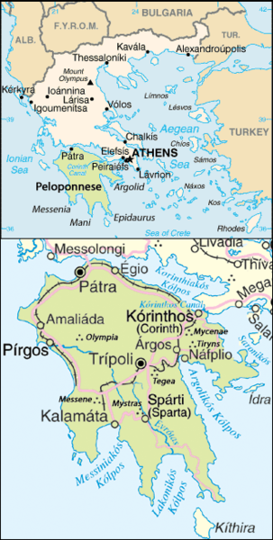
Map of the Peloponnesos.
Adapted from http://www.un.org/Depts/Cartographic/map/profile/greece.pdf
| هذا عملٌ لموظَّفٍ في وكالة الاستخبارات المركزيَّة، اُلتقِط أو صُنِع في أثناء أدائِه لواجباته الرَّسميَّة. بصفته عملاً مِن أعمال الحكومة الاتحاديَّة للولايات المُتَّحدة الأمريكيَّة، فإِنَّ هذه الصُّورة تقع في النِّطاق العامِّ.
|

|
| This image is a map derived from a United Nations map.
Unless stated otherwise, UN maps are to be considered in the public domain. This applies worldwide. UN maps are, in principle, open source material and you can use them in your work or for making your own map. UN requests however that you delete the UN name, logo and reference number upon any modification to the map. Content of your map will be your responsibility. You can state in your publication, if you wish, something like: based on UN map … (map name, map number, revision number and date). See: Geospatial Information Section. And: Geospatial, location data for a better world. |
 |
| date/time | username | edit summary |
|---|---|---|
| 22:08, 25 June 2005 | ChrisO | |
| 22:07, 25 June 2005 | ChrisO | |
| 22:03, 25 June 2005 | ChrisO | (Map of the <a href="/wiki/Peloponnesos" title="Peloponnesos">Peloponnesos</a>. Adapted from www.un.org/Depts/Cartographic/map/profile/greece.pdf {{PD-USGov-CIA}} {{UN-map}}) |
تاريخ الملف
اضغط على زمن/تاريخ لرؤية الملف كما بدا في هذا الزمن.
| زمن/تاريخ | صورة مصغرة | الأبعاد | مستخدم | تعليق | |
|---|---|---|---|---|---|
| حالي | 22:26، 25 أكتوبر 2017 | | 330 × 653 (67 كيلوبايت) | Peritios | Reverted to version as of 23:41, 24 October 2017 (UTC) |
| 07:58، 25 أكتوبر 2017 |  | 330 × 653 (152 كيلوبايت) | MacedonianBoy | Reverted to version as of 08:59, 20 October 2013 (UTC) | |
| 23:41، 24 أكتوبر 2017 |  | 330 × 653 (67 كيلوبايت) | Peritios | Reverted to version as of 20:28, 8 October 2005 (UTC) | |
| 20:44، 3 أغسطس 2014 |  | 328 × 650 (51 كيلوبايت) | Ras67 | cropped | |
| 08:59، 20 أكتوبر 2013 |  | 330 × 653 (152 كيلوبايت) | MacedonianBoy | name change | |
| 20:28، 8 أكتوبر 2005 |  | 330 × 653 (67 كيلوبايت) | ChongDae | This image was copied from wikipedia:en. The original description was: Map of the Peloponnesos. Adapted from http://www.un.org/Depts/Cartographic/map/profile/greece.pdf {{PD-USGov-CIA}} {{UN map}} {| border="1" ! date/time || username || edit sum |
استخدام الملف
الصفحة التالية تستخدم هذا الملف:
الاستخدام العالمي للملف
الويكيات الأخرى التالية تستخدم هذا الملف:
- الاستخدام في af.wikipedia.org
- الاستخدام في br.wikipedia.org
- الاستخدام في cs.wikipedia.org
- الاستخدام في en.wikipedia.org
- الاستخدام في fa.wikipedia.org
- الاستخدام في fo.wikipedia.org
- الاستخدام في hi.wikipedia.org
- الاستخدام في hu.wikipedia.org
- الاستخدام في incubator.wikimedia.org
- الاستخدام في ka.wikipedia.org
- الاستخدام في ko.wikipedia.org
- الاستخدام في lt.wikipedia.org
- الاستخدام في nn.wikipedia.org
- الاستخدام في no.wikipedia.org
- الاستخدام في ro.wikipedia.org
- الاستخدام في rue.wikipedia.org
- الاستخدام في sh.wikipedia.org
- الاستخدام في sl.wikipedia.org
- الاستخدام في sr.wikipedia.org
- الاستخدام في tr.wikipedia.org