
ملف:PonticKingdom.png

حجم هذه المعاينة: 718 × 600 بكسل. الأبعاد الأخرى: 287 × 240 بكسل | 575 × 480 بكسل | 919 × 768 بكسل | 1٬226 × 1٬024 بكسل | 1٬551 × 1٬296 بكسل.
الملف الأصلي (1٬551 × 1٬296 بكسل حجم الملف: 265 كيلوبايت، نوع MIME: image/png)
| هذا ملف من ويكيميديا كومنز. معلومات من صفحة وصفه مبينة في الأسفل. كومنز مستودع ملفات ميديا ذو رخصة حرة. |

|
هذه historical map الصورة / الصورتان باستعمال رسومات متجهية ملفات رسوميات شعاعية.
It is recommended to name the SVG file "PonticKingdom.svg" - then the template Vector version available (or Vva) does not need the new image name parameter.
|
| الوصف |
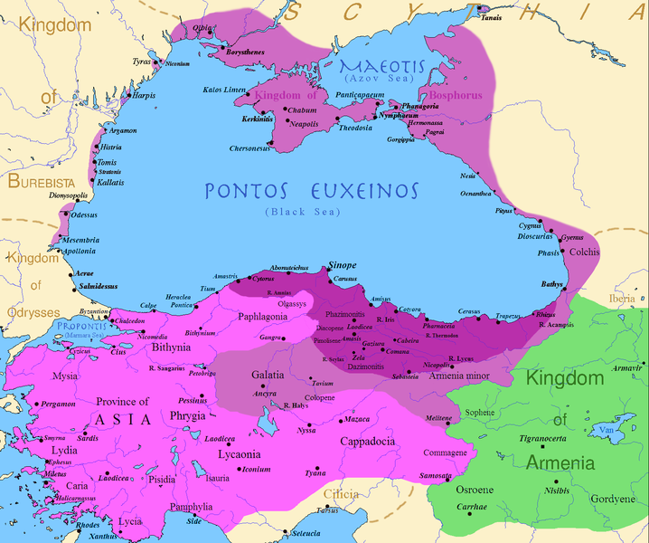
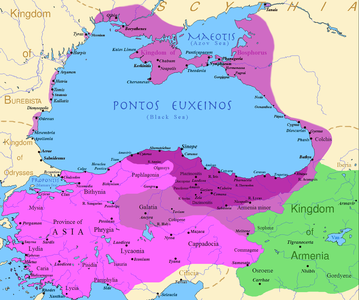
English: Map of the Kingdom of Pontus, Before the reign of Mithridates VI (darkest purple), after his conquests (purple), and his conquests in the first Mithridatic wars (pink); little adds (ancient shorelines & some greek colonies under Mithridate's rule) according with V. Yanko-Hombach, A.S. Gilbert, N. Panin, P. M. Dolukhanov: The Black Sea Flood Question: Changes in Coastline, Climate, and Human Settlement, Springer, Netherlands, 2007, and with Appianus, Plutarchus & Strabo. |
| التاريخ | |
| المصدر | I (Javierfv1212 (talk)) created this work entirely by myself. Sources, Cambridge Ancient history volume 9, Penguin atlas of Greek history and the Foreign Policy of Mithridates VI Eupator. |
| المؤلف | Javierfv1212 (talk) |
ترخيص
| وضع -Javierfv1212 في ويكيبيديا الإنجليزية-، وهو المؤلف، هذا العمل في النِّطاق العامِّ. يسري ذلك في كل أرجاء العالم. في بعض البلدان، قد يكون هذا التَّرخيص غيرَ مُمكنٍ قانونيَّاً، في هذه الحالة: يمنح Javierfv1212 الجميع حق استخدام هذا العمل لأي غرض دون أي شرط ما لم يفرض القانون شروطًا إضافية. |
سجلُّ الرَّفع الأصيل
نُقِلت من en.wikipedia إلى كُومُنز بواسطة Falcorian باستخدام CommonsHelper.
صفحة الوصف الأصلية كانت هنا، تشير جميع أسماء المستخدمين التالية إلى en.wikipedia.
- 2009-07-19 23:42 Javierfv1212 1551×1296× (205182 bytes) {{Information |Description = Map of the Kingdom of Pontus, Before the reign of mithridates VI (darkest purple), after his conquests (purple), and his conquests in the first Mithridatic wars (pink). |Source = I (~~~) created this work entirel
تاريخ الملف
اضغط على زمن/تاريخ لرؤية الملف كما بدا في هذا الزمن.
| زمن/تاريخ | صورة مصغرة | الأبعاد | مستخدم | تعليق | |
|---|---|---|---|---|---|
| حالي | 02:00، 9 ديسمبر 2017 | | 1٬551 × 1٬296 (265 كيلوبايت) | SteinsplitterBot | Bot: Image rotated by 90° |
| 00:00، 9 ديسمبر 2017 |  | 1٬296 × 1٬551 (316 كيلوبايت) | SteinsplitterBot | Bot: Image rotated by 270° | |
| 17:54، 22 سبتمبر 2016 |  | 1٬551 × 1٬296 (265 كيلوبايت) | Hohum | Lighten water area | |
| 11:21، 9 أغسطس 2016 |  | 1٬551 × 1٬296 (260 كيلوبايت) | MAXHO | Details : more cities & shoreline of this time | |
| 20:57، 1 أكتوبر 2015 |  | 1٬551 × 1٬296 (249 كيلوبايت) | Spiridon Ion Cepleanu | Cosmetic again | |
| 12:55، 30 سبتمبر 2015 |  | 1٬551 × 1٬296 (247 كيلوبايت) | Spiridon Ion Cepleanu | Cosmetic colours & background names | |
| 14:21، 7 أبريل 2014 |  | 1٬551 × 1٬296 (225 كيلوبايت) | Spiridon Ion Cepleanu | Little changes (ancient shoreline & some greek colonies under Pontic rule) according with V. Yanko-Hombach, A.S. Gilbert, N. Panin, P. M. Dolukhanov: ''The Black Sea Flood Question: Changes in Coastline, Climate, and Human Settlement'', Springer, Nethe... | |
| 04:14، 20 يوليو 2009 |  | 1٬551 × 1٬296 (200 كيلوبايت) | File Upload Bot (Magnus Manske) | {{BotMoveToCommons|en.wikipedia|year={{subst:CURRENTYEAR}}|month={{subst:CURRENTMONTHNAME}}|day={{subst:CURRENTDAY}}}} {{Information |Description={{en|Map of the Kingdom of Pontus, Before the reign of mithridates VI (darkest purple), after his conquests |
استخدام الملف
ال3 صفحات التالية تستخدم هذا الملف:
الاستخدام العالمي للملف
الويكيات الأخرى التالية تستخدم هذا الملف:
- الاستخدام في ast.wikipedia.org
- الاستخدام في azb.wikipedia.org
- الاستخدام في az.wikipedia.org
- الاستخدام في bg.wikipedia.org
- الاستخدام في br.wikipedia.org
- الاستخدام في ca.wikipedia.org
- الاستخدام في cs.wikipedia.org
- الاستخدام في da.wikipedia.org
- الاستخدام في de.wikipedia.org
- الاستخدام في el.wikipedia.org
- الاستخدام في en.wikipedia.org
- الاستخدام في es.wikipedia.org
- الاستخدام في et.wikipedia.org
- الاستخدام في eu.wikipedia.org
- الاستخدام في fa.wikipedia.org
- الاستخدام في fr.wikipedia.org
- الاستخدام في gl.wikipedia.org
اعرض المزيد من الاستخدام العام لهذا الملف.