
ملف:Sarajevo Grbavica.JPG
الملف الأصلي (2٬900 × 1٬860 بكسل حجم الملف: 3٫9 ميجابايت، نوع MIME: image/jpeg)
| هذا ملف من ويكيميديا كومنز. معلومات من صفحة وصفه مبينة في الأسفل. كومنز مستودع ملفات ميديا ذو رخصة حرة. |
ملخص
| الوصف |
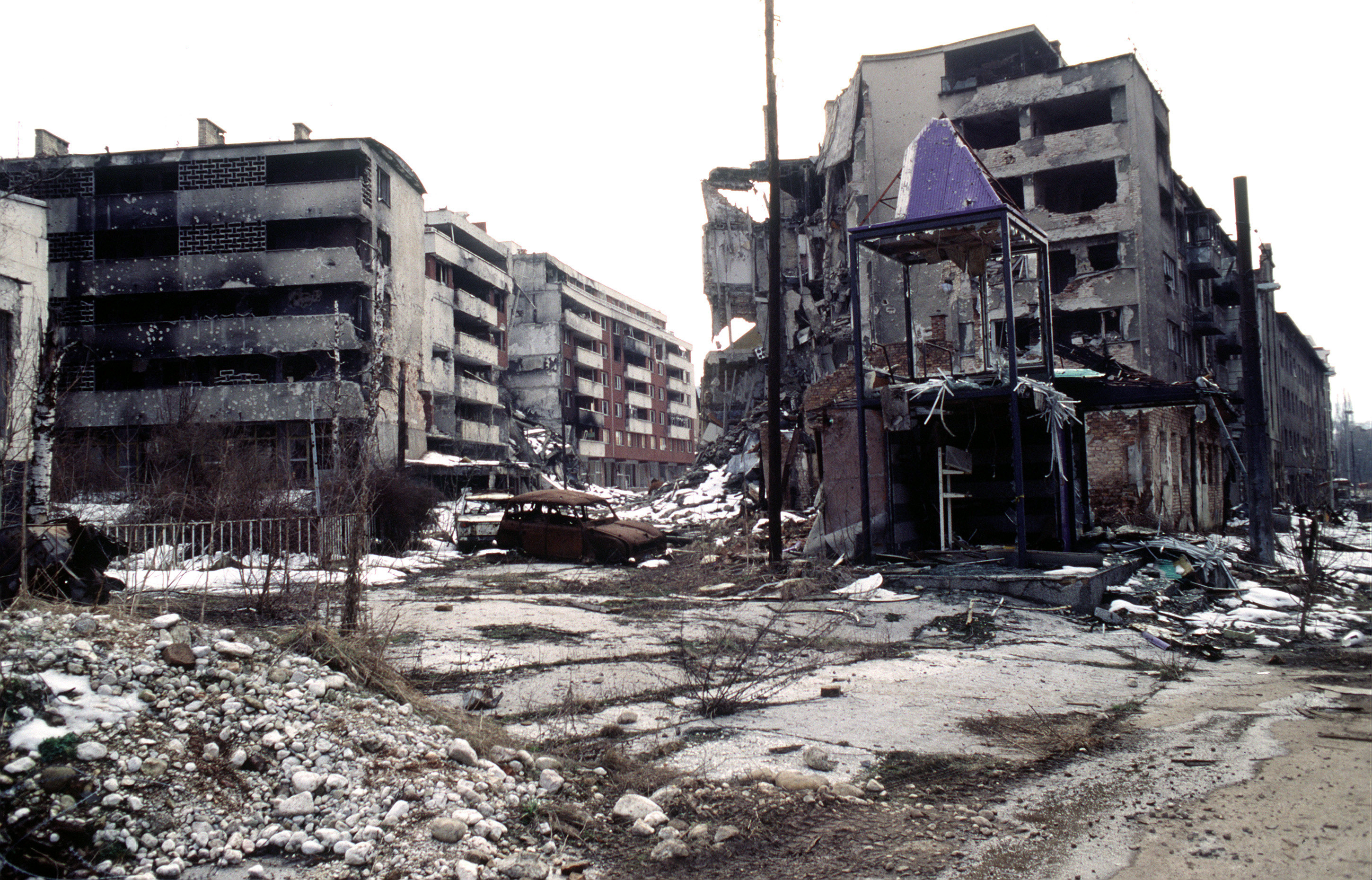
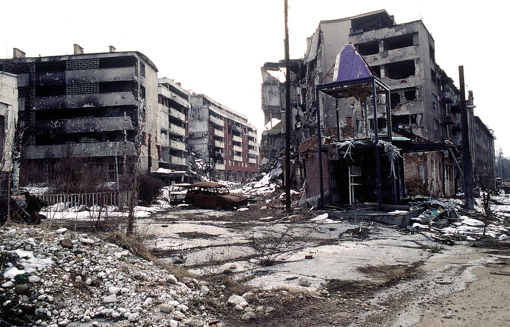
View of Grbavica, a neighbourhood of Sarajevo, approximately 4 months after the signing of the Dayton Peace Accord that officially ended the war in Bosnia. This particular scene shows the part of the neighbourhood located by the left bank of Miljacka river near Vrbanja bridge at the point where Zagrebačka Street and Beogradska Street (later renamed Emerika Bluma Street) meet. Throughout the war (1992-1995), Grbavica was held by the forces of Bosnian Serbs. In relation to the part of Grbavica shown in the photo, Bosnian Muslim (Bosniak) lines were right across on the Miljacka river's right bank. Due to its location in the crossfire between two sides, this part of Grbavica was exposed to constant fire and as a result suffered heavy structural damage. It was basically uninhabitable throughout the war - most of the apartments in the buildings seen in the photo were empty during the war as their occupants fled early on fearing for their safety. These ruins of the apartments and houses were among the last group to be turned over by the Bosnian Serbs to the Bosniaks (a.k.a. Bosnian Muslims) as required by the Dayton Peace Accord, which produced a lasting cease fire and permanent internal borders between two entities - Republika Srpska (Serb entity) and Federation of Bosnia-Herzegovina (Muslim-Croat entity). The white building whose small part (corner) can be seen along the photo's left edge housed the state-owned Unioninvest company before the war. In the years after the war ended, the partially devastated building was rebuilt and to this day houses the Office of the High Representative (OHR), an ad hoc international institution responsible for overseeing implementation of the Dayton Peace Accord (in essence, OHR is Bosnia's highest decision-making institutional body with broad powers). |
| التاريخ | |
| المصدر | www.dodmedia.osd.mil |
| المؤلف | LT. STACEY WYZKOWSKI |
| الترخيص (إعادة استخدام هذا الملف) |
Public Domain (PD-USGov-Military) |
| موقع الكاميرا | | هذه وغيرها من الصور في مواقعها على: خريطة الشارع المفتوحة |
|---|
ترخيص
هذه الصُّورة عملٌ لجنديٍّ أمريكيٍّ أو لموظفٍ لوزارة الدفاع، التقطت أو أُنشئت بصفتها جزءاً مِن واجباته الرَّسميَّة. ولأنَّها عملٌ من أَعمال الحكومة الاتحادية للولايات المُتحدة الأمريكيَّة فهي تقع في النِّطاق العامِّ فيها.
|
 |
تاريخ الملف
اضغط على زمن/تاريخ لرؤية الملف كما بدا في هذا الزمن.
| زمن/تاريخ | صورة مصغرة | الأبعاد | مستخدم | تعليق | |
|---|---|---|---|---|---|
| حالي | 21:02، 7 أبريل 2009 | | 2٬900 × 1٬860 (3٫9 ميجابايت) | PRODUCER | contrast |
| 14:37، 23 مارس 2008 |  | 2٬900 × 1٬860 (2٫14 ميجابايت) | ¡0-8-15! | ||
| 22:00، 20 نوفمبر 2006 |  | 640 × 410 (60 كيلوبايت) | Bunker~commonswiki | == Summary == {{Information |Description=Overall view of downtown Grbavica, a suburb of Sarajevo. These apartments and houses once occupied by Bosnia Serbs are the last group to be turned over to the Muslims as required by the recent Dayton Peace Accord w |
استخدام الملف
ال5 صفحات التالية تستخدم هذا الملف:
الاستخدام العالمي للملف
الويكيات الأخرى التالية تستخدم هذا الملف:
- الاستخدام في als.wikipedia.org
- الاستخدام في azb.wikipedia.org
- الاستخدام في be.wikipedia.org
- الاستخدام في bg.wikipedia.org
- الاستخدام في bs.wikipedia.org
- الاستخدام في ca.wikipedia.org
- الاستخدام في cs.wikipedia.org
- الاستخدام في de.wikipedia.org
- الاستخدام في el.wikipedia.org
- الاستخدام في en.wikipedia.org
- الاستخدام في en.wikinews.org
- الاستخدام في en.wikiquote.org
- الاستخدام في eo.wikipedia.org
- الاستخدام في es.wikipedia.org
- الاستخدام في eu.wikipedia.org
- الاستخدام في fa.wikipedia.org
- الاستخدام في fr.wikipedia.org
- الاستخدام في he.wikipedia.org
- الاستخدام في hr.wikipedia.org
- الاستخدام في hu.wikipedia.org
- الاستخدام في id.wikipedia.org
- الاستخدام في it.wikipedia.org
- الاستخدام في it.wikiquote.org
- الاستخدام في ja.wikipedia.org
- الاستخدام في ka.wikipedia.org
- الاستخدام في ko.wikipedia.org
اعرض المزيد من الاستخدام العام لهذا الملف.