
ملف:Vancouver Island NASA.png
لا توجد دقة أعلى متوفرة.
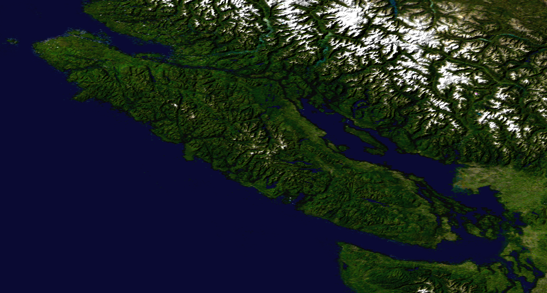
Vancouver_Island_NASA.png (792 × 424 بكسل حجم الملف: 485 كيلوبايت، نوع MIME: image/png)
| هذا ملف من ويكيميديا كومنز. معلومات من صفحة وصفه مبينة في الأسفل. كومنز مستودع ملفات ميديا ذو رخصة حرة. |
ملخص
| الوصف | Satellite composition of the whole Earth's surface. |
| التاريخ | image released 11. Feb. 2002 |
| المصدر |
Satellite composition of the whole Earth's surface. NASA - Visible Earth, image cropped by HighInBC |
| المؤلف | NASA/Goddard Space Flight Center |
| الترخيص (إعادة استخدام هذا الملف) |
Copyright information from http://visibleearth.nasa.gov/useterms.php - With the exception of images produced by the SeaWiFS, QuickBird, and IKONOS instruments all images on the Visible Earth are governed by NASA's Terms of Use below. [...] For all non-private uses, NASA's Terms Of Use are as follows: 1. The imagery is free of licensing fees 2. NASA requires that they be provided a credit as the owners of the imagery [...] |
ترخيص
| يقع هذا العمل في النِّطاق العامّ في الولايات المُتحدة الأمريكيَّة لأَنَّه عملٌ خالِصٌ من إِنتاج وكالة الفضاء الأمريكيَّة. تنصُ حقوق التَّأليف والنَّشر الخاصَّة بوكالة الفضاء الأمريكيَّة على أنَّ "أعمال الوكالة غير مَحميَّة بحقوق التَّأليف والنَّشر ما لم يُذكر خلافُ ذلك". لمزيدٍ من المعلومات انظر القالِب {{PD-USGov}} وصفحة حقوق التَّأليف والنَّشر الخاصَّة بالوكالة وصفحة سياسة الصُّور الخاصَّة بمُختبر الدَّفع النَّفَّاث. | ||
 |
تنبيهات:
|
تاريخ الملف
اضغط على زمن/تاريخ لرؤية الملف كما بدا في هذا الزمن.
| زمن/تاريخ | صورة مصغرة | الأبعاد | مستخدم | تعليق | |
|---|---|---|---|---|---|
| حالي | 14:24، 6 أغسطس 2007 | | 792 × 424 (485 كيلوبايت) | Jonesy22 | {{Information |Description= Satellite composition of the whole Earth's surface. |Source= Satellite composition of the whole Earth's surface. |Source = NASA - Visible Earth, image cropped by HighInBC * [http://visibleearth.nasa.gov/view_r |
استخدام الملف
الصفحة التالية تستخدم هذا الملف:
الاستخدام العالمي للملف
الويكيات الأخرى التالية تستخدم هذا الملف:
- الاستخدام في cs.wikipedia.org
- الاستخدام في sk.wikipedia.org