
ملف:1652 Sanson Map of India - Geographicus - India-sanson-1652.jpg

حجم هذه المعاينة: 762 × 599 بكسل. الأبعاد الأخرى: 305 × 240 بكسل | 611 × 480 بكسل | 977 × 768 بكسل | 1٬280 × 1٬007 بكسل | 2٬500 × 1٬966 بكسل.
الملف الأصلي (2٬500 × 1٬966 بكسل حجم الملف: 1٫45 ميجابايت، نوع MIME: image/jpeg)
| هذا ملف من ويكيميديا كومنز. معلومات من صفحة وصفه مبينة في الأسفل. كومنز مستودع ملفات ميديا ذو رخصة حرة. |
| Presqu'Isle de L'Inde deca le Gange, ou sont les Royaumes de Decan, de Golconde, de Bisnagar, et le Malabar. | ||||||
|---|---|---|---|---|---|---|
| الفنان | ||||||
| العنوان |
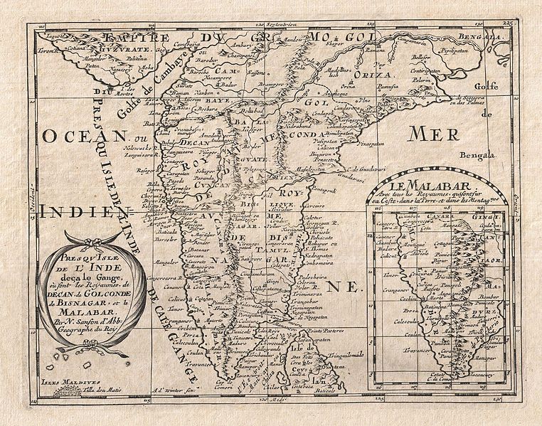
Presqu'Isle de L'Inde deca le Gange, ou sont les Royaumes de Decan, de Golconde, de Bisnagar, et le Malabar. |
|||||
| الوصف |
English: A small but attractive 1652 map of India by the French cartographer Nicholas Sanson. Covers the subcontinent From the Bay of Bengal and the Gulf of Cambay to Ceylon (Sri Lanka). Offers impressive detail given that the interior of India was largely unknown to the west until the British survey's of the late 18th century. The vast Mogul Empire sprawls across the northern part of the map. Further south the kingdoms of Deccan, Malabar, Bisnagar, and Golconda, among others, are noted. As an indicator of how just out of date European knowledge of this region was, most of these kingdoms had fallen to ruin over 100 years prior to the publication of this map. The Portuguese enclave of Goa on India's west coast is noted. In the lower right quadrant there is an inset of the Malabar Coast. The lower left hand quadrant features a curious and speculative depiction of the Maldives. |
|||||
| التاريخ | ١٦٥٢ (undated) | |||||
| الأبعاد | ارتفاع: ٨٫٠ إنش (٢٠٫٣ سم)؛ عرض: ١٠٫٠ إنش (٢٥٫٤ سم) | |||||
| رقم التصنيف |
وصلة موقع جيوغرافيكوس: India-sanson-1652 |
|||||
| المصدر/المصور |
Sanson D'Abbeville, Nicolas, L'Asie en Plusieurs Cartes & En Divers Traitez De Geographie, Et D'Histoire…, Paris: Chez l'auteur, 1652.
|
|||||
| الترخيص (إعادة استخدام هذا الملف) |
|
|||||
تاريخ الملف
اضغط على زمن/تاريخ لرؤية الملف كما بدا في هذا الزمن.
| زمن/تاريخ | صورة مصغرة | الأبعاد | مستخدم | تعليق | |
|---|---|---|---|---|---|
| حالي | 01:38، 24 مارس 2011 | | 2٬500 × 1٬966 (1٫45 ميجابايت) | BotMultichillT | {{subst:User:Multichill/Geographicus |link=http://www.geographicus.com/P/AntiqueMap/India-sanson-1652 |product_name=1652 Sanson Map of India |map_title=Presqu'Isle de L'Inde deca le Gange, ou sont les Royaumes de Decan, de Golconde, de Bisnagar, et le Mal |
استخدام الملف
الصفحتان التاليتان تستخدمان هذا الملف:
الاستخدام العالمي للملف
الويكيات الأخرى التالية تستخدم هذا الملف:
- الاستخدام في af.wikipedia.org
- الاستخدام في bn.wikipedia.org
- الاستخدام في en.wikipedia.org
- الاستخدام في sl.wikipedia.org
- الاستخدام في ta.wikipedia.org