
ملف:1852 Middlesex Canal (Massachusetts) map.jpg

حجم هذه المعاينة: 411 × 599 بكسل. الأبعاد الأخرى: 165 × 240 بكسل | 329 × 480 بكسل | 527 × 768 بكسل | 703 × 1٬024 بكسل | 2٬310 × 3٬365 بكسل.
الملف الأصلي (2٬310 × 3٬365 بكسل حجم الملف: 9٫03 ميجابايت، نوع MIME: image/jpeg)
| هذا ملف من ويكيميديا كومنز. معلومات من صفحة وصفه مبينة في الأسفل. كومنز مستودع ملفات ميديا ذو رخصة حرة. |
_map.jpg)
ملخص
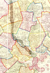
| الوصف | Map of the lower stretch of the Middlesex Canal, north of Boston, Massachusetts, 1852. This map was made about the time the canal was abandoned, some 50 years after its construction was completed. |
| التاريخ | |
| المصدر | Map entitled "Boston and vicinity", by F. G. Sidney and R. P. Smith, published by J. B. Shields of Boston, 1852. This scan is from the David Rumsey Map Collection, and has been cropped to remove extraneous terrain and digitally enhanced to emphasize the canal's route. |
| المؤلف | F. G. Sidney and R. P. Smith. |
| الترخيص (إعادة استخدام هذا الملف) |
The following text is taken from the David Rumsey web site: Images copyright © 2000 by Cartography Associates. Images may be reproduced or transmitted, but not for commercial use. For commercial use or commercial republication, contact carto@luna-img.com. This work is licensed under a Creative Commons License. |
ترخيص
هذا الملف مُرخَّص برخصة المشاع الإبداعي العامة المُلزِمة بنسب العمل إلى مُؤَلِّفه 2.0
- يحقُّ لك:
- مشاركة العمل – نسخ العمل وتوزيعه وبثُّه
- إعادة إنتاج العمل – تعديل العمل
- حسب الشروط التالية:
- نسب العمل إلى مُؤَلِّفه – يلزم نسب العمل إلى مُؤَلِّفه بشكل مناسب وتوفير رابط للرخصة وتحديد ما إذا أجريت تغييرات. بالإمكان القيام بذلك بأية طريقة معقولة، ولكن ليس بأية طريقة تشير إلى أن المرخِّص يوافقك على الاستعمال.
تاريخ الملف
اضغط على زمن/تاريخ لرؤية الملف كما بدا في هذا الزمن.
| زمن/تاريخ | صورة مصغرة | الأبعاد | مستخدم | تعليق | |
|---|---|---|---|---|---|
| حالي | 16:49، 14 يناير 2007 | | 2٬310 × 3٬365 (9٫03 ميجابايت) | Daderot | {{Information |Description=Map of the lower stretch of the Middlesex Canal, north of Boston, Massachusetts, 1852. This map was made about the time the canal was abandoned, some 50 years after its construction was completed. |Source=Map entitled "Boston an |
استخدام الملف
لا توجد صفحات تستخدم هذا الملف.
الاستخدام العالمي للملف
الويكيات الأخرى التالية تستخدم هذا الملف:
- الاستخدام في arz.wikipedia.org
- الاستخدام في ceb.wikipedia.org
- الاستخدام في de.wikipedia.org
- الاستخدام في en.wikipedia.org
- Cambridge, Massachusetts
- Everett, Massachusetts
- Malden, Massachusetts
- Medford, Massachusetts
- Melrose, Massachusetts
- Woburn, Massachusetts
- Arlington, Massachusetts
- Reading, Massachusetts
- Stoneham, Massachusetts
- Wakefield, Massachusetts
- Winchester, Massachusetts
- Brighton, Boston
- Middlesex Canal
- History of Boston
- الاستخدام في fr.wikipedia.org
- الاستخدام في he.wikipedia.org
- الاستخدام في it.wikipedia.org
- الاستخدام في ja.wikipedia.org
- الاستخدام في pt.wikipedia.org
- الاستخدام في ro.wikipedia.org
- الاستخدام في ru.wikipedia.org
- الاستخدام في uk.wikipedia.org
- الاستخدام في www.wikidata.org
- الاستخدام في zh.wikipedia.org
_map.jpg)