
ملف:Antarctica Without Ice Sheet.png

الملف الأصلي (782 × 1٬000 بكسل حجم الملف: 675 كيلوبايت، نوع MIME: image/png)
| هذا ملف من ويكيميديا كومنز. معلومات من صفحة وصفه مبينة في الأسفل. كومنز مستودع ملفات ميديا ذو رخصة حرة. |
ملخص
| الوصف |
Русский: Рельеф Антарктиды с учетом поднятия земной коры после таяния ледников и повышения уровня океана
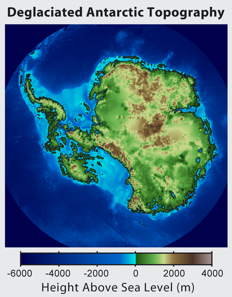
English: This is topographic map of Antarctica after removing the ice sheet and accounting for both isostatic rebound and sea level rise. Hence this map suggests what Antarctica may have looked like 35 million years ago, when the Earth was warm enough to prevent the formation of large-scale ice sheets in Antarctica.
Isostatic rebound is the result of the weight of the ice sheet depressing the land under it. After the ice is removed, the land will rise over a period of thousands of years by an amount approximately 1/3 as high as the ice sheet that was removed (because rock is 3 times as dense as ice). Approximately half the uplift occurs during the first two thousand years. If the ice sheet is removed over more than a few thousand years, then it is possible that a majority of the uplift will occur before the ice sheet fully disappears. As indicated in the map, Antarctica consists of a large continental region (East Antarctica) and group of seas and smaller land regions (West Antarctica). Since the West Antarctic ice sheet is partially anchored below sea level, this region is less stable and more likely to be affected by global warming. Even so, it is likely that during the next century increased precipitation over Antarctica will offset melting. Even in the event of severe sustained warming, it would take many thousands of years for Eastern Antarctica to be fully deglaciated.Français : Carte topographique de l'Antarctique après avoir retirer la couche de glace et pris en compte le rebond isostatique ainsi que la montée du niveau de la mer Par conséquent cette carte montre ce à quoi l'Antarctique aurait pu ressembler il y a 35 millions d'années, quand la Terre était suffisament chause pour prévenir la formation d'une importante calotte glaciaire en Antarctique.
Le rebond isostatique est la conséquence de la couche de glace qui fait pression sur le sol et crée des dépressions. Après le retrait de la glace, le sol s'élève sur une période de milliers d'années par un rythme correspondant à un tiers de la hauteur de la couche de glace qui fut retirée (car la roche est trois fois plus dense que la glace). La moitié de l'élévation se fait pendant les deux premiers milliers d'années. Si la glace se retire sur une période dépassant plusieurs milliers d'année, il est possible que le rebond ait lieu avant que la couche de glace ne disparaisse complètement. Comme montré sur la carte, l'Antarctique est composé d'une large région continentale (Antarctique oriental) et d'un groupe de mers et de petites régions terrestres (Antarctique occidental). Puisque la plaque glaciaire de l'Arctique occidental est en partie en dessous du niveau de la mer, cette région est moins stable et plus susceptible d'être affectée par le réchauffement climatique. En dépit de cela, des précipitation en Antarctique peuvent compenser la fonte. La fonte de l'Antarctique oriental prendra plusieurs milliers d'années, même en cas de réchauffement sévère et continu. |
| التاريخ | |
| المصدر | http://www.globalwarmingart.com/wiki/File:Antarctica_Without_Ice_Sheet_png |
| المؤلف | Image created by Robert A. Rohde / Global Warming Art |
| إصدارات أخرى | File:Deglaciated Antarctic Topography.png – with no description (internationalized) |
ترخيص

|
يسمح نسخ وتوزيع و/أو تعديل هذه الوثيقة تحت شروط رخصة جنو للوثائق الحرة، الإصدار 1.2 أو أي إصدار لاحق تنشره مؤسسة البرمجيات الحرة؛ دون أقسام ثابتة ودون نصوص أغلفة أمامية ودون نصوص أغلفة خلفية. نسخة من الرخصة تم تضمينها في القسم المسمى GNU Free Documentation License. |
- يحقُّ لك:
- مشاركة العمل – نسخ العمل وتوزيعه وبثُّه
- إعادة إنتاج العمل – تعديل العمل
- حسب الشروط التالية:
- نسب العمل إلى مُؤَلِّفه – يلزم نسب العمل إلى مُؤَلِّفه بشكل مناسب وتوفير رابط للرخصة وتحديد ما إذا أجريت تغييرات. بالإمكان القيام بذلك بأية طريقة معقولة، ولكن ليس بأية طريقة تشير إلى أن المرخِّص يوافقك على الاستعمال.
- الإلزام بترخيص المُشتقات بالمثل – إذا أعدت إنتاج المواد أو غيرت فيها، فيلزم أن تنشر مساهماتك المُشتقَّة عن الأصل تحت ترخيص الأصل نفسه أو تحت ترخيص مُتوافِقٍ معه.
تاريخ الملف
اضغط على زمن/تاريخ لرؤية الملف كما بدا في هذا الزمن.
| زمن/تاريخ | صورة مصغرة | الأبعاد | مستخدم | تعليق | |
|---|---|---|---|---|---|
| حالي | 16:56، 16 يونيو 2015 | | 782 × 1٬000 (675 كيلوبايت) | Szczureq | larger image |
| 05:57، 10 أكتوبر 2012 |  | 469 × 600 (316 كيلوبايت) | Strannik27 | User created page with UploadWizard |
استخدام الملف
الصفحة التالية تستخدم هذا الملف:
الاستخدام العالمي للملف
الويكيات الأخرى التالية تستخدم هذا الملف:
- الاستخدام في ast.wikipedia.org
- الاستخدام في ban.wikipedia.org
- الاستخدام في ba.wikipedia.org
- الاستخدام في be-tarask.wikipedia.org
- الاستخدام في be.wikipedia.org
- الاستخدام في br.wikipedia.org
- الاستخدام في bxr.wikipedia.org
- الاستخدام في ca.wikipedia.org
- الاستخدام في cs.wikipedia.org
- الاستخدام في de.wikipedia.org
- الاستخدام في en.wikipedia.org
- الاستخدام في es.wikipedia.org
- الاستخدام في es.wikibooks.org
- الاستخدام في fr.wikipedia.org
- الاستخدام في id.wikipedia.org
- الاستخدام في it.wikipedia.org
- الاستخدام في ja.wikipedia.org
- الاستخدام في ka.wikipedia.org
- الاستخدام في kn.wikipedia.org
- الاستخدام في la.wikipedia.org
- الاستخدام في mn.wikipedia.org
- الاستخدام في nl.wikipedia.org
- الاستخدام في no.wikipedia.org
- الاستخدام في pl.wikipedia.org
- الاستخدام في ru.wikipedia.org
- الاستخدام في tg.wikipedia.org
- الاستخدام في tr.wikipedia.org
- الاستخدام في uk.wikipedia.org
- الاستخدام في zh.wikipedia.org
- الاستخدام في zu.wikipedia.org