
ملف:Approximate extension of Alodia based on accounts of Ibn Hawqal.png

حجم هذه المعاينة: 800 × 581 بكسل. الأبعاد الأخرى: 320 × 232 بكسل | 640 × 464 بكسل | 813 × 590 بكسل.
الملف الأصلي (813 × 590 بكسل حجم الملف: 106 كيلوبايت، نوع MIME: image/png)
| هذا ملف من ويكيميديا كومنز. معلومات من صفحة وصفه مبينة في الأسفل. كومنز مستودع ملفات ميديا ذو رخصة حرة. |
ملخص
| الوصف |
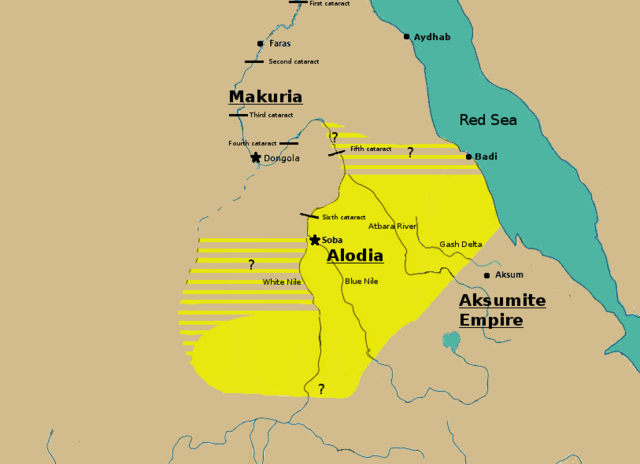
English: Initially based on map IX from the book "The Kingdom of Alwa" (see the first four versions of the map to see the faithful copy).[1] The original map had several problems, so I decided to modify it. 1) Zarroug had Alodia extend as far west as Darfur. However, there is still virtually no archaeological evidence supporting this assumption.[2] 2) The exact nothern border is still desputed; it is generally placed between Abu Hamad and the confluence of the Nile and the Atbara.[3] 3) Zarroug shows all regions west of the Nile as part of Alodia. However, the traveller Ibn Hawqal explicitly stated that parts of the region west of the White Nile were part of Makuria. The Nuba mountains were probably part of Alodia, hence I included stripes and a question mark for the area between the confluence of the two Niles and the Nuba mountains.[4] 4) There is little evidence that the Bayuda desert (between ed Debba and Omdurman) was part of either Makuria or Alodia.[5]
|
| التاريخ | |
| المصدر | عمل شخصي |
| المؤلف | LeGabrie |
ترخيص
أنا، صاحب حقوق التأليف والنشر لهذا العمل، أنشر هذا العمل تحت الرخصة التالية:
هذا الملفُّ مُرخَّصٌ برخصة المشاع الإبداعي الدَّوليَّة المُلزِمة بنسب العمل إلى مُؤَلِّفه وبترخيص المُشتقَّات بالمثل 4.0.
- يحقُّ لك:
- مشاركة العمل – نسخ العمل وتوزيعه وبثُّه
- إعادة إنتاج العمل – تعديل العمل
- حسب الشروط التالية:
- نسب العمل إلى مُؤَلِّفه – يلزم نسب العمل إلى مُؤَلِّفه بشكل مناسب وتوفير رابط للرخصة وتحديد ما إذا أجريت تغييرات. بالإمكان القيام بذلك بأية طريقة معقولة، ولكن ليس بأية طريقة تشير إلى أن المرخِّص يوافقك على الاستعمال.
- الإلزام بترخيص المُشتقات بالمثل – إذا أعدت إنتاج المواد أو غيرت فيها، فيلزم أن تنشر مساهماتك المُشتقَّة عن الأصل تحت ترخيص الأصل نفسه أو تحت ترخيص مُتوافِقٍ معه.
تاريخ الملف
اضغط على زمن/تاريخ لرؤية الملف كما بدا في هذا الزمن.
| زمن/تاريخ | صورة مصغرة | الأبعاد | مستخدم | تعليق | |
|---|---|---|---|---|---|
| حالي | 15:20، 27 نوفمبر 2018 | | 813 × 590 (106 كيلوبايت) | LeGabrie | Deleted stripes in Bayuda desert |
| 15:47، 28 أكتوبر 2018 |  | 703 × 590 (114 كيلوبايت) | LeGabrie | decreased width | |
| 12:51، 15 أكتوبر 2018 |  | 813 × 590 (108 كيلوبايت) | LeGabrie | Added Gash Delta | |
| 11:38، 29 سبتمبر 2018 |  | 813 × 590 (108 كيلوبايت) | LeGabrie | Extended the beams over the entire Bayuda | |
| 12:12، 4 سبتمبر 2018 |  | 813 × 590 (111 كيلوبايت) | LeGabrie | added question mark | |
| 11:59، 4 سبتمبر 2018 |  | 813 × 590 (108 كيلوبايت) | LeGabrie | Cut the beams in Darfur | |
| 00:55، 1 سبتمبر 2018 |  | 813 × 590 (114 كيلوبايت) | LeGabrie | Increased script size | |
| 00:51، 1 سبتمبر 2018 |  | 813 × 590 (114 كيلوبايت) | LeGabrie | small fix | |
| 00:49، 1 سبتمبر 2018 |  | 813 × 590 (114 كيلوبايت) | LeGabrie | Made it prettier | |
| 21:14، 1 فبراير 2018 |  | 813 × 590 (155 كيلوبايت) | LeGabrie | Added white beams and question marks to highlight the uncertainties of Zarroug's map. These uncertainties are: The extension into Darfur,the question of ownership of northern Kordofan and the beginning of Al-Abwab. The concrete amount of desert aside o... |
استخدام الملف
ال5 صفحات التالية تستخدم هذا الملف:
الاستخدام العالمي للملف
الويكيات الأخرى التالية تستخدم هذا الملف:
- الاستخدام في arz.wikipedia.org
- الاستخدام في azb.wikipedia.org
- الاستخدام في cs.wikipedia.org
- الاستخدام في de.wikipedia.org
- الاستخدام في en.wikipedia.org
- الاستخدام في fa.wikipedia.org
- الاستخدام في fi.wikipedia.org
- الاستخدام في fr.wikipedia.org
- الاستخدام في id.wikipedia.org
- الاستخدام في ms.wikipedia.org
- الاستخدام في nl.wikipedia.org
- الاستخدام في pt.wikipedia.org
- الاستخدام في ru.wikipedia.org
- الاستخدام في sl.wikipedia.org
- الاستخدام في sr.wikipedia.org
- الاستخدام في sv.wikipedia.org
- الاستخدام في ta.wikipedia.org
- الاستخدام في th.wikipedia.org
- الاستخدام في tl.wikipedia.org
- الاستخدام في uk.wikipedia.org
- الاستخدام في vi.wikipedia.org
- الاستخدام في zh.wikipedia.org