
ملف:Big Thomson Mesa, Capitol Reef National Park, Utah.jpg
الملف الأصلي (4٬256 × 2٬832 بكسل حجم الملف: 1٫36 ميجابايت، نوع MIME: image/jpeg)
| هذا ملف من ويكيميديا كومنز. معلومات من صفحة وصفه مبينة في الأسفل. كومنز مستودع ملفات ميديا ذو رخصة حرة. |
ملخص
| الوصف |
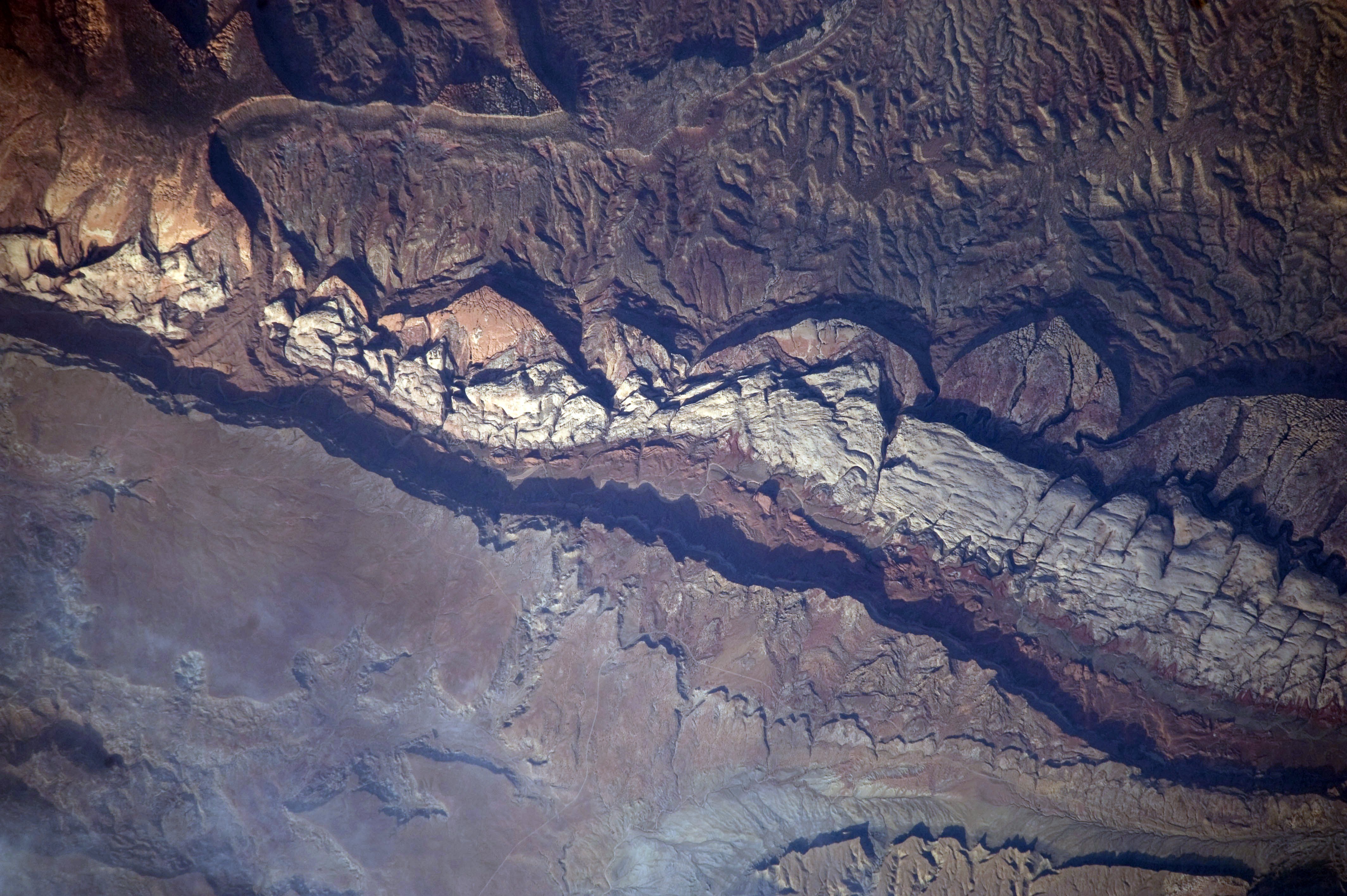
English: This detailed astronaut photograph shows part of Big Thomson Mesa, near the southern end of Capitol Reef National Park. Capitol Reef National Park is located on the Colorado Plateau, which occupies the adjacent quarters of Arizona, Colorado, New Mexico, and Utah. Big Thomson Mesa (image left) is part of a large feature known as the en:Waterpocket Fold. The Fold is a geologic structure called a monocline—layers of generally flat-lying sedimentary rock with a steep, one-sided bend, like a carpet runner draped over a stair step. Geologists think that monoclines on the Colorado Plateau result from faulting (cracking) of deeper and more brittle crystalline rocks under tectonic pressure; while the crystalline rocks were broken into raised or lowered blocks, the overlaying, less brittle sedimentary rocks were flexed without breaking.
The portion of the Waterpocket Fold illustrated in this image includes layered rocks formed during the Mesozoic Era (about 250 – 65 million years ago). The oldest layers are at the bottom of the sequence, with each successive layer younger than the preceding one going upwards in the sequence. Not all of the formation’s rock layers are clearly visible, but some of the major layers (units to geologists) can be easily distinguished. The top half of the image includes the oldest rocks in the view: dark brown and dark green Moenkopi and Chinle Formations. Moving toward the foot of the mesa, two strikingly coloured units are visible near image centre: light red to orange Wingate Sandstone and white Navajo Sandstone. Beyond those units, reddish brown to brown Carmel Formation and Entrada Sandstone occupy a topographic bench at the foot of a cliff. The top of the cliff face above this bench—Big Thomson Mesa—is comprised of brown Dakota Sandstone. This sequence represents more than 100 million years of sediments being deposited and turned into rock. Much younger Quaternary (2-million- to approximately 10,000-year-old) deposits are also present in the view. The area shown in this astronaut photograph is located approximately 65 kilometers to the southeast of Fruita, UT near the southern end of Capitol Reef National Park.
|
||||||||||||||||||||||||||||||||||||||||||||||||||
| التاريخ | |||||||||||||||||||||||||||||||||||||||||||||||||||
| المصدر | NASA Earth Observatory | ||||||||||||||||||||||||||||||||||||||||||||||||||
| المؤلف | This image was taken by the NASA Expedition 20 crew | ||||||||||||||||||||||||||||||||||||||||||||||||||
| موقع الكاميرا | | هذه وغيرها من الصور في مواقعها على: خريطة الشارع المفتوحة |
|---|
فُهرِست هذه الصُّورة أَو هذا التَّسجيل المرئي لدى مركز جونسون للفضاء التَّابعة لوكالة الفضاء الأَمريكيَّة (ناسا) تحت المُعرِّف ISS020-E-9861. لا يُشير هذه الوَسم إلى حالة حقوق التَّأليف والنَّشر الخاصَّة بالعمل المُرفَق؛ لا يزال وَسم حقوق التَّأليف والنَّشر مَطلُوباً، راجع كومنز:ترخيص لمزيدٍ من المعلومات. لغات أخرى:
|
Image acquired with a Nikon D3 digital camera fitted with an 800 mm lens, and is provided by the ISS Crew Earth Observations experiment and Image Science & Analysis Laboratory, Johnson Space Centre.
ترخيص
| يقع هذا العمل في النِّطاق العامّ في الولايات المُتحدة الأمريكيَّة لأَنَّه عملٌ خالِصٌ من إِنتاج وكالة الفضاء الأمريكيَّة. تنصُ حقوق التَّأليف والنَّشر الخاصَّة بوكالة الفضاء الأمريكيَّة على أنَّ "أعمال الوكالة غير مَحميَّة بحقوق التَّأليف والنَّشر ما لم يُذكر خلافُ ذلك". لمزيدٍ من المعلومات انظر القالِب {{PD-USGov}} وصفحة حقوق التَّأليف والنَّشر الخاصَّة بالوكالة وصفحة سياسة الصُّور الخاصَّة بمُختبر الدَّفع النَّفَّاث. | ||
 |
تنبيهات:
|
تاريخ الملف
اضغط على زمن/تاريخ لرؤية الملف كما بدا في هذا الزمن.
| زمن/تاريخ | صورة مصغرة | الأبعاد | مستخدم | تعليق | |
|---|---|---|---|---|---|
| حالي | 12:56، 31 يناير 2011 | | 4٬256 × 2٬832 (1٫36 ميجابايت) | Originalwana | higher res |
| 18:04، 6 يوليو 2009 |  | 1٬440 × 960 (1٫02 ميجابايت) | Originalwana | {{Information |Description={{en|1=This detailed astronaut photograph shows part of Big Thomson Mesa, near the southern end of Capitol Reef National Park. Capitol Reef National Park is located on the Colorado Plateau, which occupies the adjacent quarters o |
استخدام الملف
الصفحة التالية تستخدم هذا الملف:
الاستخدام العالمي للملف
الويكيات الأخرى التالية تستخدم هذا الملف:
- الاستخدام في en.wikipedia.org
- الاستخدام في en.wikiversity.org
- الاستخدام في es.wikipedia.org
- الاستخدام في fr.wikipedia.org
- الاستخدام في he.wikipedia.org
- الاستخدام في is.wikipedia.org
- الاستخدام في pt.wikipedia.org