ملف:Breakup of Yugoslavia.gif
محتويات الصفحة غير مدعومة بلغات أخرى.
من ويكيبيديا، الموسوعة الحرة

الملف الأصلي(1٬545 × 1٬242 بكسل حجم الملف: 187 كيلوبايت، نوع MIME: image/gif، ‏ملفوف، ‏14 إطارا، ‏44ث)

This image could be re-created using vector graphics as an SVG file. This has several advantages; see Commons:Media for cleanup for more information. If an SVG form of this image is available, please upload it and afterwards replace this template with {{vector version available|new image name}}. It is recommended to name the SVG file "Breakup of Yugoslavia.svg" - then the template Vector version available (or Vva) does not need the new image name parameter.

ملخص

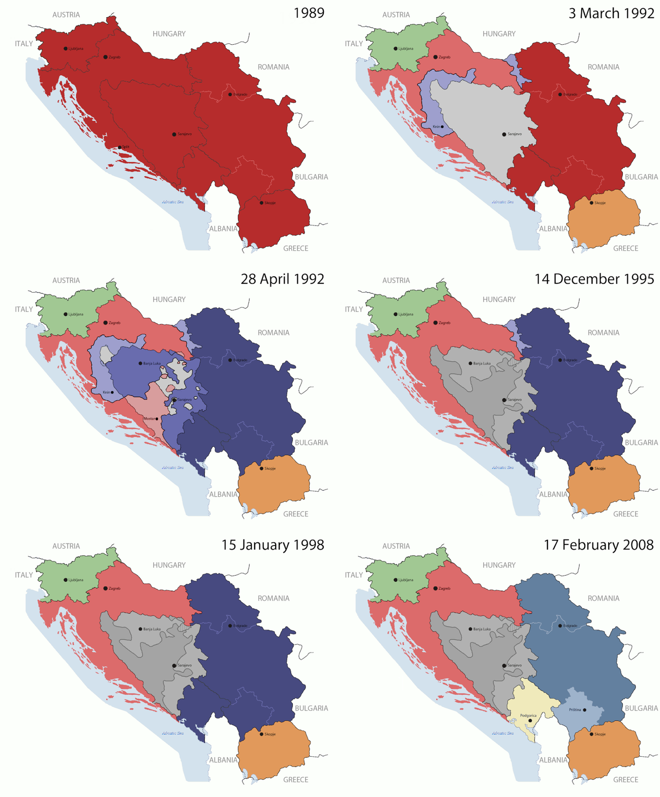
Key:

Yugoslavia (1943–1992) SFR Yugoslavia
Croatia (1991–present) Croatia
Herzeg-Bosnia (1992–1994)
UNTAES (1996–1998)
Federal Republic of Yugoslavia / Serbia and Montenegro (1992–2006) Serbia and Montenegro
Republika Srpska (1992–present) Republika Srpska
Serbian Krajina (1991–1995/96)
Republic of Bosnia and Herzegovina (1992–1995)
Bosnia and Herzegovina (1998–present) Bosnia and Herzegovina
Western Bosnia (1993–1995)
Serbia (2006–present) Serbia
Kosovo (under UNMIK control 1999–present; declaration of independence 2008) Kosovo
Montenegro (2006–present) Montenegro
Macedonia (1991–present) Macedonia
Slovenia (1991–present) Slovenia


الوصف

This is an animated GIF that shows the stages of the breakup of the SFR Yugoslavia in the 90's and 2000's. The map based off Morwen's map of the divisions of the SFRY, Which is licensed by the GFDL. The source for the dates of independence is the CIA World Factbook. These maps do not now show the Inter-Entity Boundary Line (IEBL) and/or the entities that are separated by it. The IEBL has been drawn based on this CIA map; the Brčko District has been drawn based on Image:BH municipality location.gif, by user:Ante Perkovic. I might add them in the future.

Since the original map was GFDL, this image is as well.

A map depicting Kosovo's final status is ready once it takes effect.


Changelog for versions 2/3:

Here are some changes in this new build of the map:

  • The Kosovo boundary has been given a shade of red instead of the previous UN blue since they are a province of Serbia under UNIMIK control.
  • Montenegro's color has been changed to a golden shade close to what's on the flag.
  • The IEBL and the Brčko District has been redrawn because I deleted the original map; the color for the Republika Srpska is lighter.
  • The dates are at the top left hand corner of the map instead of the bottom.
  • I have taken a new approach as to the boundaries. Each part of Yugoslavia now shows the boundary on the maps starting the year they broke away. I feel this change helps readers understand the breakup better.
  • The SFRY and the FRY are in different shades since the FRY was never accepted as the successor to the former by the UN.
  • The colors for the entities of BiH have been removed as to not confuse people into thinking that they are independent states. What remains is the IEBL with both entities in green.
  • The Kosovo boundary is finally in hash marks!
  • The Brčko District has been removed. The sale is too small to show accurately.

Changelog for version 4:

  • The map is larger!
  • The image has been rebuilt to include the eastern part of FYR Macedonia.
  • The image has been updated to take in Kosovo's new status.
  • The IEBL is now a darker line.
  • Montenegro, Kosovo, and FRY/SCG/Serbia have new colors!

Changelog for version 5:

  • Rebuilt
  • Larger map: size of base image
  • Accurate Inter-Entity Boundary Line
التاريخ 24 July 2006 (orginal upload date)
المصدر Made by Hoshie; see above for more details on sources.
المؤلف Hoshie
إصدارات أخرى

ترخيص

GNU head يسمح نسخ وتوزيع و/أو تعديل هذه الوثيقة تحت شروط رخصة جنو للوثائق الحرة، الإصدار 1.2 أو أي إصدار لاحق تنشره مؤسسة البرمجيات الحرة؛ دون أقسام ثابتة ودون نصوص أغلفة أمامية ودون نصوص أغلفة خلفية. نسخة من الرخصة تم تضمينها في القسم المسمى GNU Free Documentation License.
w:ar:مشاع إبداعي
نسب العمل إلى مُؤَلِّفه الإلزام بترخيص المُشتقات بالمثل
هذا الملفُّ مُرخَّص بموجب رخصة المشاع الإبداعي نسبة المُصنَّف إِلى مُؤَلِّفه - المشاركة بالمثل 3.0 العامة
يحقُّ لك:
  • مشاركة العمل – نسخ العمل وتوزيعه وبثُّه
  • إعادة إنتاج العمل – تعديل العمل
حسب الشروط التالية:
  • نسب العمل إلى مُؤَلِّفه – يلزم نسب العمل إلى مُؤَلِّفه بشكل مناسب وتوفير رابط للرخصة وتحديد ما إذا أجريت تغييرات. بالإمكان القيام بذلك بأية طريقة معقولة، ولكن ليس بأية طريقة تشير إلى أن المرخِّص يوافقك على الاستعمال.
  • الإلزام بترخيص المُشتقات بالمثل – إذا أعدت إنتاج المواد أو غيرت فيها، فيلزم أن تنشر مساهماتك المُشتقَّة عن الأصل تحت ترخيص الأصل نفسه أو تحت ترخيص مُتوافِقٍ معه.
تمت إضافة علامة الترخيص لهذا الملف كجزء من رخصة جنو للوثائق الحرة تحديث الترخيص.

الشروحات

أضف شرحاً من سطر واحد لما يُمثِّله هذا الملف

العناصر المصورة في هذا الملف

يُصوِّر

05ca2aefea8406b809968643552d5095c847a42f

طريقة الاستدلال: SHA-1 الإنجليزية

١٩١٬٦٢٥ بايت

٤٤ ثانية

١٬٢٤٢ بكسل

١٬٥٤٥ بكسل

تاريخ الملف

اضغط على زمن/تاريخ لرؤية الملف كما بدا في هذا الزمن.

(الأحدث | الأقدم) عرض (أحدث 10  | ) (10 | 20 | 50 | 100 | 250 | 500).
زمن/تاريخصورة مصغرةالأبعادمستخدمتعليق
حالي07:40، 17 يوليو 2016تصغير للنسخة بتاريخ 07:40، 17 يوليو 20161٬545 × 1٬242 (187 كيلوبايت)מפתח-רשימהReverted to version as of 17:22, 21 August 2015 (UTC)
17:22، 21 أغسطس 2015تصغير للنسخة بتاريخ 17:22، 21 أغسطس 20151٬463 × 1٬158 (1٫81 ميجابايت)BraganzaReverted to version as of 03:57, 19 January 2010
17:22، 21 أغسطس 2015تصغير للنسخة بتاريخ 17:22، 21 أغسطس 20151٬545 × 1٬242 (187 كيلوبايت)BraganzaReverted to version as of 01:02, 19 December 2011
17:15، 21 أغسطس 2015تصغير للنسخة بتاريخ 17:15، 21 أغسطس 2015120 × 95 (3 كيلوبايت)Braganza03:57, 19. Jan. 2010
01:02، 19 ديسمبر 2011تصغير للنسخة بتاريخ 01:02، 19 ديسمبر 20111٬545 × 1٬242 (187 كيلوبايت)DIREKTORAdded details
18:09، 27 يوليو 2011تصغير للنسخة بتاريخ 18:09، 27 يوليو 20111٬545 × 1٬242 (170 كيلوبايت)DIREKTORSmall fixes
17:28، 27 يوليو 2011تصغير للنسخة بتاريخ 17:28، 27 يوليو 20111٬545 × 1٬242 (171 كيلوبايت)DIREKTORAdded UNMIK
16:38، 27 يوليو 2011تصغير للنسخة بتاريخ 16:38، 27 يوليو 20111٬545 × 1٬242 (165 كيلوبايت)DIREKTORDates for the last two frames.
12:10، 27 يوليو 2011تصغير للنسخة بتاريخ 12:10، 27 يوليو 20111٬545 × 1٬242 (149 كيلوبايت)DIREKTORLighter shade for country names
16:59، 26 يوليو 2011تصغير للنسخة بتاريخ 16:59، 26 يوليو 20111٬545 × 1٬242 (170 كيلوبايت)DIREKTORHigher res plus details
(الأحدث | الأقدم) عرض (أحدث 10  | ) (10 | 20 | 50 | 100 | 250 | 500).

الصفحة التالية تستخدم هذا الملف:

الاستخدام العالمي للملف

الويكيات الأخرى التالية تستخدم هذا الملف:

اعرض المزيد من الاستخدام العام لهذا الملف.

بيانات وصفية