
ملف:Canyons off LA.jpg
لا توجد دقة أعلى متوفرة.
Canyons_off_LA.jpg (720 × 511 بكسل حجم الملف: 35 كيلوبايت، نوع MIME: image/jpeg)
| هذا ملف من ويكيميديا كومنز. معلومات من صفحة وصفه مبينة في الأسفل. كومنز مستودع ملفات ميديا ذو رخصة حرة. |
ملخص
| الوصف |
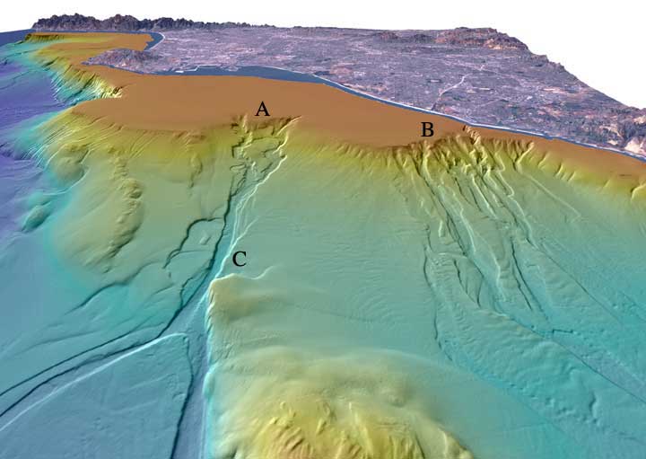
English: "Perspective view looking north over the San Gabriel (A) and Newport (B) submarine canyons. The distance across the bottom of the image is about 17 km with a vertical exaggeration of 6x. Both canyons formed when the San Gabriel River and the Santa Ana River flowed out across the Los Angeles Basin and offshore shelf when it was exposed during lower eustatic sea level. Newport Canyon begins less than 360 m from shore at the north end of Newport Harbor and is composed of individual channels that braid down the slope over a width of about 9 km. San Gabriel Canyon begins as a series of channels that join together midway down the slope and then split into two channels at the base of the slope. The width of San Gabriel Canyon at "C" is 815 m and incises about 25 m into the slope. Lasuen Knoll can be seen in the forground." |
| التاريخ | |
| المصدر | [1] |
| المؤلف | United States Geological Survey |
ترخيص
تقع هذه الصُّورة في النِّطاق العامّ لأنَّها تحتوي مواد حصريَّة مِن إِنتاج هيئة المساحة الجيولوجيَّة الأمريكيَّة في وزارة الداخلية في الولايات المُتحدة الأمريكيَّة. للمزيد مِن المعلومات انظر سياسية حقوق التَّأليف والنَّشر في موقع هيئة المساحة الجيولوجيَّة الأمريكيَّة الرسميَّة.
|
تاريخ الملف
اضغط على زمن/تاريخ لرؤية الملف كما بدا في هذا الزمن.
| زمن/تاريخ | صورة مصغرة | الأبعاد | مستخدم | تعليق | |
|---|---|---|---|---|---|
| حالي | 22:11، 26 يناير 2012 | | 720 × 511 (35 كيلوبايت) | Mikenorton |
استخدام الملف
الصفحة التالية تستخدم هذا الملف:
الاستخدام العالمي للملف
الويكيات الأخرى التالية تستخدم هذا الملف:
- الاستخدام في ca.wikipedia.org
- الاستخدام في cs.wikipedia.org
- الاستخدام في en.wikipedia.org
- الاستخدام في en.wikiversity.org
- الاستخدام في es.wikipedia.org
- الاستخدام في gl.wikipedia.org
- الاستخدام في it.wikipedia.org
- الاستخدام في it.wikibooks.org
- الاستخدام في it.wikiversity.org
- الاستخدام في ja.wikipedia.org
- الاستخدام في ka.wikipedia.org
- الاستخدام في mk.wikipedia.org
- الاستخدام في ru.wikipedia.org
- الاستخدام في tr.wikipedia.org
- الاستخدام في uk.wikipedia.org