
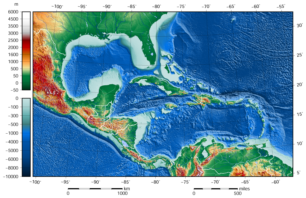
ملف:Caribbean Sea Gulf of Mexico shaded relief bathymetry land map.png
الملف الأصلي (1٬024 × 664 بكسل حجم الملف: 1٫1 ميجابايت، نوع MIME: image/png)
| هذا ملف من ويكيميديا كومنز. معلومات من صفحة وصفه مبينة في الأسفل. كومنز مستودع ملفات ميديا ذو رخصة حرة. |
ملخص
| الوصف |
English: The shaded relief bathymetry and land map of the Caribbean Sea and Gulf of Mexico area. The map was created using the Generic Mapping Tools, GMT, version 5.1.1. |
| التاريخ | |
| المصدر |
Own work using: the following Public Domain datasets for the relief:
.هذا الرسم المتجهي أُنشئ بواسطة GMT |
| المؤلف | Darekk2 using the ETOPO1 and GLOBE tiles |
| إصدارات أخرى |
The same image but contoured at -100 m: |

ترخيص
Attribution (in addition to the author of this map):
The NGDC in it's copyright notice says:
As required by 17 U.S.C. 403, third parties producing copyrighted works consisting predominantly of the material produced by U.S. government agencies must provide notice with such work(s) identifying the U.S. Government material incorporated and stating that such material is not subject to copyright protection within the United States. (...)
(for credits see the Source section).
and GLOBE and ETOPO1
(see above and the Source section)
- يحقُّ لك:
- مشاركة العمل – نسخ العمل وتوزيعه وبثُّه
- إعادة إنتاج العمل – تعديل العمل
- حسب الشروط التالية:
- نسب العمل إلى مُؤَلِّفه – يلزم نسب العمل إلى مُؤَلِّفه بشكل مناسب وتوفير رابط للرخصة وتحديد ما إذا أجريت تغييرات. بالإمكان القيام بذلك بأية طريقة معقولة، ولكن ليس بأية طريقة تشير إلى أن المرخِّص يوافقك على الاستعمال.
- الإلزام بترخيص المُشتقات بالمثل – إذا أعدت إنتاج المواد أو غيرت فيها، فيلزم أن تنشر مساهماتك المُشتقَّة عن الأصل تحت ترخيص الأصل نفسه أو تحت ترخيص مُتوافِقٍ معه.
تاريخ الملف
اضغط على زمن/تاريخ لرؤية الملف كما بدا في هذا الزمن.
| زمن/تاريخ | صورة مصغرة | الأبعاد | مستخدم | تعليق | |
|---|---|---|---|---|---|
| حالي | 09:58، 8 يونيو 2015 | | 1٬024 × 664 (1٫1 ميجابايت) | Darekk2 | added lakes ... and changed palette for land (white highest mountains) |
| 15:23، 12 مايو 2015 |  | 1٬024 × 664 (1٫09 ميجابايت) | Darekk2 | changed the illumination azimuth from 100 to 45 deg. | |
| 15:59، 21 مارس 2015 |  | 1٬024 × 664 (1٫11 ميجابايت) | Darekk2 | a little wider in the east | |
| 15:07، 21 مارس 2015 |  | 1٬024 × 664 (1٫11 ميجابايت) | Darekk2 | changed parallels of the projection, removed black borderline | |
| 15:05، 19 مارس 2015 |  | 1٬024 × 684 (1٫15 ميجابايت) | Darekk2 | shortened elevation and depth legends | |
| 18:25، 18 مارس 2015 |  | 1٬024 × 684 (1٫15 ميجابايت) | Darekk2 | User created page with UploadWizard |
استخدام الملف
الصفحتان التاليتان تستخدمان هذا الملف:
الاستخدام العالمي للملف
الويكيات الأخرى التالية تستخدم هذا الملف:
- الاستخدام في avk.wikipedia.org
- الاستخدام في en.wikipedia.org
- الاستخدام في gl.wikipedia.org
- الاستخدام في hr.wikipedia.org
- الاستخدام في sd.wikipedia.org
- الاستخدام في sr.wikipedia.org
- الاستخدام في vep.wikipedia.org