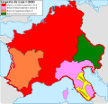
ملف:Carolingian empire 828.svg

محتويات الصفحة غير مدعومة بلغات أخرى.
من ويكيبيديا، الموسوعة الحرة

الملف الأصلي(ملف SVG، أبعاده 1٬091 × 1٬053 بكسل، حجم الملف: 348 كيلوبايت)

ملخص

الوصف
Español: Imperio carolingio en 828 antes de las guerras civiles.
التاريخ
المصدر

عمل شخصي

  • [1] Sur l'epoque de la désunion de la Septimanie de Royaume de Aquitaine, & de son érection en Duché, & sur l'acte de partage que fit l'an 817, l'empereur Luis-le-Débonaire de ses Etats entre ses fils.
  • [2] Pepin continued to hold Aquitaine; but the realm sustained various alterations in boundary: only a portion of Septimania, which had hitherto been conjoined with Aquitaine, was retained by him, namely the county of Carcassonne. On the north, the frontier was also somewhat contracted, but the loss was compensated by a dismemberment of Cisjurane Burgundy, three counties -Autun, towering in Roman magnificence: smiling Nevers, and dreary Avalon, where every stone appears stamped with vestiges of once animated nature.
  • [3]: At the Aachen assembly in February 828, Louis the Pious blamed the loss of Lower Pannonia on Balderic of Friuli's "cowardice". Louis the Pious therefore revoked Balderic's honors and divided the match of Friuli into four separate counties: Carantania, Carniola, Istria, and a now greatly reduced Friuli. [...] The province of Carantania at this time passed into the control of the Bavarian king and his eastern prefect. [...] Louis could justify the annexation of Carantania on the basis of the Ordenatio imperii which explicitly included Carantania as part of his Bavarian kingdom. But as the ruler of Italy, Lothar had cotrolled Friuli (including Carantania) since 817. Balderic's downfall in 828 and the resulting Bavarian annexation of Carantania therefore represented Louis's first agressive move against his eldest brother.
  • [4]: Pippin, another son of Lewis, had dominion in Aquitaine and Gascony.
  • [5]: En 817, en Aquisgram, se hizo división entre los hijos de Luis el Piadoso: y Lotario fue asociado al Imperio; Pepino obtuvo la Gascuña y la Aquitania con los territorios de Nevers, Autun, Avallen en la Borgoña.
  • [6]: Pepin continued to hold Aquitaine; but the realm sustained various alterations in boundary : only a portion of Septimania, which had hitherto been conjoined with Aquitaine, was retained by him, namely the county of Carcassonne. On the north, the frontier was also somewhat contracted, but the loss was compensated by a dismemberment of Cisjurane Burgundy, three counties— Autun, towering in Roman magnificence : smiling Nevers, and dreary Avalon, where every stone appears stamped with vestiges of once animated nature.
المؤلف Trasamundo
إصدارات أخرى

ترخيص

أنا، صاحب حقوق التأليف والنشر لهذا العمل، أنشر هذا العمل تحت الرخص التالية:
GNU head يسمح نسخ وتوزيع و/أو تعديل هذه الوثيقة تحت شروط رخصة جنو للوثائق الحرة، الإصدار 1.2 أو أي إصدار لاحق تنشره مؤسسة البرمجيات الحرة؛ دون أقسام ثابتة ودون نصوص أغلفة أمامية ودون نصوص أغلفة خلفية. نسخة من الرخصة تم تضمينها في القسم المسمى GNU Free Documentation License.
w:ar:مشاع إبداعي
نسب العمل إلى مُؤَلِّفه الإلزام بترخيص المُشتقات بالمثل
هذا الملف مرخص تحت المشاع المبدع مؤلفه 3.0 بلا رجعة, 2.5 عام, 2.0 عام و 1.0 عام الترخيص.
يحقُّ لك:
  • مشاركة العمل – نسخ العمل وتوزيعه وبثُّه
  • إعادة إنتاج العمل – تعديل العمل
حسب الشروط التالية:
  • نسب العمل إلى مُؤَلِّفه – يلزم نسب العمل إلى مُؤَلِّفه بشكل مناسب وتوفير رابط للرخصة وتحديد ما إذا أجريت تغييرات. بالإمكان القيام بذلك بأية طريقة معقولة، ولكن ليس بأية طريقة تشير إلى أن المرخِّص يوافقك على الاستعمال.
  • الإلزام بترخيص المُشتقات بالمثل – إذا أعدت إنتاج المواد أو غيرت فيها، فيلزم أن تنشر مساهماتك المُشتقَّة عن الأصل تحت ترخيص الأصل نفسه أو تحت ترخيص مُتوافِقٍ معه.
لك أن تختار الرخصة التي تناسبك.

الشروحات

أضف شرحاً من سطر واحد لما يُمثِّله هذا الملف

العناصر المصورة في هذا الملف

يُصوِّر

١٣ مارس 2010

6908994735cabc5747629f33d2b509c07bfe85f3

طريقة الاستدلال: SHA-1 الإنجليزية

٣٥٦٬٧٠٣ بايت

١٬٠٥٣ بكسل

١٬٠٩١ بكسل

تاريخ الملف

اضغط على زمن/تاريخ لرؤية الملف كما بدا في هذا الزمن.

زمن/تاريخصورة مصغرةالأبعادمستخدمتعليق
حالي12:09، 28 أكتوبر 2021تصغير للنسخة بتاريخ 12:09، 28 أكتوبر 20211٬091 × 1٬053 (348 كيلوبايت)RowanwindwhistlerLighter colours, fake text added for better rendering in articles (real text is now hidden).
08:34، 4 مايو 2016تصغير للنسخة بتاريخ 08:34، 4 مايو 20161٬091 × 1٬053 (251 كيلوبايت)RowanwindwhistlerSofter colours form http://colorbrewer2.org/
21:38، 22 أبريل 2016تصغير للنسخة بتاريخ 21:38، 22 أبريل 20161٬091 × 1٬053 (251 كيلوبايت)RowanwindwhistlerClear shapes, some colours from https://en.wikipedia.org/wiki/Wikipedia:WikiProject_Maps/Conventions
18:30، 13 مارس 2010تصغير للنسخة بتاريخ 18:30، 13 مارس 20101٬091 × 1٬053 (940 كيلوبايت)Trasamundolegend
18:26، 13 مارس 2010تصغير للنسخة بتاريخ 18:26، 13 مارس 20101٬091 × 1٬053 (940 كيلوبايت)Trasamundo{{Information |Description={{es|1=Imperio carolingio en 828 antes de las guerras civiles.}} |Source={{own}} |Author=Trasamundo |Date=13 March 2010 |Permission= |other_versions= }} Category:Maps of the Carolingian Empire

الصفحة التالية تستخدم هذا الملف:

الاستخدام العالمي للملف

الويكيات الأخرى التالية تستخدم هذا الملف:

بيانات وصفية