
ملف:Cyclone Idai floods near Beira 2019-3-19 by ESA Copernicus Sentinel-1.jpg

الملف الأصلي (3٬761 × 2٬116 بكسل حجم الملف: 2٫56 ميجابايت، نوع MIME: image/jpeg)
| هذا ملف من ويكيميديا كومنز. معلومات من صفحة وصفه مبينة في الأسفل. كومنز مستودع ملفات ميديا ذو رخصة حرة. |
ملخص
| الوصف |
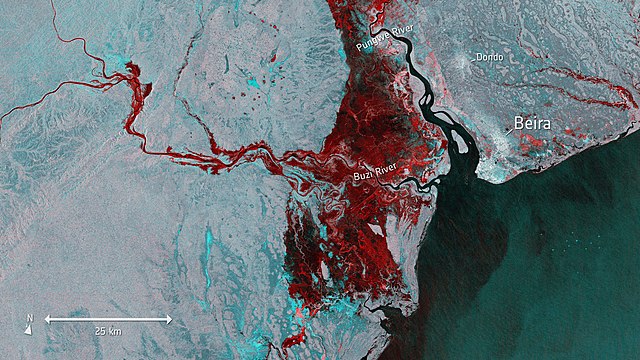
English: Cyclone Idai generated floods near port town of Beira, Mozambique imaged on 19 March 2019 by European Space Agency satellite Copernicus Sentinel-1. This image shows the extent of flooding, depicted in red, around the port town of Beira. For example large parts of Buzi district, located west and southwest of Beira, is flooded. |
| التاريخ | |
| المصدر | http://www.esa.int/spaceinimages/Images/2019/03/Floods_imaged_by_Copernicus_Sentinel-1 |
| المؤلف | Copernicus Sentinel-1 -satellite (modified Copernicus Sentinel data (2019), processed by ESA, CC BY-SA 3.0 IGO) |
| إصدارات أخرى |
|

ترخيص
This media was created by the European Space Agency (ESA).
Where expressly so stated, images or videos are covered by the Creative Commons Attribution-ShareAlike 3.0 IGO (CC BY-SA 3.0 IGO) licence, ESA being an Intergovernmental Organisation (IGO), as defined by the CC BY-SA 3.0 IGO licence. The user is allowed under the terms and conditions of the CC BY-SA 3.0 IGO license to Reproduce, Distribute and Publicly Perform the ESA images and videos released under CC BY-SA 3.0 IGO licence and the Adaptations thereof, without further explicit permission being necessary, for as long as the user complies with the conditions and restrictions set forth in the CC BY-SA 3.0 IGO licence, these including that:
See the ESA Creative Commons copyright notice for complete information, and this article for additional details.
|
 | |
هذا الملف مرخص تحت ترخيص المشاع الإبداعي النسبة-الترخيص بالمثل 3.0 IGO. نسب العمل لمُؤَلِّفه: ESA, CC BY-SA IGO 3.0
| ||

|
This image contains data from a satellite in the Copernicus Programme, such as Sentinel-1, Sentinel-2 or Sentinel-3. Attribution is required when using this image.
نسب العمل لمُؤَلِّفه: Contains modified Copernicus Sentinel data 2019
The use of Copernicus Sentinel Data is regulated under EU law (Commission Delegated Regulation (EU) No 1159/2013 and Regulation (EU) No 377/2014). Relevant excerpts:
Free access shall be given to GMES dedicated data [...] made available through GMES dissemination platforms [...].
Access to GMES dedicated data [...] shall be given for the purpose of the following use in so far as it is lawful:
GMES dedicated data [...] may be used worldwide without limitations in time.
GMES dedicated data and GMES service information are provided to users without any express or implied warranty, including as regards quality and suitability for any purpose. |
| الشروح | هذه الصورة مشروحة: أظهر الشروح في كومنز |
تاريخ الملف
اضغط على زمن/تاريخ لرؤية الملف كما بدا في هذا الزمن.
| زمن/تاريخ | صورة مصغرة | الأبعاد | مستخدم | تعليق | |
|---|---|---|---|---|---|
| حالي | 19:35، 20 مارس 2019 | | 3٬761 × 2٬116 (2٫56 ميجابايت) | Paju~commonswiki | User created page with UploadWizard |
استخدام الملف
الصفحة التالية تستخدم هذا الملف:
الاستخدام العالمي للملف
الويكيات الأخرى التالية تستخدم هذا الملف:
- الاستخدام في af.wikipedia.org
- الاستخدام في ca.wikipedia.org
- الاستخدام في ceb.wikipedia.org
- الاستخدام في de.wikipedia.org
- الاستخدام في el.wikipedia.org
- الاستخدام في en.wikipedia.org
- الاستخدام في fi.wikipedia.org
- الاستخدام في fr.wikipedia.org
- الاستخدام في ha.wikipedia.org
- الاستخدام في hu.wikipedia.org
- الاستخدام في nl.wikipedia.org
- الاستخدام في pl.wikipedia.org
- الاستخدام في pt.wikipedia.org
- الاستخدام في sw.wikipedia.org
- الاستخدام في www.wikidata.org