
ملف:Départements et régions de France.svg

حجم معاينة PNG لذلك الملف ذي الامتداد SVG: 588 × 550 بكسل. الأبعاد الأخرى: 257 × 240 بكسل | 513 × 480 بكسل | 821 × 768 بكسل | 1٬095 × 1٬024 بكسل | 2٬190 × 2٬048 بكسل.
الملف الأصلي (ملف SVG، أبعاده 588 × 550 بكسل، حجم الملف: 362 كيلوبايت)
| هذا ملف من ويكيميديا كومنز. معلومات من صفحة وصفه مبينة في الأسفل. كومنز مستودع ملفات ميديا ذو رخصة حرة. |
ملخص
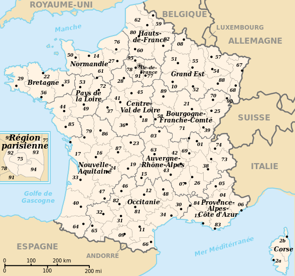
| الوصف |
 English: Departements and region of France. French geographics objects use ISO 3166-2:FR for ids.
Español: Mapa de los departamentos franceses.
Français : Départements et régions de France avec leurs préfectures. Les objects géographiques français utilisent les identifiants provenant de ISO 3166-2:FR |
||
| التاريخ | |||
| المصدر | عمل شخصي | ||
| المؤلف | bayo | ||
| الترخيص (إعادة استخدام هذا الملف) |
|
||
| إصدارات أخرى |
[]
|
![(français) Départements (numérotés) et régions de France avant 01/01/2016 (nommées, non colorisés) [source of all the following derivatives]](http://commons.wikimedia.org/wiki/File:D%C3%A9partements_et_r%C3%A9gions_de_France.svg)


![(français) Départements (numérotés) et régions de France avant 01/01/2016 (non nommées, non colorisées) [rendu amélioré] (version utilisée pour rendre la carte clicable par département)](http://commons.wikimedia.org/wiki/File:D%C3%A9partements_et_r%C3%A9gions_de_France_-_Noname-2016.svg)


![(français) Départements (numérotés) et régions de France avant 01/01/2016 (nommées et colorisées) [regions named/colored]](http://commons.wikimedia.org/wiki/File:D%C3%A9partements%2Br%C3%A9gions_(France).svg)
![(français) Départements (numérotés) et régions de France avant 01/01/2016 (nommées et colorisées) [15% magnified, rapid JPEG format 5x faster]](http://commons.wikimedia.org/wiki/File:France_departements_regions_narrow.jpg)
![(français) Départements de France (numérotés, non colorisés)[numeric labels, uncolorized]](http://commons.wikimedia.org/wiki/File:D%C3%A9partements_de_France.svg)


![(multilingue) Départements de France (sans aucun libellé) [No labels]](http://commons.wikimedia.org/wiki/File:D%C3%A9partements_et_r%C3%A9gions_de_France_vide.svg)
تاريخ الملف
اضغط على زمن/تاريخ لرؤية الملف كما بدا في هذا الزمن.
| زمن/تاريخ | صورة مصغرة | الأبعاد | مستخدم | تعليق | |
|---|---|---|---|---|---|
| حالي | 11:50، 26 أبريل 2024 | | 588 × 550 (362 كيلوبايت) | Jack ma | - correction of region limits (closing of Grand Est and Nouvelle-Aquitaine) |
| 09:02، 12 أبريل 2024 |  | 588 × 550 (438 كيلوبايت) | Jack ma | Updated French administrative regions of 2016 | |
| 16:18، 22 يوليو 2014 |  | 588 × 550 (466 كيلوبايت) | Seudo | Fixed orthograph mistake ("région parisenne") and added hyphens in Pays-de-la-Loire | |
| 02:55، 16 مايو 2009 |  | 588 × 550 (466 كيلوبايت) | Archimatth | Une seule préfecture varoise | |
| 07:26، 20 يونيو 2008 |  | 588 × 550 (467 كيلوبايت) | Bayo | patch region/departement id with ISO 3166-2:FR | |
| 09:02، 17 يونيو 2008 |  | 588 × 550 (474 كيلوبايت) | Bayo | {{Information |Description= |Source= |Date= |Author= |Permission= |other_versions= }} | |
| 16:56، 10 مايو 2008 |  | 588 × 550 (459 كيلوبايت) | Bayo | region name bigger, patch typo of some names | |
| 20:34، 22 مايو 2006 |  | 588 × 550 (459 كيلوبايت) | Bayo | patch : typo | |
| 15:11، 17 أبريل 2006 |  | 588 × 550 (459 كيلوبايت) | Bayo | ajout de l'échelle | |
| 14:45، 17 أبريل 2006 |  | 588 × 550 (455 كيلوبايت) | Bayo | *'''description''' : Départements et régions et de France avec leurs préfectures. *'''auteur''' : bayo Category:Maps of departements of France Category:Maps of régions of France == Licensing == {{PD-self}} |
استخدام الملف
لا توجد صفحات تستخدم هذا الملف.
الاستخدام العالمي للملف
الويكيات الأخرى التالية تستخدم هذا الملف:
- الاستخدام في af.wikipedia.org
- الاستخدام في ceb.wikipedia.org
- الاستخدام في da.wikipedia.org
- الاستخدام في es.wikipedia.org
- الاستخدام في eu.wikipedia.org
- الاستخدام في fi.wikipedia.org
- الاستخدام في fr.wikipedia.org
- Aménagement du territoire en France
- Discussion modèle:Fragéoloc
- Wikipédia:Atelier graphique/Images à améliorer/Archives/Novembre 2006
- Wikipédia:Atelier graphique/Images à améliorer/Archives/Mai 2007
- Discussion utilisateur:Mirondia
- Utilisateur:Wikisoft*/Tests cartes
- Discussion utilisateur:Sting/Archive 08
- Patrimoine juif d'Alsace
- Patrimoine juif de Lorraine
- Patrimoine juif du Sud-Est de la France et de la principauté de Monaco
- Patrimoine juif d'Île-de-France
- Patrimoine juif du Sud-Ouest de la France
- Patrimoine juif des régions du centre, partie ouest
- Patrimoine juif du Nord et de l'Est de la France (sauf Alsace et Lorraine)
- Patrimoine protestant de Lorraine
- الاستخدام في ia.wikipedia.org
- الاستخدام في la.wikipedia.org
- الاستخدام في lt.wikipedia.org
- الاستخدام في oc.wikipedia.org
- الاستخدام في pt.wikipedia.org
- الاستخدام في qu.wikipedia.org
- الاستخدام في se.wikipedia.org
- الاستخدام في vi.wikipedia.org