
ملف:Hvo controlled.png
الملف الأصلي (1٬220 × 1٬100 بكسل حجم الملف: 99 كيلوبايت، نوع MIME: image/png)
| هذا ملف من ويكيميديا كومنز. معلومات من صفحة وصفه مبينة في الأسفل. كومنز مستودع ملفات ميديا ذو رخصة حرة. |
ملخص
(
| الوصف |
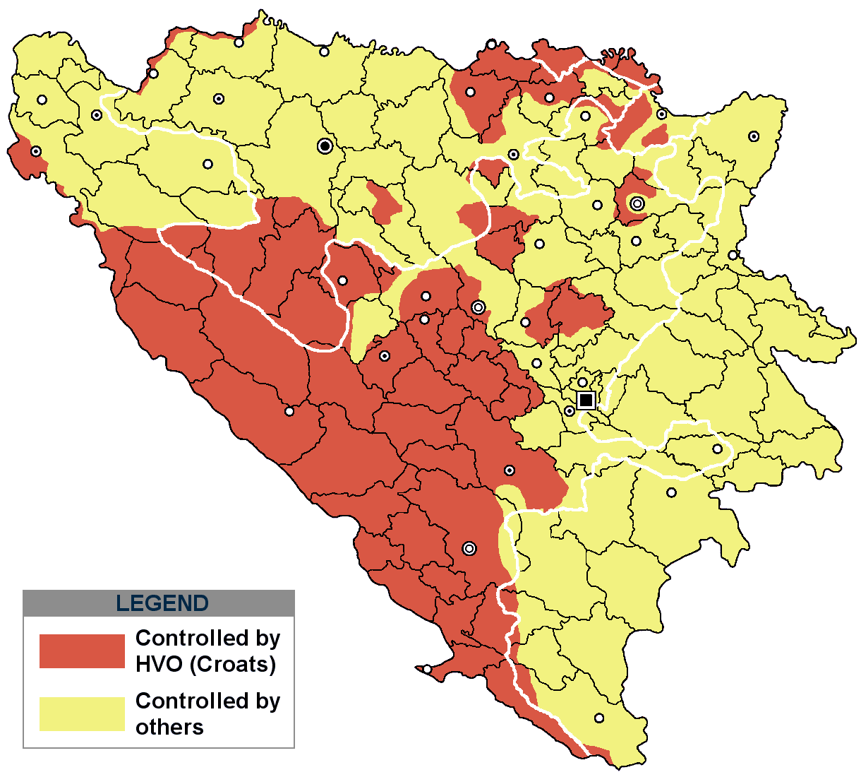
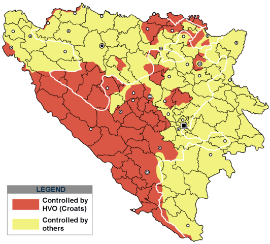
This is an update for the previous map, as the HVO never controlled all parts of municipality of Mostar and Stolac. Also, HVO never controlled neither part of municipalities Nevesinje, Berkovići, Ljubinje and Trebinje.
|
| التاريخ | |
| المصدر | self-made by Nihad Hamzić |
| المؤلف | Nihad Hamzic |
}
ترخيص
| وضع -I, Nihad Hamzic-، وهو المؤلف، هذا العمل في النِّطاق العامِّ. يسري ذلك في كل أرجاء العالم. في بعض البلدان، قد يكون هذا التَّرخيص غيرَ مُمكنٍ قانونيَّاً، في هذه الحالة: يمنح I, Nihad Hamzic الجميع حق استخدام هذا العمل لأي غرض دون أي شرط ما لم يفرض القانون شروطًا إضافية. |
The original image is here:
http://commons.wikimedia.org/wiki/Image:Hvo_controled.GIF
Check its description for licensing etc.
تاريخ الملف
اضغط على زمن/تاريخ لرؤية الملف كما بدا في هذا الزمن.
| زمن/تاريخ | صورة مصغرة | الأبعاد | مستخدم | تعليق | |
|---|---|---|---|---|---|
| حالي | 17:21، 29 نوفمبر 2020 | | 1٬220 × 1٬100 (99 كيلوبايت) | Ceha | Tuzla i Bugojno |
| 13:31، 28 نوفمبر 2020 |  | 1٬220 × 1٬100 (98 كيلوبايت) | Ceha | Dodao neke promjene, od Ravne-Brčko, do Ravnog na jugu (operacija Bura https://hr.wikipedia.org/wiki/Operacija_Bura ) | |
| 17:40، 20 يوليو 2011 |  | 1٬220 × 1٬100 (48 كيلوبايت) | DIREKTOR | Colors | |
| 09:29، 11 فبراير 2009 |  | 1٬220 × 1٬100 (49 كيلوبايت) | Ceha | Corrected errors in Komušina municipality, HVO controled all of Croatian settlments till 10th of August 1991 | |
| 08:24، 11 أغسطس 2008 |  | 1٬220 × 1٬100 (49 كيلوبايت) | Mostarac | {{Information |Description=This is an update for the previous map, as the HVO never controlled all parts of municipality of Mostar and Stolac. Also, HVO never controlled neither part of municipalities Nevesinje, Berkovići and Ljubinje. |Source=self-made | |
| 14:33، 5 يناير 2008 |  | 1٬220 × 1٬100 (49 كيلوبايت) | Nihad Hamzic | Added a legend. Also widened the image slightly to match the size of related images. I did not resize it, but added white space at sides. | |
| 10:08، 17 يوليو 2007 |  | 1٬213 × 1٬100 (41 كيلوبايت) | Nihad Hamzic | Revised the colors to match (to be uniform) with colors in other related maps. | |
| 22:31، 15 يوليو 2007 |  | 1٬213 × 1٬100 (41 كيلوبايت) | Nihad Hamzic | {{Information |Description=BiH territories which were controlled by HVO and regular Croatian Army for some time during the war. <br /> <br /> NOTICE:<br /> This image is a greatly optimised PNG version of the original GIF version of the image. Color dihte |
استخدام الملف
الصفحة التالية تستخدم هذا الملف:
الاستخدام العالمي للملف
الويكيات الأخرى التالية تستخدم هذا الملف:
- الاستخدام في ast.wikipedia.org
- الاستخدام في bs.wikipedia.org
- الاستخدام في ca.wikipedia.org
- الاستخدام في cs.wikipedia.org
- الاستخدام في de.wikipedia.org
- الاستخدام في es.wikipedia.org
- الاستخدام في eu.wikipedia.org
- الاستخدام في fr.wikipedia.org
- الاستخدام في gl.wikipedia.org
- الاستخدام في hy.wikipedia.org
- الاستخدام في hyw.wikipedia.org
- الاستخدام في it.wikipedia.org
- الاستخدام في pnb.wikipedia.org
- الاستخدام في pt.wikipedia.org
- الاستخدام في ru.wikipedia.org
- الاستخدام في sr.wikipedia.org
- الاستخدام في sv.wikipedia.org
- الاستخدام في vi.wikipedia.org