
ملف:Map of Indiana highlighting Crawford County.svg

حجم معاينة PNG لذلك الملف ذي الامتداد SVG: 391 × 599 بكسل. الأبعاد الأخرى: 156 × 240 بكسل | 313 × 480 بكسل | 501 × 768 بكسل | 668 × 1٬024 بكسل | 1٬337 × 2٬048 بكسل | 722 × 1٬106 بكسل.
الملف الأصلي (ملف SVG، أبعاده 722 × 1٬106 بكسل، حجم الملف: 42 كيلوبايت)
| هذا ملف من ويكيميديا كومنز. معلومات من صفحة وصفه مبينة في الأسفل. كومنز مستودع ملفات ميديا ذو رخصة حرة. |
ملخص
| الوصف |
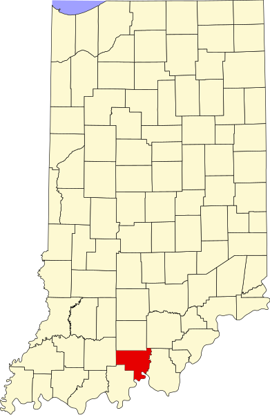
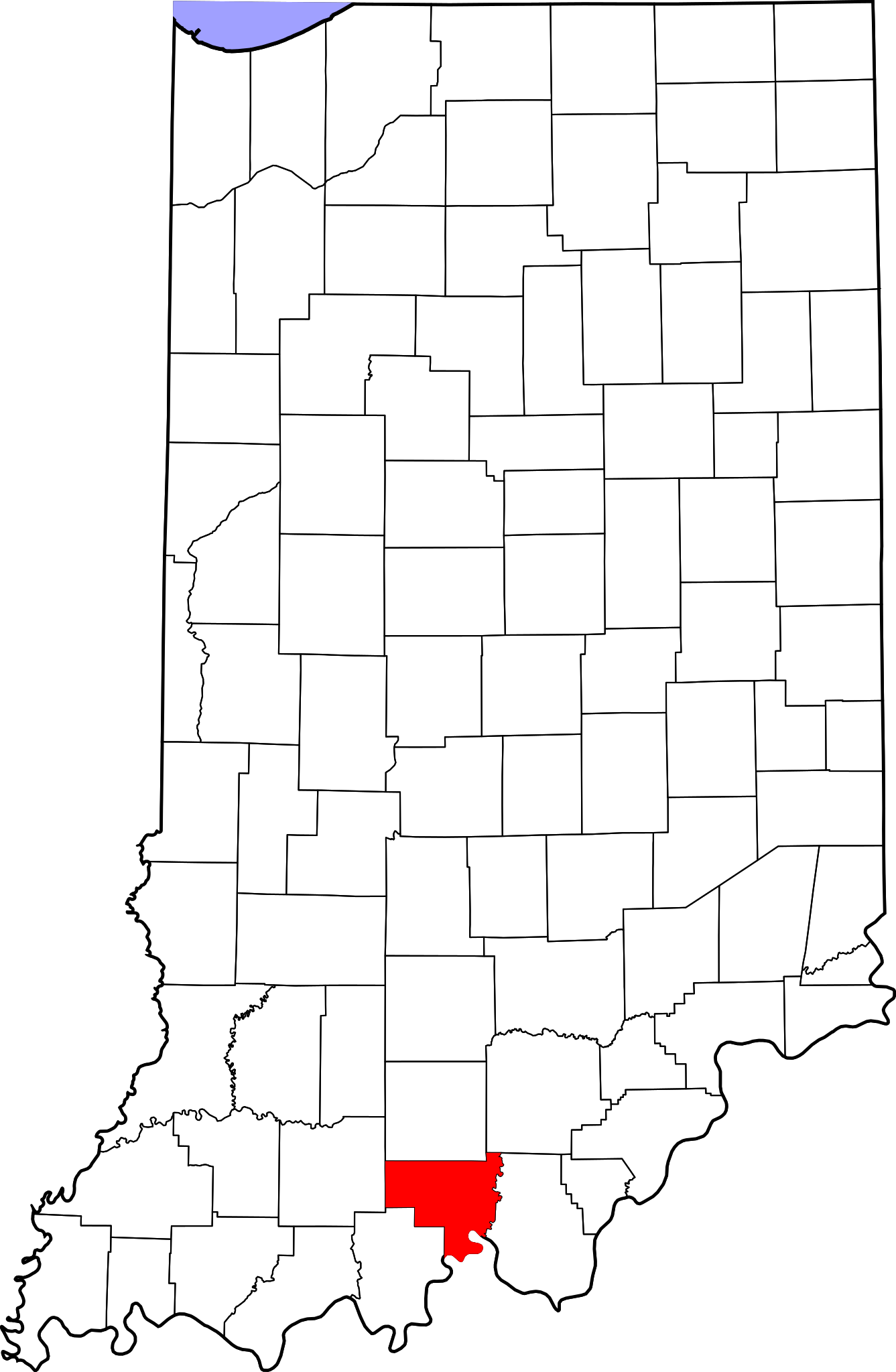
English: This is a locator map showing Crawford County in Indiana. For more information, see Commons:United States county locator maps. |
| التاريخ | |
| المصدر |
عمل شخصي: English: The maps use data from nationalatlas.gov, specifically countyp020.tar.gz on the Raw Data Download page. The maps also use state outline data from statesp020.tar.gz. The Florida maps use hydrogm020.tar.gz to display Lake Okeechobee. |
| المؤلف | David Benbennick |
ترخيص
| أنا، مالِك حقوق تأليف ونشر هذا العمل، أجعله في النِّطاق العامِّ، يسري هذا في أرجاء العالم كلِّه. في بعض البلدان، قد يكون هذا التَّرخيص غيرَ مُمكنٍ قانونيَّاً، في هذه الحالة: أمنح الجميع حق استخدام هذا العمل لأي غرض دون أي شرط ما لم يفرض القانون شروطًا إضافية. |
تاريخ الملف
اضغط على زمن/تاريخ لرؤية الملف كما بدا في هذا الزمن.
| زمن/تاريخ | صورة مصغرة | الأبعاد | مستخدم | تعليق | |
|---|---|---|---|---|---|
| حالي | 14:34، 25 يونيو 2024 | | 722 × 1٬106 (42 كيلوبايت) | Nux | uniform colors with good contrast |
| 20:38، 19 يونيو 2024 |  | 722 × 1٬106 (42 كيلوبايت) | Nux | fix rendering (remove clipping) | |
| 12:09، 12 فبراير 2006 |  | 2٬887 × 4٬423 (56 كيلوبايت) | David Benbennick | {{subst:User:Dbenbenn/clm|county=Crawford County|state=Indiana}} |
استخدام الملف
ال6 صفحات التالية تستخدم هذا الملف:
الاستخدام العالمي للملف
الويكيات الأخرى التالية تستخدم هذا الملف:
- الاستخدام في bg.wikipedia.org
- الاستخدام في bpy.wikipedia.org
- الاستخدام في cdo.wikipedia.org
- الاستخدام في ceb.wikipedia.org
- الاستخدام في ce.wikipedia.org
- الاستخدام في cy.wikipedia.org
- الاستخدام في de.wikipedia.org
- الاستخدام في en.wikipedia.org
- List of counties in Indiana
- Crawford County, Indiana
- Alton, Indiana
- English, Indiana
- Leavenworth, Indiana
- Marengo, Indiana
- Milltown, Indiana
- Taswell, Indiana
- Potts Creek Rockshelter
- Template:Crawford County, Indiana
- Boone Township, Crawford County, Indiana
- Jennings Township, Crawford County, Indiana
- Johnson Township, Crawford County, Indiana
- Liberty Township, Crawford County, Indiana
- Ohio Township, Crawford County, Indiana
- Patoka Township, Crawford County, Indiana
- Sterling Township, Crawford County, Indiana
- Union Township, Crawford County, Indiana
- Whiskey Run Township, Crawford County, Indiana
- Template:CrawfordCountyIN-geo-stub
- Eckerty, Indiana
- Cape Sandy, Indiana
- Curby, Indiana
- Grantsburg, Indiana
- Hogtown, Indiana
- Pilot Knob, Indiana
- Riddle, Indiana
- Sulphur, Indiana
- Temple, Indiana
- West Fork, Indiana
- Wickliffe, Indiana
- User:Nyttend/County templates/IN/1
- National Register of Historic Places listings in Crawford County, Indiana
- Category:Populated places in Crawford County, Indiana
- List of Indiana state historical markers in Crawford County
- Beechwood, Indiana
- Brownstown, Crawford County, Indiana
- Carefree, Indiana
- Deuchars, Indiana
- Fredonia, Indiana
- Magnolia, Indiana
- Mifflin, Indiana
- Riceville, Indiana
اعرض المزيد من الاستخدام العام لهذا الملف.