
ملف:Maricopa County Incorporated and Planning areas SRPMIC highlighted.svg

حجم معاينة PNG لذلك الملف ذي الامتداد SVG: 694 × 599 بكسل. الأبعاد الأخرى: 278 × 240 بكسل | 556 × 480 بكسل | 889 × 768 بكسل | 1٬185 × 1٬024 بكسل | 2٬371 × 2٬048 بكسل | 940 × 812 بكسل.
الملف الأصلي (ملف SVG، أبعاده 940 × 812 بكسل، حجم الملف: 1٫05 ميجابايت)
| هذا ملف من ويكيميديا كومنز. معلومات من صفحة وصفه مبينة في الأسفل. كومنز مستودع ملفات ميديا ذو رخصة حرة. |
ملخص
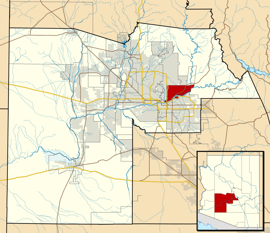
| الوصف | This map shows the incorporated areas and Indian reservation boundaries in Maricopa County, Arizona, along with water bodies and major highways and roads. The Salt River Pima Maricopa Indian Community is highlighted in red. Other incorporated cities are shown in gray, planning area borders for these cities and Indian reservation borders are shown as solid black lines. Changes from Previous Version: Updated the maps to include water bodies and to make "less boring" than the plain black/white/gray maps. Format was updated to match standards laid out by WikiProject Maps/Conventions. Map data is based on data from the following Webpage: Maricopa County Interactive GIS Map. I created this map in Inkscape. |
| التاريخ | |
| المصدر | My own work, based on government information |
| المؤلف | Ixnayonthetimmay |
| الترخيص (إعادة استخدام هذا الملف) |
Public Domain |
| إصدارات أخرى | See Category:Maps of Maricopa County for other versions of this image. |
ترخيص
| أنا، مالِك حقوق تأليف ونشر هذا العمل، أجعله في النِّطاق العامِّ، يسري هذا في أرجاء العالم كلِّه. في بعض البلدان، قد يكون هذا التَّرخيص غيرَ مُمكنٍ قانونيَّاً، في هذه الحالة: أمنح الجميع حق استخدام هذا العمل لأي غرض دون أي شرط ما لم يفرض القانون شروطًا إضافية. |
تاريخ الملف
اضغط على زمن/تاريخ لرؤية الملف كما بدا في هذا الزمن.
| زمن/تاريخ | صورة مصغرة | الأبعاد | مستخدم | تعليق | |
|---|---|---|---|---|---|
| حالي | 06:42، 20 مايو 2011 | | 940 × 812 (1٫05 ميجابايت) | Ixnayonthetimmay | Uploading new version |
| 04:42، 30 أغسطس 2008 |  | 900 × 800 (413 كيلوبايت) | Ixnayonthetimmay | == Summary == {{Information |Description=This map shows the incorporated areas and unincorporated areas in Maricopa County, Arizona. [[:en:Sentinel, Arizona| | |
| 23:48، 15 سبتمبر 2007 |  | 900 × 800 (385 كيلوبايت) | Ixnayonthetimmay | == Summary == {{Information |Description=This map shows the incorporated areas in Maricopa County, Arizona. It also shows the boundaries for the municipal planning areas. The [[:en:Fort | |
| 10:12، 28 مايو 2007 |  | 900 × 780 (330 كيلوبايت) | Ixnayonthetimmay | ||
| 01:14، 22 مايو 2007 |  | 900 × 780 (322 كيلوبايت) | Ixnayonthetimmay | ||
| 05:25، 30 يناير 2007 |  | 904 × 758 (189 كيلوبايت) | Ixnayonthetimmay | {{Information |Description=This map shows the incorporated areas in Maricopa County, Arizona, highlighting [[:w:Salt River Pima Maricopa Indian Community|Salt River Pima Maricopa Indian |
استخدام الملف
الصفحتان التاليتان تستخدمان هذا الملف:
الاستخدام العالمي للملف
الويكيات الأخرى التالية تستخدم هذا الملف:
- الاستخدام في ca.wikipedia.org
- الاستخدام في en.wikipedia.org
- الاستخدام في fr.wikipedia.org
- الاستخدام في uk.wikipedia.org