
ملف:Mars Science Laboratory landing ellipse reduced.jpg

الملف الأصلي (1٬920 × 1٬080 بكسل حجم الملف: 355 كيلوبايت، نوع MIME: image/jpeg)
| هذا ملف من ويكيميديا كومنز. معلومات من صفحة وصفه مبينة في الأسفل. كومنز مستودع ملفات ميديا ذو رخصة حرة. |
ملخص
| الوصف |
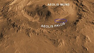
Français : Zone d'atterrissage de la sonde spatiale de la NASA Mars Science Laboratory dans le cratère Gale. La cible est l'ellipse (20x7 km) située dans une zone de plaine baptisée Aeolis Palus au pied du pic central Aeolis Mons qui culmine à 5 km au-dessus du plancher du cratère.
English: Oblique view of Gale Crater from the North
This computer-generated view based on multiple orbital observations shows Mars' Gale crater as if seen from an aircraft north of the crater. NASA has selected Gale as the landing site for the Mars Science Laboratory mission. Gale crater is 96 miles (154 kilometers) in diameter and holds a layered mountain rising about 3 miles (5 kilometers) above the crater floor. The ellipse superimposed on this image indicates the candidate landing area, 12 miles by 4 miles (20 by 7 kilometers).. The portion of the crater within the landing area has an alluvial fan likely formed by water-carried sediments. The lower layers of the nearby mountain -- within driving distance for Curiosity -- contain minerals indicating a wet history. The candidate landing site is at 4.5 degrees south latitude, 137.4 degrees east longitude. This view was created using visible-light imaging by the Thermal Emission Imaging System camera on NASA's Mars Odyssey orbiter and three-dimensional information from the Mars Orbiter Laser Altimeter, which flew on NASA's Mars Global Surveyor orbiter. Color information is generalized from color imaging of portions of the scene by the High Resolution Imaging Science Experiment camera on NASA's Mars Reconnaissance Orbiter. The vertical dimension is not exaggerated. The Mars Science Laboratory spacecraft is being prepared for launch during the period Nov. 25 to Dec. 18, 2011. In a prime mission lasting one Martian year -- nearly two Earth years -- after landing, researchers will use the rover's tools to study whether the landing region has had environmental conditions favorable for supporting microbial life and for preserving clues about whether life existed. |
| التاريخ | |
| المصدر | [1], [2] |
| المؤلف | NASA/JPL-Caltech/ASU/UA |
ترخيص
| يقع هذا العمل في النِّطاق العامّ في الولايات المُتحدة الأمريكيَّة لأَنَّه عملٌ خالِصٌ من إِنتاج وكالة الفضاء الأمريكيَّة. تنصُ حقوق التَّأليف والنَّشر الخاصَّة بوكالة الفضاء الأمريكيَّة على أنَّ "أعمال الوكالة غير مَحميَّة بحقوق التَّأليف والنَّشر ما لم يُذكر خلافُ ذلك". لمزيدٍ من المعلومات انظر القالِب {{PD-USGov}} وصفحة حقوق التَّأليف والنَّشر الخاصَّة بالوكالة وصفحة سياسة الصُّور الخاصَّة بمُختبر الدَّفع النَّفَّاث. | ||
 |
تنبيهات:
|
تاريخ الملف
اضغط على زمن/تاريخ لرؤية الملف كما بدا في هذا الزمن.
| زمن/تاريخ | صورة مصغرة | الأبعاد | مستخدم | تعليق | |
|---|---|---|---|---|---|
| حالي | 13:52، 5 أغسطس 2012 | | 1٬920 × 1٬080 (355 كيلوبايت) | Pline |
استخدام الملف
لا توجد صفحات تستخدم هذا الملف.
الاستخدام العالمي للملف
الويكيات الأخرى التالية تستخدم هذا الملف:
- الاستخدام في bg.wikipedia.org
- الاستخدام في bn.wikipedia.org
- الاستخدام في ca.wikipedia.org
- الاستخدام في cy.wikipedia.org
- الاستخدام في en.wikipedia.org
- الاستخدام في es.wikipedia.org
- الاستخدام في fa.wikipedia.org
- الاستخدام في fr.wikipedia.org
- الاستخدام في it.wikipedia.org
- الاستخدام في ja.wikipedia.org
- الاستخدام في ko.wikipedia.org
- الاستخدام في no.wikipedia.org
- الاستخدام في ru.wikipedia.org
- الاستخدام في test.wikipedia.org
- الاستخدام في tr.wikipedia.org
- الاستخدام في uk.wikipedia.org
- الاستخدام في zh.wikipedia.org