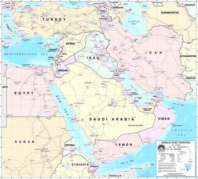
ملف:Middle east graphic 2003.jpg

حجم هذه المعاينة: 664 × 600 بكسل. الأبعاد الأخرى: 266 × 240 بكسل | 532 × 480 بكسل | 850 × 768 بكسل | 1٬134 × 1٬024 بكسل | 2٬268 × 2٬048 بكسل | 2٬973 × 2٬685 بكسل.
الملف الأصلي (2٬973 × 2٬685 بكسل حجم الملف: 3٫91 ميجابايت، نوع MIME: image/jpeg)
تاريخ الملف
اضغط على زمن/تاريخ لرؤية الملف كما بدا في هذا الزمن.
| زمن/تاريخ | صورة مصغرة | الأبعاد | مستخدم | تعليق | |
|---|---|---|---|---|---|
| حالي | 22:30، 8 فبراير 2012 |  | 2٬973 × 2٬685 (3٫91 ميجابايت) | M0tty | Remove compression artefacts by a bilateral filtering. |
| 21:43، 14 يوليو 2006 |  | 2٬973 × 2٬685 (1٬013 كيلوبايت) | Unquietwiki | ''Courtesy of the University of Texas Libraries, The University of Texas at Austin'' [http://www.lib.utexas.edu/maps/middle_east.html http://www.lib.utexas.edu/maps/middle_east.html] High-resolution political / railway / roadmap of the Middle East. |
استخدام الملف
ال24 صفحة التالية تستخدم هذا الملف:
- أبجر التاسع
- الحويزة (مدينة)
- بادية الشام
- خليج عدن
- دزفول
- زاغروس
- زاينده
- شرف الدين بن الحسن
- شرق المتوسط
- صخر بن صخر بن مسافر
- عبد الله بن سعيد
- فخر الدين بن عدي
- قائمة جزر الخليج العربي
- قائمة نزاعات الشرق الأوسط الحديثة
- قرار مجلس الأمن التابع للأمم المتحدة رقم 1381
- محافظة العاصمة (البحرين)
- مسجد سليمان
- مسرح أحداث الشرق الأوسط خلال الحرب العالمية الثانية
- مستخدم:ASammour/بذرة-بوابة
- مستخدم:Adnanzoom/مساعدات
- ويكيبيديا:قوالب/بذور
- ويكيبيديا:قوالب/بذور/جدول بذرة 1
- قالب:بذرة أعلام الشرق الأوسط
- قالب:بذرة جغرافيا الشرق الأوسط
الاستخدام العالمي للملف
الويكيات الأخرى التالية تستخدم هذا الملف:
- الاستخدام في arz.wikipedia.org
- الاستخدام في ba.wikipedia.org
- الاستخدام في be.wikipedia.org
- الاستخدام في bn.wikipedia.org
- الاستخدام في ca.wikipedia.org
- الاستخدام في ce.wikipedia.org
- الاستخدام في ckb.wikipedia.org
- الاستخدام في el.wikipedia.org
- الاستخدام في en.wikipedia.org
- Talk:Arabic
- Talk:Cyprus
- Talk:Persian language
- Talk:Israel
- Talk:Knights Templar
- Talk:Nostratic languages
- Talk:Palestine (region)
- Talk:Palestinian National Authority
- Talk:Romani people
- Talk:West Bank
- Talk:Gulf War
- Talk:Jews
- Talk:Zoroastrianism
- Talk:Gaza Strip
- Talk:Syria
- Talk:Georgia (country)
- Talk:History of Cyprus
- Talk:Palestinian territories
- Talk:Ancient Egyptian religion
- Talk:Antiphonitis
- Talk:Historicity of the Bible
- Talk:History of Kuwait
- Talk:Gulf War (disambiguation)
- Talk:Suez Canal
- Talk:Kurdistan
- Talk:Esau
- Talk:U.S. list of most-wanted Iraqis
- Talk:George Michael
- Talk:Crusader states
- Talk:Swahili language
- Talk:State of Palestine
- Talk:Golan Heights
- Talk:Ali Hassan al-Majid
- Talk:Aladdin
- Talk:Daniel Pipes
- Talk:Northern Cyprus
- Talk:Saudi Arabia
- Talk:Egypt
اعرض المزيد من الاستخدام العام لهذا الملف.


