
ملف:Mtcook.nz.750pix.jpg
حجم هذه المعاينة: 650 × 600 بكسل. الأبعاد الأخرى: 260 × 240 بكسل | 520 × 480 بكسل | 832 × 768 بكسل | 1٬110 × 1٬024 بكسل | 2٬219 × 2٬048 بكسل | 6٬108 × 5٬637 بكسل.
الملف الأصلي (6٬108 × 5٬637 بكسل حجم الملف: 4٫66 ميجابايت، نوع MIME: image/jpeg)
| هذا ملف من ويكيميديا كومنز. معلومات من صفحة وصفه مبينة في الأسفل. كومنز مستودع ملفات ميديا ذو رخصة حرة. |
ملخص
| الوصف |
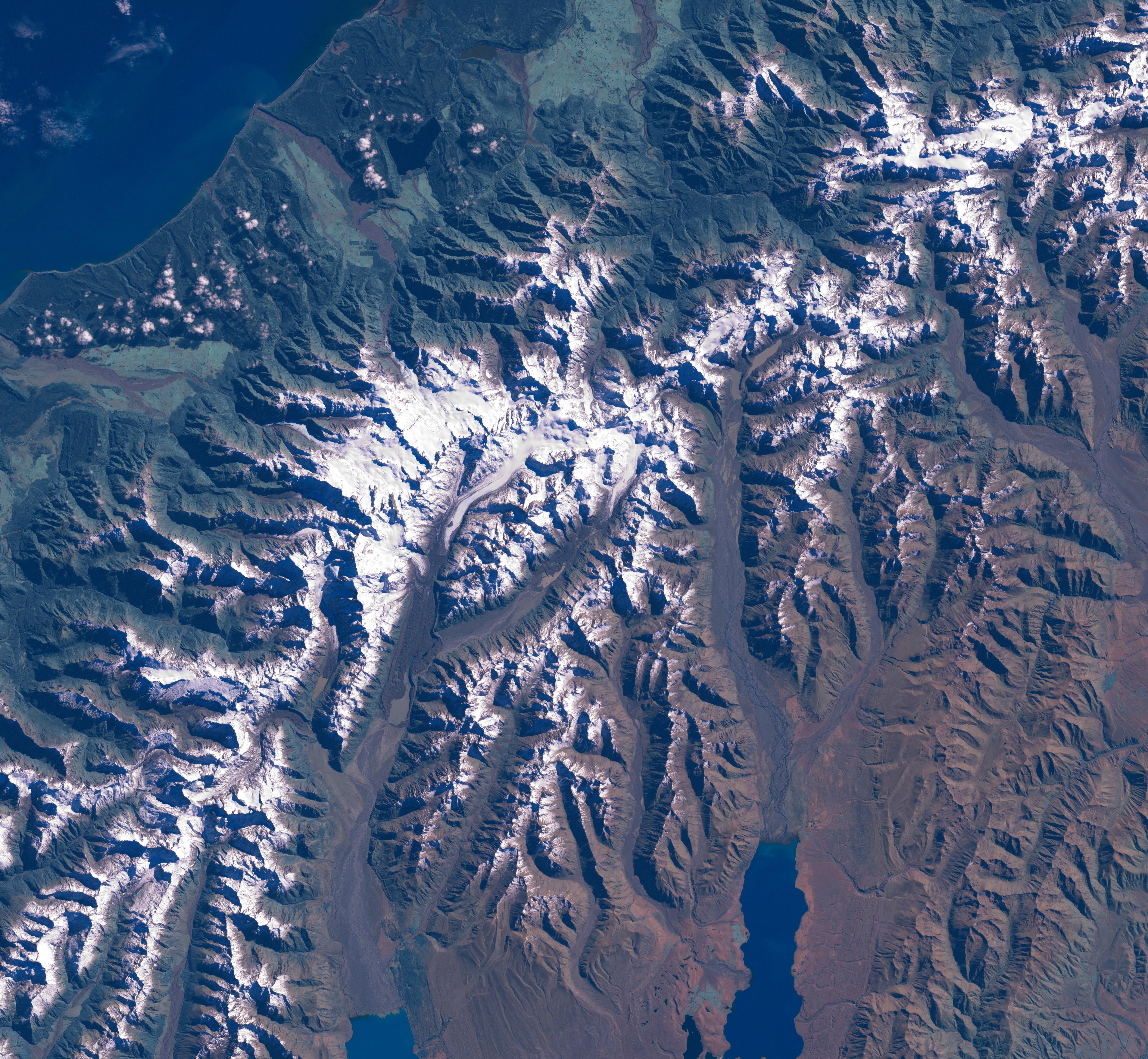
The Aoraki/Mount Cook area from LandSat. This image was acquired by Landsat 7's Enhanced Thematic Mapper plus (ETM ) sensor on March 31, 2001. This is a true-color image made using red, green, and blue wavelengths (ETM bands 3, 2, and 1). The image has also been pan-sharpened to heighten the details and resolution. |
| المصدر |
SOURCE:
http://earthobservatory.nasa.gov/Newsroom/NewImages/images.php3?img_id=15331
This image was acquired by Landsat 7's Enhanced Thematic Mapper plus (ETM ) sensor on March 31, 2001. This is a true-color image made using red, green, and blue wavelengths (ETM bands 3, 2, and 1). The image has also been pan-sharpened to heighten the details and resolution. ”The purpose of NASA's Earth Observatory is to provide a freely-accessible publication on the Internet where the public can obtain new satellite imagery and scientific information about our home planet. The focus is on Earth's climate and environmental change. In particular, we hope our site is useful to public media and educators. Any and all materials published on the Earth Observatory are freely available for re-publication or re-use, except where copyright is indicated. We ask that NASA's Earth Observatory be given credit for its original materials.” |
| المؤلف | Picture prepared for Wikipedia by Adrian Pingstone in November 2003. |
| الترخيص (إعادة استخدام هذا الملف) |
PD |
Original authors
- Source: en.wikipedia.org
- Upload Tool Operator: Flominator (Flominator)
- Image contributor(s): Arpingstone
- 17:49, 7 November 2003 Arpingstone 750×750 (116,804 bytes) (Mount Cook from LandSat)
ترخيص
| يقع هذا العمل في النِّطاق العامّ في الولايات المُتحدة الأمريكيَّة لأَنَّه عملٌ خالِصٌ من إِنتاج وكالة الفضاء الأمريكيَّة. تنصُ حقوق التَّأليف والنَّشر الخاصَّة بوكالة الفضاء الأمريكيَّة على أنَّ "أعمال الوكالة غير مَحميَّة بحقوق التَّأليف والنَّشر ما لم يُذكر خلافُ ذلك". لمزيدٍ من المعلومات انظر القالِب {{PD-USGov}} وصفحة حقوق التَّأليف والنَّشر الخاصَّة بالوكالة وصفحة سياسة الصُّور الخاصَّة بمُختبر الدَّفع النَّفَّاث. | ||
 |
تنبيهات:
|
تاريخ الملف
اضغط على زمن/تاريخ لرؤية الملف كما بدا في هذا الزمن.
| زمن/تاريخ | صورة مصغرة | الأبعاد | مستخدم | تعليق | |
|---|---|---|---|---|---|
| حالي | 16:20، 24 فبراير 2007 | | 6٬108 × 5٬637 (4٫66 ميجابايت) | Tom | higher res and w/o english words |
| 08:32، 29 أغسطس 2006 |  | 750 × 750 (114 كيلوبايت) | CommonismNow | {{Information| |Description=This image was acquired by Landsat 7's Enhanced Thematic Mapper plus (ETM ) sensor on March 31, 2001. This is a true-color image made using red, green, and blue wavelengths (ETM bands 3, 2, and 1). The image has also been pan- |
استخدام الملف
الصفحة التالية تستخدم هذا الملف:
الاستخدام العالمي للملف
الويكيات الأخرى التالية تستخدم هذا الملف:
- الاستخدام في bg.wikipedia.org
- الاستخدام في bn.wikipedia.org
- الاستخدام في ca.wikipedia.org
- الاستخدام في cy.wikipedia.org
- الاستخدام في da.wikipedia.org
- الاستخدام في de.wikipedia.org
- الاستخدام في en.wikipedia.org
- الاستخدام في es.wikipedia.org
- الاستخدام في eu.wikipedia.org
- الاستخدام في hr.wikipedia.org
- الاستخدام في ja.wikipedia.org
- الاستخدام في mt.wikipedia.org
- الاستخدام في nn.wikipedia.org
- الاستخدام في pt.wikipedia.org
- الاستخدام في sh.wikipedia.org
- الاستخدام في sl.wikipedia.org