
ملف:Negroland and Guinea with the European Settlements, 1736.jpg

الملف الأصلي (1٬200 × 894 بكسل حجم الملف: 1٫55 ميجابايت، نوع MIME: image/jpeg)
| هذا ملف من ويكيميديا كومنز. معلومات من صفحة وصفه مبينة في الأسفل. كومنز مستودع ملفات ميديا ذو رخصة حرة. |
Map|thumb|alt=https://www.canva.com/design/DAEqyLnPwRY/share/preview?token=KSHUFcVdAgta6UUstYCF7w&role=EDITOR&utm_content=DAEqyLnPwRY&utm_campaign=designshare&utm_medium=link&utm_source=sharebutton%7CThis 1747 Map reflects the various Kingdoms. The Kingdom of Juda(h). Ouidah /ˈwiːdə/, also Whydah /ˈhwaɪdə/ ]]
ملخص
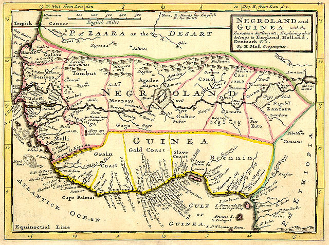
| الوصف | Full title: 'Negroland and Guinea with the European Settlements, Explaining what belongs to England, Holland, Denmark, etc'. By H. Moll Geographer (Printed and sold by T. Bowles next ye Chapter House in St. Pauls Church yard, & I. Bowles at ye Black Horse in Cornhill, 1729, orig. published in 1727). [1] |
| التاريخ | |
| المصدر | University of Florida, George A. Smathers Libraries, historic African maps: 1729 Herman Moll (#ALW1663) |
| المؤلف | Herman Moll |
ترخيص
|
هذا العمل يقع في النَّطاق العامّ في بلد المنشأ وفي البلدان الأخرى والمناطق التي تمتدُّ فيها مدة حقوق التَّأليف والنشر لتغطي زمن حياة المُؤلِّف و 100 سنةً بعد وفاته أو أقل من ذلك. | |
| هذا الملفُّ مَلحُوظُ بصفته غيرَ مُقيَّدٍ بحقوق التَّأليف والنشر، وهذا يشمل أيضاً الحقوق المُجاوِرة أَو ذات الصلة جميعُها. | |
سجلُّ الرَّفع الأصيل
(All user names refer to en.wikipedia)
- 2006-06-13 23:18 LIL T 1200×894×8 (1624023 bytes)
تاريخ الملف
اضغط على زمن/تاريخ لرؤية الملف كما بدا في هذا الزمن.
| زمن/تاريخ | صورة مصغرة | الأبعاد | مستخدم | تعليق | |
|---|---|---|---|---|---|
| حالي | 06:16، 3 فبراير 2008 | | 1٬200 × 894 (1٫55 ميجابايت) | BetacommandBot | move approved by: User:Dcoetzee This image was moved from Image:ALW1663L.jpg {{Information |Description=Full title: 'Negroland and Guinea with the European Settlements, Explaining what belongs to England, Holland, Denmark, etc'. By [[:en:Herman |
استخدام الملف
ال7 صفحات التالية تستخدم هذا الملف:
الاستخدام العالمي للملف
الويكيات الأخرى التالية تستخدم هذا الملف:
- الاستخدام في an.wikipedia.org
- الاستخدام في ba.wikipedia.org
- الاستخدام في be.wikipedia.org
- الاستخدام في bn.wikipedia.org
- الاستخدام في br.wikipedia.org
- الاستخدام في bs.wikipedia.org
- الاستخدام في ca.wikipedia.org
- الاستخدام في ceb.wikipedia.org
- الاستخدام في cs.wikipedia.org
- الاستخدام في cv.wikipedia.org
- الاستخدام في da.wikipedia.org
- الاستخدام في de.wikipedia.org
- الاستخدام في en.wikipedia.org
- الاستخدام في eo.wikipedia.org
- الاستخدام في es.wikipedia.org
- الاستخدام في eu.wikipedia.org
- الاستخدام في fa.wikipedia.org
- الاستخدام في fi.wikipedia.org
- الاستخدام في fr.wikipedia.org
- الاستخدام في fr.wiktionary.org
- الاستخدام في fy.wikipedia.org
- الاستخدام في gl.wikipedia.org
- الاستخدام في ha.wikipedia.org
- الاستخدام في he.wikipedia.org
- الاستخدام في hi.wikipedia.org
اعرض المزيد من الاستخدام العام لهذا الملف.