
ملف:Netzarim junction map.png
حجم هذه المعاينة: 557 × 599 بكسل. الأبعاد الأخرى: 223 × 240 بكسل | 446 × 480 بكسل | 674 × 725 بكسل.
الملف الأصلي (674 × 725 بكسل حجم الملف: 82 كيلوبايت، نوع MIME: image/png)
| هذا ملف من ويكيميديا كومنز. معلومات من صفحة وصفه مبينة في الأسفل. كومنز مستودع ملفات ميديا ذو رخصة حرة. |
ملخص

|
هذه locator map الصورة / الصورتان باستعمال رسومات متجهية ملفات رسوميات شعاعية.
It is recommended to name the SVG file "Netzarim junction map.svg" - then the template Vector version available (or Vva) does not need the new image name parameter.
|
| الوصف |
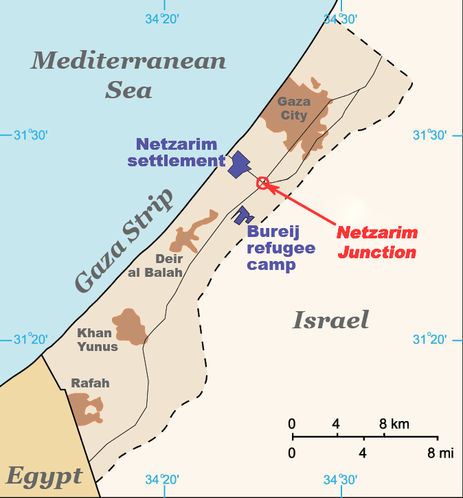
English: Map of the Gaza Strip indicating the locations of Bureij refugee camp, the former Netzarim settlement and the Netzarim Junction. Based on :Image:Gaza Strip map blank.svg. |
| التاريخ | |
| المصدر | عمل شخصي (Original text: I created this work entirely by myself.) |
| المؤلف | ChrisO (talk) |
ترخيص
Vanished user 03 في ويكيبيديا الإنجليزية، صاحب حقوق التأليف والنشر لهذا العمل، أنشر هذا العمل تحت الرخصة التالية:
هذا الملفُّ مُرخَّص بموجب رخصة المشاع الإبداعي نسبة المُصنَّف إِلى مُؤَلِّفه - المشاركة بالمثل 3.0 العامة
نسب العمل لمُؤَلِّفه: Vanished user 03 في ويكيبيديا الإنجليزية
- يحقُّ لك:
- مشاركة العمل – نسخ العمل وتوزيعه وبثُّه
- إعادة إنتاج العمل – تعديل العمل
- حسب الشروط التالية:
- نسب العمل إلى مُؤَلِّفه – يلزم نسب العمل إلى مُؤَلِّفه بشكل مناسب وتوفير رابط للرخصة وتحديد ما إذا أجريت تغييرات. بالإمكان القيام بذلك بأية طريقة معقولة، ولكن ليس بأية طريقة تشير إلى أن المرخِّص يوافقك على الاستعمال.
- الإلزام بترخيص المُشتقات بالمثل – إذا أعدت إنتاج المواد أو غيرت فيها، فيلزم أن تنشر مساهماتك المُشتقَّة عن الأصل تحت ترخيص الأصل نفسه أو تحت ترخيص مُتوافِقٍ معه.
سجلُّ الرَّفع الأصيل
نُقِلت من en.wikipedia إلى كُومُنز بواسطة Magnus Manske باستخدام CommonsHelper.
صفحة الوصف الأصلية كانت هنا، تشير جميع أسماء المستخدمين التالية إلى en.wikipedia.
- 2009-04-06 19:56 Jaakobou 674×725× (84061 bytes) Update by adding a marking and fixing colors to emphasize the junction where the al-Durrah event occurred.
- 2008-07-18 18:52 Vanished user 03 674×725× (28831 bytes) {{Information |Description=Map of the Gaza Strip indicating the locations of Bureij refugee camp, the former Netzarim settlement and the Netzarim Junction. Based on [[:Image:Gaza Strip map blank.svg]]. |Source=I created this work entirely by myself. |Date
تاريخ الملف
اضغط على زمن/تاريخ لرؤية الملف كما بدا في هذا الزمن.
| زمن/تاريخ | صورة مصغرة | الأبعاد | مستخدم | تعليق | |
|---|---|---|---|---|---|
| حالي | 16:08، 19 فبراير 2011 | | 674 × 725 (82 كيلوبايت) | File Upload Bot (Magnus Manske) | {{BotMoveToCommons|en.wikipedia|year={{subst:CURRENTYEAR}}|month={{subst:CURRENTMONTHNAME}}|day={{subst:CURRENTDAY}}}} {{Information |Description={{en|Map of the Gaza Strip indicating the locations of Bureij refugee camp, the former Netzarim settlement a |
استخدام الملف
لا توجد صفحات تستخدم هذا الملف.
الاستخدام العالمي للملف
الويكيات الأخرى التالية تستخدم هذا الملف:
- الاستخدام في cy.wikipedia.org
- الاستخدام في en.wikipedia.org
- الاستخدام في es.wikipedia.org
- الاستخدام في he.wikipedia.org
- الاستخدام في id.wikipedia.org
- الاستخدام في pnb.wikipedia.org
- الاستخدام في ru.wikipedia.org
- الاستخدام في uk.wikipedia.org
- الاستخدام في ur.wikipedia.org
- الاستخدام في uz.wikipedia.org
- الاستخدام في vi.wikipedia.org
- الاستخدام في zh.wikipedia.org