
ملف:ReliefUSA map.gif
لا توجد دقة أعلى متوفرة.
ReliefUSA_map.gif (714 × 496 بكسل حجم الملف: 228 كيلوبايت، نوع MIME: image/gif)
| هذا ملف من ويكيميديا كومنز. معلومات من صفحة وصفه مبينة في الأسفل. كومنز مستودع ملفات ميديا ذو رخصة حرة. |
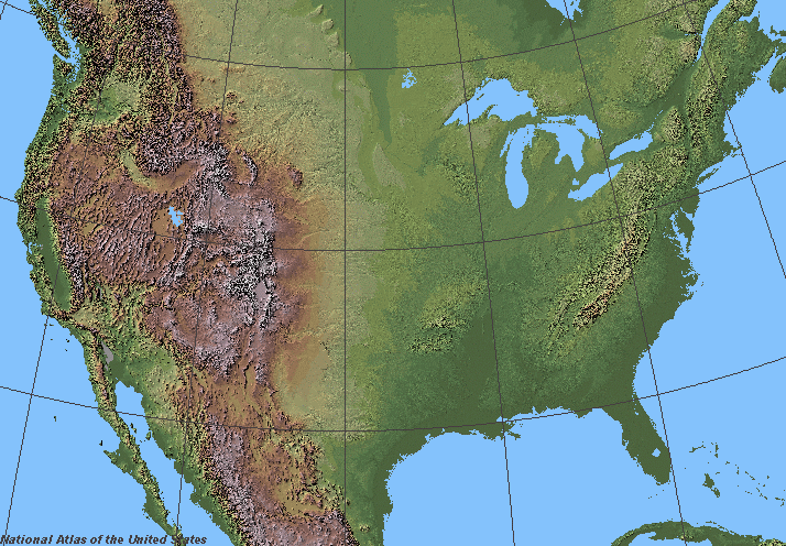
ملخص
Shaded relief in the lower 48 states of the United States of America.
ترخيص
This map was obtained from an edition of the National Atlas of the United States. Like almost all works of the U.S. federal government, works from the National Atlas are in the public domain in the United States.
Online access: NationalAtlas.gov | 1970 print edition: Library of Congress, Perry-Castañeda Library
|
derivative works
أَعمالٌ مُشتقَّة مِن هذا الملفِّ:
تاريخ الملف
اضغط على زمن/تاريخ لرؤية الملف كما بدا في هذا الزمن.
| زمن/تاريخ | صورة مصغرة | الأبعاد | مستخدم | تعليق | |
|---|---|---|---|---|---|
| حالي | 06:07، 5 يونيو 2006 | | 714 × 496 (228 كيلوبايت) | Urban~commonswiki | ==Description== Shaded relief in the lower 48 states of the United States of America. ==License== {{PD-USGov-Atlas}} |
استخدام الملف
لا توجد صفحات تستخدم هذا الملف.
الاستخدام العالمي للملف
الويكيات الأخرى التالية تستخدم هذا الملف:
- الاستخدام في fr.wikipedia.org
- Wikipédia:Wikiconcours/mars 2008/Équipes
- Discussion Wikipédia:Wikiconcours/mars 2008/Équipes/Équipe 10
- Discussion Wikipédia:Wikiconcours/mars 2008/Équipes/Équipe 10/Mammoth
- Discussion Wikipédia:Wikiconcours/mars 2008/Équipes/Équipe 10/Denver
- Discussion Wikipédia:Wikiconcours/mars 2008/Équipes/Équipe 10/Baltimore
- Discussion Wikipédia:Wikiconcours/mars 2008/Équipes/Équipe 10/Glacier
- Discussion Wikipédia:Wikiconcours/mars 2008/Équipes/Équipe 10/Modèle
- Discussion Wikipédia:Wikiconcours/mars 2008/Équipes/Équipe 10/Louisville
- الاستخدام في sco.wikipedia.org
- الاستخدام في sl.wikipedia.org