
ملف:Vancouver de.png
حجم هذه المعاينة: 800 × 574 بكسل. الأبعاد الأخرى: 320 × 230 بكسل | 640 × 459 بكسل | 1٬024 × 735 بكسل | 1٬280 × 919 بكسل | 1٬666 × 1٬196 بكسل.
الملف الأصلي (1٬666 × 1٬196 بكسل حجم الملف: 4٫02 ميجابايت، نوع MIME: image/png)
| هذا ملف من ويكيميديا كومنز. معلومات من صفحة وصفه مبينة في الأسفل. كومنز مستودع ملفات ميديا ذو رخصة حرة. |
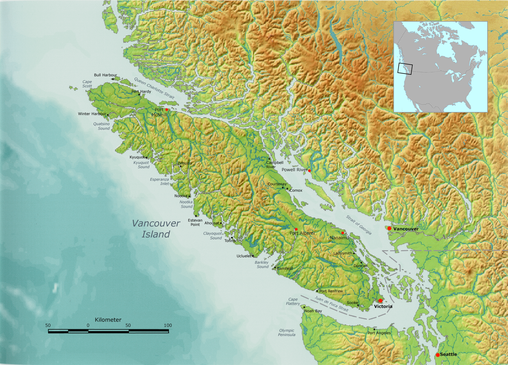
| الوصف | Vancouver Island, as well as the Canada-US border. | ||||
| التاريخ | |||||
| المصدر | Own work by Nikater, submitted to the public domain. Background map courtesy of Demis, www.demis.nl. | ||||
| المؤلف | User:Nikater | ||||
| الترخيص (إعادة استخدام هذا الملف) |
|
||||
| إصدارات أخرى | أَعمالٌ مُشتقَّة مِن هذا الملفِّ: Vancouver Island, with Lasqueti Island highlighted.png |
تاريخ الملف
اضغط على زمن/تاريخ لرؤية الملف كما بدا في هذا الزمن.
| زمن/تاريخ | صورة مصغرة | الأبعاد | مستخدم | تعليق | |
|---|---|---|---|---|---|
| حالي | 09:29، 6 أكتوبر 2007 | | 1٬666 × 1٬196 (4٫02 ميجابايت) | Nikater | {{Information |Description=Vancouver Island |Source=Own work by Nikater, submitted to the public domain. Background map courtesy of Demis, www.demis.nl. |Date=6 October 2007 |Author=User:Nikater |Permission={{PD-Demis}} }} |
استخدام الملف
الصفحة التالية تستخدم هذا الملف:
الاستخدام العالمي للملف
الويكيات الأخرى التالية تستخدم هذا الملف:
- الاستخدام في af.wikipedia.org
- الاستخدام في ast.wikipedia.org
- الاستخدام في bg.wikipedia.org
- الاستخدام في bn.wikipedia.org
- الاستخدام في br.wikipedia.org
- الاستخدام في ca.wikipedia.org
- الاستخدام في cs.wikipedia.org
- الاستخدام في da.wikipedia.org
- الاستخدام في de.wikipedia.org
- الاستخدام في en.wikipedia.org
- الاستخدام في eo.wikipedia.org
- الاستخدام في es.wikipedia.org
- Isla de Vancouver
- Estrecho de Juan de Fuca
- Islas del Golfo
- Islas San Juan
- Estrecho de Haro
- Expedición Vancouver
- Islas Discovery
- Estrecho de Johnstone
- José María Narváez
- Estrecho Rosario
- Pasaje Discovery
- Bute Inlet
- Knight Inlet
- Estrecho de la Reina Carlota
- Toba Inlet
- Barkley Sound
- Canal Cordero
- Archipiélago Broughton
- Mar de los Salish
- الاستخدام في fi.wikipedia.org
- الاستخدام في fy.wikipedia.org
- الاستخدام في gl.wikipedia.org
- الاستخدام في hr.wikipedia.org
- الاستخدام في hu.wikipedia.org
- الاستخدام في hy.wikipedia.org
اعرض المزيد من الاستخدام العام لهذا الملف.