
ملف:Waterpocket Fold - Looking south from the Strike Valley Overlook.jpg
لا توجد دقة أعلى متوفرة.
Waterpocket_Fold_-_Looking_south_from_the_Strike_Valley_Overlook.jpg (800 × 600 بكسل حجم الملف: 592 كيلوبايت، نوع MIME: image/jpeg)
| هذا ملف من ويكيميديا كومنز. معلومات من صفحة وصفه مبينة في الأسفل. كومنز مستودع ملفات ميديا ذو رخصة حرة. |
| الوصف |
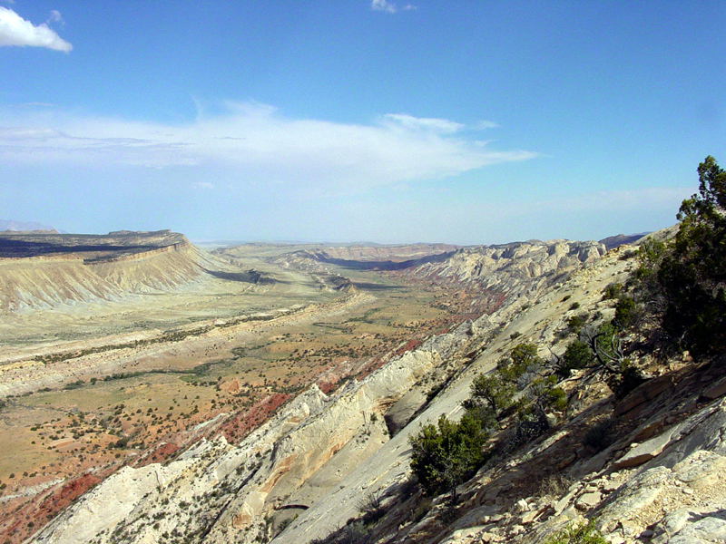
English: Perhaps the most amazing view in the region is this scene looking south from the Strike Valley Overlook along a great, warping arc in the greater Waterpocket Fold. The scene encompasses about a 2 kilometer thick section of sedimentary rocks and landscape features representing more than 200 million years of earth surface processes and conditions. The oldest sedimentary rocks on the right (the Navajo Sandstone) represents a great blanket of desert dunes that extended across the region at the close of Triassic time. Morrison Formation in the center represents the changes in Jurassic time when the great dune fields gave way to coastal floodplains, swamps, and shallow inland seas. The Mancos Shale represents the formation of a great inland Western Interior Seaway that lasted in the region through almost all of Cretaceous time. Finally this seaway withdrew at the close of Cretaceous time, the land rose, and volcanoes of the Henry Mountains formed in early Tertiary time (probably during the Oligocene Epoch between 37 and 24 million years ago). Since middle Tertiary time, the land has been steadily rising and eroding, perhaps at an increasing rate with the development of the modern Colorado River system across the region. |
|||
| التاريخ | ٨ أغسطس ٢٠٠٣ (وفقاً لبيانات تنسيق ملفِّ الصُّورة المُتبادَلة (Exif)) | |||
| المصدر | USGS – 3dparks.wr.usgs.gov | |||
| المؤلف | غير معروف | |||
| الترخيص (إعادة استخدام هذا الملف) |
|
تاريخ الملف
اضغط على زمن/تاريخ لرؤية الملف كما بدا في هذا الزمن.
| زمن/تاريخ | صورة مصغرة | الأبعاد | مستخدم | تعليق | |
|---|---|---|---|---|---|
| حالي | 03:05، 16 مارس 2006 | | 800 × 600 (592 كيلوبايت) | Mav | USGS image from [http://3dparks.wr.usgs.gov/capitol2/html/3d4665.html] Perhaps the most amazing view in the region is this scene looking south from the Strike Valley Overlook along a great, warping arc in the greater Waterpocket Fold. The scene encompass |
استخدام الملف
ال3 صفحات التالية تستخدم هذا الملف:
الاستخدام العالمي للملف
الويكيات الأخرى التالية تستخدم هذا الملف:
- الاستخدام في bg.wikipedia.org
- الاستخدام في en.wikipedia.org
- الاستخدام في es.wikipedia.org
- الاستخدام في fr.wikipedia.org
- الاستخدام في gl.wikipedia.org
- الاستخدام في ja.wikipedia.org
- الاستخدام في lt.wikipedia.org
- الاستخدام في tr.wikipedia.org