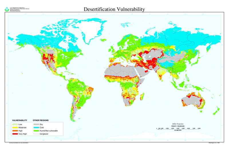
ملف:Desertification map.png
المظهر

حجم هذه المعاينة: 800 × 518 بكسل. الأبعاد الأخرى: 320 × 207 بكسل | 640 × 414 بكسل | 1٬024 × 663 بكسل | 1٬280 × 828 بكسل | 2٬560 × 1٬656 بكسل | 6٬800 × 4٬400 بكسل.
الملف الأصلي (6٬800 × 4٬400 بكسل حجم الملف: 1٫04 ميجابايت، نوع MIME: image/png)
تاريخ الملف
اضغط على زمن/تاريخ لرؤية الملف كما بدا في هذا الزمن.
| زمن/تاريخ | صورة مصغرة | الأبعاد | مستخدم | تعليق | |
|---|---|---|---|---|---|
| حالي | 11:01، 27 مارس 2022 |  | 6٬800 × 4٬400 (1٫04 ميجابايت) | No.cilepogača | Reverted to version as of 00:12, 8 November 2006 (UTC) |
| 05:11، 8 نوفمبر 2006 |  | 1٬700 × 1٬100 (558 كيلوبايت) | Paleorthid | {{Information |Description=Global Desertification Vulnerability Map |Source=http://soils.usda.gov/use/worldsoils/mapindex/desert-map.zip |Date=1998 |Author=USDA employee |Permission=This image is a work of a United States Department of Agriculture employe | |
| 00:12، 8 نوفمبر 2006 |  | 6٬800 × 4٬400 (1٫04 ميجابايت) | Paleorthid | {{Information |Description=Global Desertification Vulnerability Map |Source=http://soils.usda.gov/use/worldsoils/mapindex/desert-map.zip |Date=1998 |Author=USDA employee |Permission=This image is a work of a United States Department of Agriculture employe |
استخدام الملف
الصفحة التالية تستخدم هذا الملف:
الاستخدام العالمي للملف
الويكيات الأخرى التالية تستخدم هذا الملف:
- الاستخدام في az.wikipedia.org
- الاستخدام في bg.wikipedia.org
- الاستخدام في bn.wikipedia.org
- الاستخدام في bo.wikipedia.org
- الاستخدام في ca.wikinews.org
- الاستخدام في ckb.wikipedia.org
- الاستخدام في cs.wikipedia.org
- الاستخدام في da.wikipedia.org
- الاستخدام في de.wikipedia.org
- الاستخدام في de.wiktionary.org
- الاستخدام في el.wikipedia.org
- الاستخدام في en.wikipedia.org
- الاستخدام في eo.wikipedia.org
- الاستخدام في es.wikipedia.org
- الاستخدام في eu.wikipedia.org
- الاستخدام في fa.wikipedia.org
- الاستخدام في fi.wikipedia.org
- الاستخدام في fr.wikipedia.org
- الاستخدام في fr.wikinews.org
- الاستخدام في ga.wikipedia.org
- الاستخدام في he.wikipedia.org
- الاستخدام في hu.wikipedia.org
- الاستخدام في hy.wikipedia.org
- الاستخدام في id.wikipedia.org
- الاستخدام في is.wikipedia.org
- الاستخدام في it.wikipedia.org
- الاستخدام في ja.wikipedia.org
اعرض المزيد من الاستخدام العام لهذا الملف.

