
ملف:Misak-i milli.png

حجم هذه المعاينة: 800 × 493 بكسل. الأبعاد الأخرى: 320 × 197 بكسل | 640 × 395 بكسل | 1٬024 × 631 بكسل | 1٬474 × 909 بكسل.
الملف الأصلي (1٬474 × 909 بكسل حجم الملف: 204 كيلوبايت، نوع MIME: image/png)
| هذا ملف من ويكيميديا كومنز. معلومات من صفحة وصفه مبينة في الأسفل. كومنز مستودع ملفات ميديا ذو رخصة حرة. |
ملخص
| الوصف |
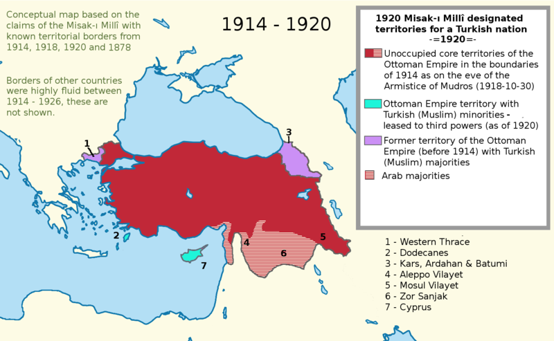
English: I worked more on the proposal map and I also added the current territories. This map shows the goal of the Turkish side. I used a Wikipedia map while I was working on this project. It is called "LocationTurkey2". --Please help me erasing the older one (Misak-ı_milli.PNG)--
Turkish variation: File:Misak-i_milli_tr.png |
| التاريخ | ٢٣ فبراير ٢٠٠٧ (تاريخ الرفع الأصيل) |
| المصدر | نُقِلت من en.wikipedia إلى كُومُنز . |
| المؤلف | Deliogul في ويكيبيديا الإنجليزية |
ترخيص
Deliogul من en.wikipedia.org، صاحب حقوق التأليف والنشر لهذا العمل، أنشر هذا العمل تحت الرخصة التالية:

|
يسمح نسخ وتوزيع و/أو تعديل هذه الوثيقة تحت شروط رخصة جنو للوثائق الحرة، الإصدار 1.2 أو أي إصدار لاحق تنشره مؤسسة البرمجيات الحرة؛ دون أقسام ثابتة ودون نصوص أغلفة أمامية ودون نصوص أغلفة خلفية. نسخة من الرخصة تم تضمينها في القسم المسمى GNU Free Documentation License. |
| هذا الملفُّ مُرخَّص بموجب رخصة المشاع الإبداعي نسبة المُصنَّف إِلى مُؤَلِّفه - المشاركة بالمثل 3.0 العامة | ||
| نسب العمل لمُؤَلِّفه: Deliogul | ||
| ||
| تمت إضافة علامة الترخيص لهذا الملف كجزء من رخصة جنو للوثائق الحرة تحديث الترخيص. |
سجلُّ الرَّفع الأصيل
صفحة الوصف الأصلية كانت هنا، تشير جميع أسماء المستخدمين التالية إلى en.wikipedia.
- 2007-02-23 16:09 Deliogul 610×166×8 (27404 bytes) I worked more on the proposal map and I also added the current territories. This map shows the goal of the Turkish side. I used a Wikipedia map while I was working on this project. It is called "LocationTurkey2". --Please help me erasing the older one (Mi
تاريخ الملف
اضغط على زمن/تاريخ لرؤية الملف كما بدا في هذا الزمن.
| زمن/تاريخ | صورة مصغرة | الأبعاد | مستخدم | تعليق | |
|---|---|---|---|---|---|
| حالي | 21:43، 30 نوفمبر 2016 | | 1٬474 × 909 (204 كيلوبايت) | ScienceDawns | Removed redundant information, weasel word, cropped to part a until reliable encyclopedic sources can be provided linking the current situation to the Misak-ı Millî decisions. |
| 20:48، 11 نوفمبر 2016 |  | 1٬474 × 1٬826 (508 كيلوبايت) | Metrancya | Complete replacement of the original file - the accuracy of the old file was disputed and the content of the old file did not match the text of the Misak-ı millî. The new file follows the Misak-ı millî word-by-word and outlines the original designa... | |
| 22:47، 9 أبريل 2008 | 610 × 166 (27 كيلوبايت) | KureCewlik81 | {{Information |Description={{en|I worked more on the proposal map and I also added the current territories. This map shows the goal of the Turkish side. I used a Wikipedia map while I was working on this project. It is called "LocationTurkey2". --Please h |
استخدام الملف
الصفحتان التاليتان تستخدمان هذا الملف:
الاستخدام العالمي للملف
الويكيات الأخرى التالية تستخدم هذا الملف:
- الاستخدام في arz.wikipedia.org
- الاستخدام في azb.wikipedia.org
- الاستخدام في az.wikipedia.org
- الاستخدام في ca.wikipedia.org
- الاستخدام في de.wikipedia.org
- الاستخدام في el.wikipedia.org
- الاستخدام في en.wikipedia.org
- الاستخدام في he.wikipedia.org
- الاستخدام في hu.wikipedia.org
- الاستخدام في hy.wikipedia.org
- الاستخدام في it.wikipedia.org
- الاستخدام في mk.wikipedia.org
- الاستخدام في nl.wikipedia.org
- الاستخدام في pnb.wikipedia.org
- الاستخدام في pt.wikipedia.org
- الاستخدام في ru.wikipedia.org
- الاستخدام في tr.wikipedia.org
- الاستخدام في uk.wikipedia.org
- الاستخدام في ur.wikipedia.org
- الاستخدام في www.wikidata.org