
ملف:Nazi-Soviet 1941.png
لا توجد دقة أعلى متوفرة.
Nazi-Soviet_1941.png (372 × 460 بكسل حجم الملف: 78 كيلوبايت، نوع MIME: image/png)
| هذا ملف من ويكيميديا كومنز. معلومات من صفحة وصفه مبينة في الأسفل. كومنز مستودع ملفات ميديا ذو رخصة حرة. |

|
هذه military map الصورة / الصورتان باستعمال رسومات متجهية ملفات رسوميات شعاعية.
It is recommended to name the SVG file "Nazi-Soviet 1941.svg" - then the template Vector version available (or Vva) does not need the new image name parameter.
|
ملخص
| الوصف |
English: From the original en.wikipedia page:
|
| التاريخ | ٩ مارس ٢٠٠٩ (تاريخ الرفع الأصيل) |
| المصدر | نُقِلت من en.wikipedia إلى كُومُنز بواسطة Trần Nguyễn Minh Huy. |
| المؤلف | الرَّافِع الأصيل للملفِّ هو Mosedschurte في ويكيبيديا الإنجليزية. |
| إصدارات أخرى | Second World War Europe 05 1941 east fr.svg |
ترخيص

|
يسمح نسخ وتوزيع و/أو تعديل هذه الوثيقة تحت شروط رخصة جنو للوثائق الحرة، الإصدار 1.2 أو أي إصدار لاحق تنشره مؤسسة البرمجيات الحرة؛ دون أقسام ثابتة ودون نصوص أغلفة أمامية ودون نصوص أغلفة خلفية. نسخة من الرخصة تم تضمينها في القسم المسمى GNU Free Documentation License. |
| هذا الملفُّ مُرخَّص بموجب رخصة المشاع الإبداعي نسبة المُصنَّف إِلى مُؤَلِّفه - المشاركة بالمثل 3.0 العامة | ||
| ||
| تمت إضافة علامة الترخيص لهذا الملف كجزء من رخصة جنو للوثائق الحرة تحديث الترخيص. |

|
Legal disclaimer This image contains a symbol prohibited by law in some nations, owing to it being a representation of communism, socialism, or a similar governmental structure; or of an associated political party/organization:
Imagery covered may include the hammer and sickleen, red star, emblems/insignias, flags or images of leaders.
|

|
إخلاء مسؤوليَّةٍ قانونيَّةٍ تُظهر هذه الصُّورة، أو تَعرِض ما يُشبه، رمزاً استعمل من قبل حكومة الحزب القوميِّ الاشتراكيِّ (النَّازيِّ) في ألمانيا أو مِن قبل منظمة وثيقة الصِّلة به أو من قبل حزبٍ مَحظُور مِن قبل المحكمة الدستوريَّة في ألمانيا. إِنَّ استعمال إشارة وعلامات المُنظَّمات المَحظُورة في ألمانيا (مثل الصَّليب المَعقُوف أو الأسهم المُتصالبة) مجرَّمٌ في القانون، وقد يكون أيضاً غير قانونيٍّ في النَّمسا والسُّويد وبولندا وجمهورية التشيك وفرنسا والبرازيل وإسرائيل وأوكرانيا وروسيا وبلدان أخرى حسب سياق الاستعمال. |
سجلُّ الرَّفع الأصيل
صفحة الوصف الأصلية كانت هنا، تشير جميع أسماء المستخدمين التالية إلى en.wikipedia.
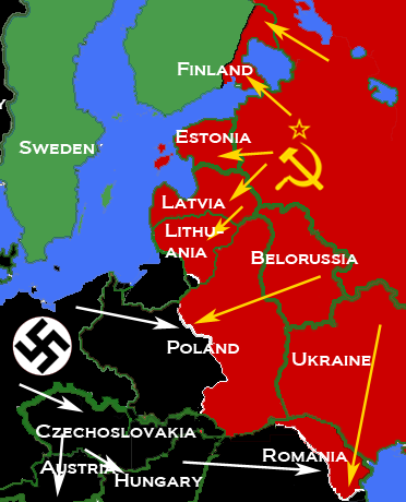
- 2009-03-09 17:05 Mosedschurte 372×460× (79594 bytes) ===English=== * Description: Second world war map on June 1941 * Source: Own map, based on the maps of the [http://www.lib.utexas.edu/maps/ University of Texas Libraries] * Author: [[User:Mosedschurte|Mosedschurte]], February 12, 2009 ===License=== {{GFD
- 2009-02-18 18:26 Mosedschurte 385×479× (64782 bytes) ===English=== * Description: Second world war map on June 1941 * Source: Own map, based on the maps of the [http://www.lib.utexas.edu/maps/ University of Texas Libraries] * Author: [[User:Mosedschurte|Mosedschurte]], February 12, 2009 ===License=== {{GFD
- 2009-02-18 07:13 Mosedschurte 377×447× (62398 bytes) ===English=== * Description: Second world war map on June 1941 * Source: Own map, based on the maps of the [http://www.lib.utexas.edu/maps/ University of Texas Libraries] * Author: [[User:Mosedschurte|Mosedschurte]], February 12, 2009 ===License=== {{GFD
- 2009-02-12 12:54 Mosedschurte 398×468× (64310 bytes) ===English=== * Description: Second world war map on June 1941 * Source: Own map, based on the maps of the [http://www.lib.utexas.edu/maps/ University of Texas Libraries] * Author: [[User:Mosedschurte|Mosedschurte]], February 12, 2009 ===License=== {{GFD
- 2009-02-12 12:50 Mosedschurte 383×463× (63199 bytes) ===English=== * Description: Second world war map on June 1941 * Source: Own map, based on the maps of the [http://www.lib.utexas.edu/maps/ University of Texas Libraries] * Author: [[User:Mosedschurte|Mosedschurte]], February 12, 2009 ===License=== {{GFD
تاريخ الملف
اضغط على زمن/تاريخ لرؤية الملف كما بدا في هذا الزمن.
| زمن/تاريخ | صورة مصغرة | الأبعاد | مستخدم | تعليق | |
|---|---|---|---|---|---|
| حالي | 09:26، 5 أبريل 2010 | | 372 × 460 (78 كيلوبايت) | Trần Nguyễn Minh Huy | {{Information |Description={{en|* Description: Map depicting most of Central and Eastern Europe, showing 1938 borders, along with Axis (black) and Soviet (red) military and political advances until late 1940. * Source: Own map, based on the maps of the [h |
استخدام الملف
الصفحة التالية تستخدم هذا الملف:
الاستخدام العالمي للملف
الويكيات الأخرى التالية تستخدم هذا الملف:
- الاستخدام في bn.wikipedia.org
- الاستخدام في bs.wikipedia.org
- الاستخدام في de.wikipedia.org
- الاستخدام في el.wikipedia.org
- الاستخدام في en.wikipedia.org
- الاستخدام في es.wikipedia.org
- الاستخدام في fr.wikipedia.org
- الاستخدام في hr.wikipedia.org
- الاستخدام في id.wikipedia.org
- الاستخدام في lv.wikipedia.org
- الاستخدام في pl.wikipedia.org
- الاستخدام في pt.wikipedia.org
- الاستخدام في ro.wikipedia.org
- الاستخدام في sr.wikipedia.org
- الاستخدام في tl.wikipedia.org
- الاستخدام في uk.wikipedia.org
- الاستخدام في vi.wikipedia.org
- الاستخدام في www.wikidata.org
- الاستخدام في zh.wikipedia.org