
ملف:Northwest Territorial Imperative map.svg

حجم معاينة PNG لذلك الملف ذي الامتداد SVG: 800 × 495 بكسل. الأبعاد الأخرى: 320 × 198 بكسل | 640 × 396 بكسل | 1٬024 × 633 بكسل | 1٬280 × 791 بكسل | 2٬560 × 1٬583 بكسل | 959 × 593 بكسل.
الملف الأصلي (ملف SVG، أبعاده 959 × 593 بكسل، حجم الملف: 92 كيلوبايت)
| هذا ملف من ويكيميديا كومنز. معلومات من صفحة وصفه مبينة في الأسفل. كومنز مستودع ملفات ميديا ذو رخصة حرة. |
| الوصف |
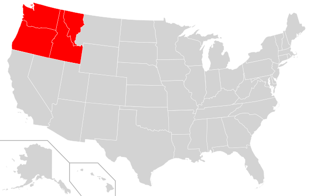
English: A map indicating the proposed home of the Northwest Territorial Imperative.
|
||
| التاريخ | (UTC) | ||
| المصدر | |||
| المؤلف |
|
||
| الترخيص (إعادة استخدام هذا الملف) |
هذا الملفُّ مُرخَّص بموجب رخصة المشاع الإبداعي [المُصنَّف إِلى مُؤَلِّفه - المشاركة بالمثل 3.0 العامة]
|
||
| SVG development | W3C-validity not checked. .هذا الرسم المتجهي أُنشئ بواسطة Inkscape |
سجلُّ الرَّفع الأصيل
This image is a derivative work of the following images:
- File:Blank_US_Map.svg licensed with Cc-by-sa-3.0-migrated, GFDL
- 2009-11-05T19:44:02Z NuclearVacuum 959x593 (91518 Bytes) minor fix from previous upload
- 2009-11-05T19:39:42Z NuclearVacuum 959x593 (88399 Bytes) Fixed up the borders so they are connected with each state and loosing that gap between them.
- 2008-10-09T16:36:40Z Howcheng 959x593 (80121 Bytes) Reverted to version as of 08:32, 14 June 2007
- 2008-03-12T00:20:02Z AMK1211 959x593 (174744 Bytes) Added borders: Light blue for water borders and black for land borders (international borders thicker).
- 2007-06-14T08:32:47Z Fibonacci 959x593 (80121 Bytes) Optimised code.
- 2006-07-12T23:00:30Z Theshibboleth 959x593 (90537 Bytes) The line framework around Alaska and Hawaii has been pushed a bit
- 2006-07-12T06:35:19Z Theshibboleth 959x593 (89828 Bytes) added DC
- 2006-07-12T06:05:05Z Theshibboleth 959x593 (89649 Bytes) {{Information |Description=A blank map of the United States in scalable vector form. |Source=Own work, based on [[:Image:Electorial map.svg]], inspired by [[:Image:BlankMap-World.png]] |Date=11 July 2006 |Author=[[User:Theshi
Uploaded with derivativeFX
تاريخ الملف
اضغط على زمن/تاريخ لرؤية الملف كما بدا في هذا الزمن.
| زمن/تاريخ | صورة مصغرة | الأبعاد | مستخدم | تعليق | |
|---|---|---|---|---|---|
| حالي | 16:18، 22 أكتوبر 2023 | | 959 × 593 (92 كيلوبايت) | Learnbeforeseptember | The proposed territory does not include Montana east of I-15 or Wyoming. |
| 17:05، 6 يناير 2011 |  | 959 × 593 (90 كيلوبايت) | Admrboltz | {{Information |Description={{en|A map indicating the proposed home of the w:Northwest Territorial Imperative.}}{{RetouchedPicture|Colored in the states of Oregon, Washington, Idaho, Montana and Wyoming|editor=Admrboltz|orig=Blank_US_Map.svg}}{{Create |
استخدام الملف
لا توجد صفحات تستخدم هذا الملف.
الاستخدام العالمي للملف
الويكيات الأخرى التالية تستخدم هذا الملف:
- الاستخدام في en.wikipedia.org
- الاستخدام في es.wikipedia.org
- الاستخدام في fa.wikipedia.org
- الاستخدام في hy.wikipedia.org
- الاستخدام في ro.wikipedia.org
- الاستخدام في ru.wikipedia.org
- الاستخدام في vi.wikipedia.org
- الاستخدام في www.wikidata.org