
ملف:1822 Geographical, Statistical, and Historical Map of Florida by Henry Charles Carey, Isaac Lea and Fielding Lucas.png

حجم هذه المعاينة: 498 × 599 بكسل. الأبعاد الأخرى: 199 × 240 بكسل | 399 × 480 بكسل | 804 × 967 بكسل.
الملف الأصلي (804 × 967 بكسل حجم الملف: 1٫39 ميجابايت، نوع MIME: image/png)
| هذا ملف من ويكيميديا كومنز. معلومات من صفحة وصفه مبينة في الأسفل. كومنز مستودع ملفات ميديا ذو رخصة حرة. |
ملخص
| الوصف |
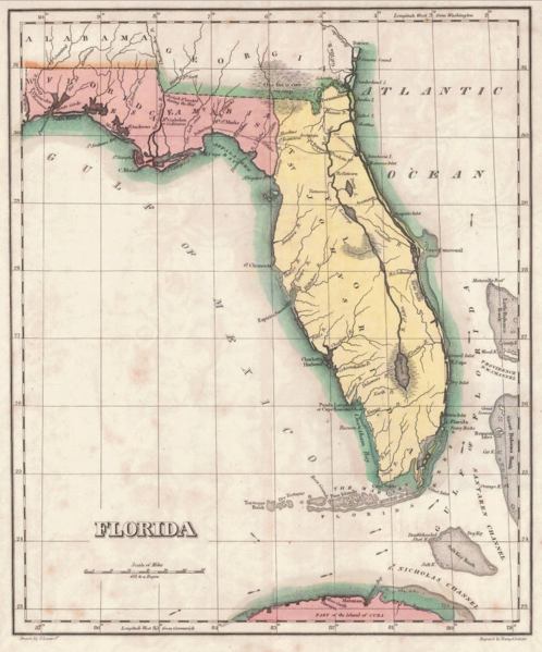
English: 1822 map of Florida Territory, published less then a year after Florida was ceded to the U.S. by Spain. The map delineates the territory's two original counties – Escambia and St. Johns, whose initial boundaries were conterminous with those of the earlier districts of East and West Florida. The interior river system is still largely anecdote and conjecture. Two roads lead west out of St. Augustine, one to Rollstown on the St. Johns River and the other to Ivitachua. A number of early northern forts are listed, including Ft. Barancas, Ft. Gadsden or Collinton, Ft. St. Marks, Ft. Poppa, Picolota Ft., and a British Fort erected during the war on the Apalachicola River. |
| التاريخ | |
| المصدر |
Original publication: A Complete Historical, Chronological, And Geographical American Atlas, Being A Guide To The History Of North And South America, And The West Indies ... To The Year 1822. According To The Plan Of Le Sage's Atlas And Intended As A Companion To Lavoisne's Improvement Of That Celebrated Work." (Philadelphia, PA: Carey and Lea, 1822) |
| المؤلف |
Henry Charles Carey, Isaac Lea, Fielding Lucas |
- Other information
English: This is an image of an original map that is in the public domain. This image is not a derivative work of the original map, as it has not been improved through techniques such as cutting out backgrounds, fixing broken lines, simplification, sharpening or otherwise cleaning up.
ترخيص
يقع هذ العمل في النَّطاق العامِّ في الولايات المُتحدة الأمريكيَّة لأنَّه نُشِرَ (أو سُجِّل لدى مكتب الولايات المُتحدة لحقوق التَّأليف والنَّشر) قبل ١ يناير ١٩٢٩.
يجب أن تكون أعمال الملكية العامة من حق المؤلفي في كل من الولايات المتحدة وفي بلد المصدر للعمل من أجل أن تكون مستضافة على موقع كومنز. إذا كان العمل ليس عمل الولايات المتحدة، يجب أن يكون لدى هذا الملف بطاقة حقوق التأليف والنشر إضافية مما يدل على حالة حقوق التأليف والنشر في بلد المصدر.
|
تاريخ الملف
اضغط على زمن/تاريخ لرؤية الملف كما بدا في هذا الزمن.
| زمن/تاريخ | صورة مصغرة | الأبعاد | مستخدم | تعليق | |
|---|---|---|---|---|---|
| حالي | 13:16، 30 يناير 2016 | | 804 × 967 (1٫39 ميجابايت) | Jeff in CA | re-cropped image |
| 10:40، 30 يناير 2016 |  | 830 × 984 (1٫82 ميجابايت) | Jeff in CA | {{subst:Upload marker added by en.wp UW}} {{Information |Description = {{en|One of the earliest obtainable separate maps of Florida following its admission as a Territory in July 1821, the map pre-dates all but St. John's County, with the only delineat... |
استخدام الملف
الصفحة التالية تستخدم هذا الملف:
الاستخدام العالمي للملف
الويكيات الأخرى التالية تستخدم هذا الملف:
- الاستخدام في bn.wikipedia.org
- الاستخدام في br.wikipedia.org
- الاستخدام في en.wikipedia.org
- الاستخدام في es.wikipedia.org
- الاستخدام في et.wikipedia.org
- الاستخدام في gl.wikipedia.org
- الاستخدام في he.wikipedia.org
- الاستخدام في pt.wikipedia.org
- الاستخدام في sr.wikipedia.org
- الاستخدام في tr.wikipedia.org
- الاستخدام في vi.wikipedia.org