انتقل إلى المحتوى

ملف:Bancdarguin oli 2019362.jpg

محتويات الصفحة غير مدعومة بلغات أخرى.
من ويكيبيديا، الموسوعة الحرة

الملف الأصلي(720 × 700 بكسل حجم الملف: 372 كيلوبايت، نوع MIME: image/jpeg)

ملخص

الوصف
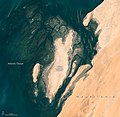
English: When viewed from space, the shoals, seagrass beds, and mudflats of Mauritania’s Banc d'Arguin National Park often blend with sand and sea in beautiful ways.

So it was on December 28, 2019, when the Operational Land Imager (OLI) on Landsat 8 captured this natural-color image of the park’s shallow coastal waters. The mostly barren dunes on the shore drew a contrast with the maze of coastal mudflats (dark brown) and shallow seagrass beds (green) that grow beneath a few meters of water. Deeper channels (dark blue) meander and flow among the sea grass and sandy shoals.

While signs of life are rare on this mostly arid land, the upwelling of cool, nutrient-rich water offshore causes the park’s coastal areas to burst with marine life. Whales, dolphins, and seals all make appearances. Thriving finfish and shellfish populations attract migratory birds to breeding sites here. Expansive tidal mudflats support upwards of 2 million shorebirds, making Banc d'Arguin one of the largest meeting places for Palaearctic birds in the world. Several endangered marine mammals occasionally turn up, notably monk seals and humpback dolphins.

But Landsat does more than deliver an occasional pretty picture. Scientists have analyzed 20 years of satellite observations and found that the park’s extensive seagrass beds have remained remarkably healthy and resilient, despite weathering occasional damage from storms and dust that temporarily killed grasses in certain areas.

NASA Earth Observatory image by Lauren Dauphin, using Landsat data from the U.S. Geological Survey. Caption by Adam Voiland.
التاريخ December 28, 2019 JPEG
المصدر https://earthobservatory.nasa.gov/images/146600/beautiful-banc-darguin-national-park?src=eoa-iotd
المؤلف NASA Earth Observatory
الترخيص
(إعادة استخدام هذا الملف)
Public domain يقع هذا العمل في النِّطاق العامّ في الولايات المُتحدة الأمريكيَّة لأَنَّه عملٌ خالِصٌ من إِنتاج وكالة الفضاء الأمريكيَّة. تنصُ حقوق التَّأليف والنَّشر الخاصَّة بوكالة الفضاء الأمريكيَّة على أنَّ "أعمال الوكالة غير مَحميَّة بحقوق التَّأليف والنَّشر ما لم يُذكر خلافُ ذلك". لمزيدٍ من المعلومات انظر القالِب {{PD-USGov}} وصفحة حقوق التَّأليف والنَّشر الخاصَّة بالوكالة وصفحة سياسة الصُّور الخاصَّة بمُختبر الدَّفع النَّفَّاث.
تنبيهات:

الشروحات

أضف شرحاً من سطر واحد لما يُمثِّله هذا الملف

العناصر المصورة في هذا الملف

يُصوِّر

4dac0ac38b14bd0844300136a718fabeb0aabd5a

طريقة الاستدلال: SHA-1 الإنجليزية

٣٨١٬١٧٥ بايت

٧٠٠ بكسل

٧٢٠ بكسل

تاريخ الملف

اضغط على زمن/تاريخ لرؤية الملف كما بدا في هذا الزمن.

زمن/تاريخصورة مصغرةالأبعادمستخدمتعليق
حالي13:53، 23 أبريل 2020تصغير للنسخة بتاريخ 13:53، 23 أبريل 2020720 × 700 (372 كيلوبايت)Tillman{{Information |description ={{en|1=When viewed from space, the shoals, seagrass beds, and mudflats of Mauritania’s Banc d'Arguin National Park often blend with sand and sea in beautiful ways. So it was on December 28, 2019, when the Operational Land Imager (OLI) on Landsat 8 captured this natural-color image of the park’s shallow coastal waters. The mostly barren dunes on the shore drew a contrast with the maze of coastal mudflats (dark brown) and shallow seagrass beds (green) that grow be...

الصفحة التالية تستخدم هذا الملف:

الاستخدام العالمي للملف

الويكيات الأخرى التالية تستخدم هذا الملف: