
ملف:Centroamerica prehispanica siglo XVI.svg

حجم معاينة PNG لذلك الملف ذي الامتداد SVG: 800 × 528 بكسل. الأبعاد الأخرى: 320 × 211 بكسل | 640 × 423 بكسل | 1٬024 × 676 بكسل | 1٬280 × 845 بكسل | 2٬560 × 1٬691 بكسل | 250٬980 × 165٬770 بكسل.
الملف الأصلي (ملف SVG، أبعاده 250٬980 × 165٬770 بكسل، حجم الملف: 499 كيلوبايت)
| هذا ملف من ويكيميديا كومنز. معلومات من صفحة وصفه مبينة في الأسفل. كومنز مستودع ملفات ميديا ذو رخصة حرة. |
| تنبيه | تحذير: يمكن لبعض مُتصفحي الإِنترنت أن يواجهوا صعوباتٍ لدى عرض هذه الصُّورة بدقَّتها الكامِلة: لدى هذه الصُّورة عدد ضخم غير اعتيادي مِن النِّقاط، ومِن المُحتمل عدم تحميلها بشكل صحيحٍ في المُتصفِّح الذي قد يتوقف عن العمل نتيجة لذلك. عوضاً عن ذلك، مِن المُستحسن أن تضغط بزرّ الفأرة اليمين على وصلة دقة كاملة وتحفظها على جهازك. عندها يمكن اسخدام برامج خارجية لعرض وتعديل الصورة.
|
|---|
ملخص
| الوصف |
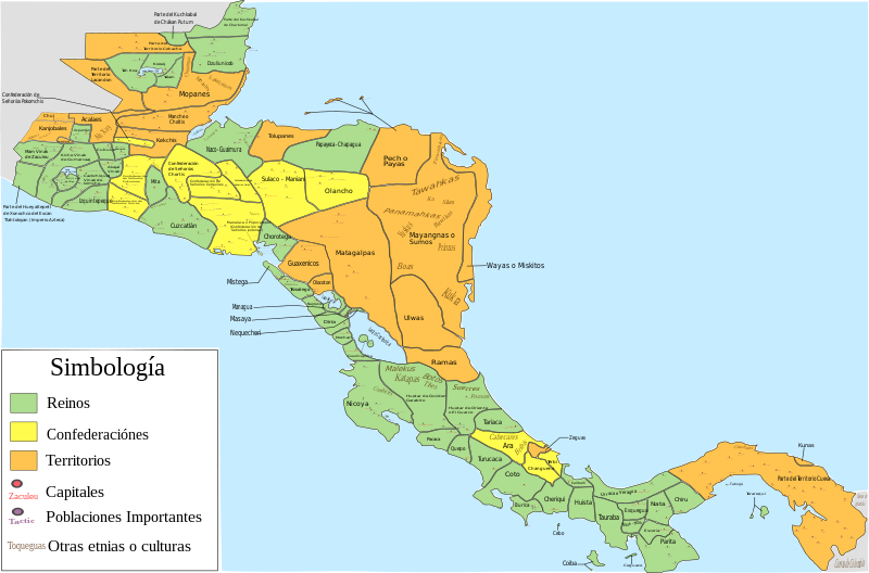
Español: Mapa de las diferentes entidades territoriales que existían en Centroamérica en el siglo XVI antes de la llegada de los españoles. En lo referente a la simbología, se tomaron en cuenta las siguientes consideraciones: Reinos, todas aquellas entidades territoriales (llamadas comúnmente señoríos o cacicazgos) que contaban con una capital y un señor principal; confederación, todas aquellas entidades conformadas por señoríos o poblaciones que aunque eran independientes tenían algún tipo de integración o alianza; territorio, todas aquellas regiones conformadas por varios señoríos o poblaciones (ya sean sedentarias, nómadas o seminómadas) que no contaban con algún tipo de integración o alianza, y de las que hay nula o escasa información de como estaban constituidos o de como se encontraban delimitados los territorios de todos o algunas entidades que se encontraban en esa región; como poblaciones importantes se toman en cuenta aquellas poblaciones que eran parte de la organización administrativa de alguna entidad, aquellas poblaciones que tuvieron un papel destacado en la conquista española de alguna entidad (como aquellas en las que se libraron batallas importantes), y las poblaciones donde se hablaban o donde aún se hablan algunas lenguas o dialectos; por último, es de mencionar que las otras etnias o culturas mostradas podrían haber estado sometidas a la entidad donde se mencionan o podrían ser independientes de dicha entidad
English: Map of the different territorial entities that existed in Central America in the XVI century before the arrive of the spanish people. With regard to symbology, the following considerations were taken: "reino" (Kingdoms), all those territorial entities (commonly called "señoríos" (lordships) or "cacicazgos") that had a capital and a principal lord; "confederación" (confederation), all those entities conformed by "señoríos" or towns that although they were independent had some type of integration or alliance; "territorio" (territory), all those regions conformed by several "señoríos" or towns (whether sedentary, nomadic or semi-nomadic) that did not count on some type of integration or alliance, and of which there is null or little information of how they were constituted or as were delimited the territories of all or someone entities that were in that region; on the other hand, as important towns are mentioned those towns that were part of the administrative organization of some entity, those towns that had a prominent role in the Spanish conquest of some entity (such as those in which important battles were fought), and the localities where some languages or dialects were spoken, or where they are still spoken today; Finally, it is worth mentioning that the other ethnic groups or cultures shown could have been submitted to the entity where they are mentioned or could be independent of said entity. |
| التاريخ | |
| المصدر |
عمل شخصي, for the elaboration of this picture were used the next resources: This file of wikimedia commons was used for great part of Costa Rica:  And, pictures or information of the nexts documents, publications or books:
|
| المؤلف | Juan Miguel |
ترخيص
أنا، صاحب حقوق التأليف والنشر لهذا العمل، أنشر هذا العمل تحت الرخصة التالية:
هذا الملفُّ مُرخَّص بموجب رخصة المشاع الإبداعي نسبة المُصنَّف إِلى مُؤَلِّفه - المشاركة بالمثل 3.0 العامة
- يحقُّ لك:
- مشاركة العمل – نسخ العمل وتوزيعه وبثُّه
- إعادة إنتاج العمل – تعديل العمل
- حسب الشروط التالية:
- نسب العمل إلى مُؤَلِّفه – يلزم نسب العمل إلى مُؤَلِّفه بشكل مناسب وتوفير رابط للرخصة وتحديد ما إذا أجريت تغييرات. بالإمكان القيام بذلك بأية طريقة معقولة، ولكن ليس بأية طريقة تشير إلى أن المرخِّص يوافقك على الاستعمال.
- الإلزام بترخيص المُشتقات بالمثل – إذا أعدت إنتاج المواد أو غيرت فيها، فيلزم أن تنشر مساهماتك المُشتقَّة عن الأصل تحت ترخيص الأصل نفسه أو تحت ترخيص مُتوافِقٍ معه.
تاريخ الملف
اضغط على زمن/تاريخ لرؤية الملف كما بدا في هذا الزمن.
| زمن/تاريخ | صورة مصغرة | الأبعاد | مستخدم | تعليق | |
|---|---|---|---|---|---|
| حالي | 06:23، 5 ديسمبر 2022 | | 250٬980 × 165٬770 (499 كيلوبايت) | Juan Miguel | Arreglando algunos detalles |
| 08:34، 5 مايو 2019 |  | 250٬976 × 165٬771 (664 كيلوبايت) | Juan Miguel | Arreglando tamaño de fuente de algunos textos | |
| 08:30، 5 مايو 2019 |  | 250٬976 × 165٬771 (663 كيلوبايت) | Juan Miguel | Arreglando tamaño de fuente de algunos textos | |
| 08:25، 5 مايو 2019 |  | 250٬976 × 165٬771 (663 كيلوبايت) | Juan Miguel | Arreglando algunos textos | |
| 06:18، 5 مايو 2019 |  | 250٬976 × 165٬771 (661 كيلوبايت) | Juan Miguel | Agregó capitales y otras poblaciones importantes, con lo cuál también se mejora los límites entre varias entidades. Además se añaden otras etnias y culturas que pueden formar parte de dicha entidad o ser independientes, y finalmente se amplía la imagen para que los diversos elementos se han más visibles | |
| 05:16، 18 ديسمبر 2018 |  | 15٬744 × 11٬093 (276 كيلوبايت) | Juan Miguel | Correcciones menores | |
| 10:52، 17 ديسمبر 2018 |  | 15٬744 × 11٬093 (277 كيلوبايت) | Juan Miguel | Pequeñas correciones | |
| 03:02، 22 أكتوبر 2018 |  | 15٬744 × 11٬093 (278 كيلوبايت) | Juan Miguel | Arreglo menor en el cuadro de simbología | |
| 02:44، 22 أكتوبر 2018 |  | 15٬744 × 11٬093 (278 كيلوبايت) | Juan Miguel | Arreglo algunas fronteras, pongo colores claros, reduzco la cantidad de colores y año el cuadro de simbología. | |
| 10:13، 16 يوليو 2017 |  | 15٬744 × 11٬093 (274 كيلوبايت) | Juan Miguel | Arreglo algunas fronteras y agrego el nombre de los lagos y el color a los océanos. |
استخدام الملف
الصفحة التالية تستخدم هذا الملف:
الاستخدام العالمي للملف
الويكيات الأخرى التالية تستخدم هذا الملف:
- الاستخدام في ast.wikipedia.org
- الاستخدام في bn.wikipedia.org
- الاستخدام في ca.wikipedia.org
- الاستخدام في en.wikipedia.org
- الاستخدام في es.wikipedia.org
- Historia de Panamá
- Historia de Honduras
- Historia de El Salvador
- Pipil
- Historia de Guatemala
- Historia de Nicaragua
- Historia de América Central
- Historia de Belice
- Señorío de Cuzcatlán
- Idioma náhuat
- Reino quiché de Q'umarkaj
- Usuario discusión:Montgomery/Archivo 15
- Chajoma
- Honduras prehispánica
- Historia precolombina de Honduras
- Historia territorial de Panamá
- Uluas
- Gran Darién
- الاستخدام في eu.wikipedia.org
- الاستخدام في fr.wikipedia.org
- الاستخدام في gl.wikipedia.org
- الاستخدام في io.wikipedia.org
- الاستخدام في ja.wikipedia.org
- الاستخدام في simple.wikipedia.org
- الاستخدام في zh.wikipedia.org