
ملف:Drumheller Channels National Natural Landmark.jpg

حجم هذه المعاينة: 800 × 461 بكسل. الأبعاد الأخرى: 320 × 184 بكسل | 640 × 369 بكسل | 1٬024 × 590 بكسل | 1٬280 × 738 بكسل | 3٬541 × 2٬041 بكسل.
الملف الأصلي (3٬541 × 2٬041 بكسل حجم الملف: 1٫09 ميجابايت، نوع MIME: image/jpeg)
| هذا ملف من ويكيميديا كومنز. معلومات من صفحة وصفه مبينة في الأسفل. كومنز مستودع ملفات ميديا ذو رخصة حرة. |
ملخص
| الوصف |
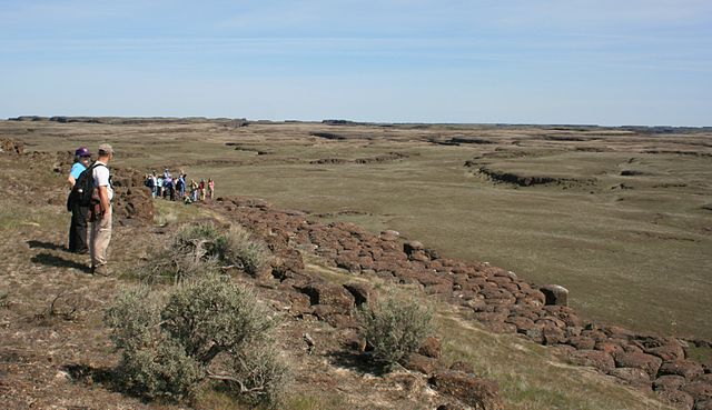
English: Drumheller Channels National Natural Landmark showcases the Drumheller Channels, which are the most significant example in the Columbia Plateau of basalt butte-and-basin channeled scablands. This National Natural Landmark is an extensively eroded landscape, located in south central Washington state characterized by hundreds of isolated, steep-sided hills (buttes) surrounded by a braided network of numerous channels, all but one of which are currently dry. It is a classic example of the tremendous erosive powers of extremely large floods such as those that reformed the Columbia Plateau volcanic terrain during the late Pleistocene glacial Missoula Floods. |
| التاريخ | التقطت في ١٨ أبريل ٢٠٠٩ |
| المصدر | عمل شخصي |
| المؤلف | Williamborg (نقاش · مساهمات) |
| الترخيص (إعادة استخدام هذا الملف) |
All rights released. |
ترخيص
| أنا، مالِك حقوق تأليف ونشر هذا العمل، أجعله في النِّطاق العامِّ، يسري هذا في أرجاء العالم كلِّه. في بعض البلدان، قد يكون هذا التَّرخيص غيرَ مُمكنٍ قانونيَّاً، في هذه الحالة: أمنح الجميع حق استخدام هذا العمل لأي غرض دون أي شرط ما لم يفرض القانون شروطًا إضافية. |
تاريخ الملف
اضغط على زمن/تاريخ لرؤية الملف كما بدا في هذا الزمن.
| زمن/تاريخ | صورة مصغرة | الأبعاد | مستخدم | تعليق | |
|---|---|---|---|---|---|
| حالي | 00:47، 19 أبريل 2009 | | 3٬541 × 2٬041 (1٫09 ميجابايت) | Williamborg | {{Information |Description={{en|1=w:Drumheller Channels National Natural Landmark showcases the '''Drumheller Channels''', which are the most significant example in the w:Columbia Plateau of basalt butte-and-basin w:channeled scablands. This [ |
استخدام الملف
الصفحة التالية تستخدم هذا الملف:
الاستخدام العالمي للملف
الويكيات الأخرى التالية تستخدم هذا الملف:
- الاستخدام في cs.wikipedia.org
- الاستخدام في de.wikipedia.org
- الاستخدام في en.wikipedia.org
- الاستخدام في www.wikidata.org