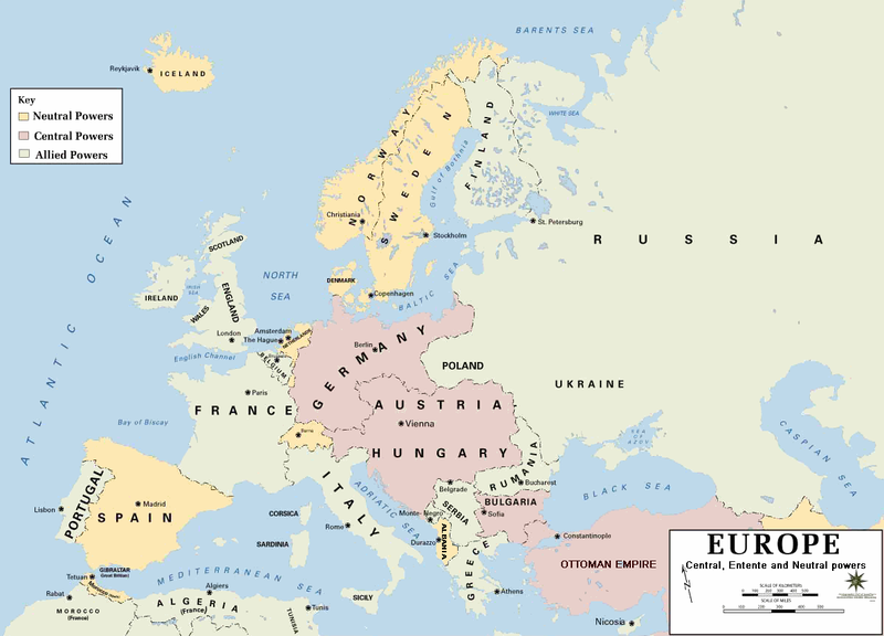
ملف:Europe 1914.png

حجم هذه المعاينة: 800 × 576 بكسل. الأبعاد الأخرى: 320 × 230 بكسل | 640 × 460 بكسل | 1٬024 × 737 بكسل | 1٬194 × 859 بكسل.
الملف الأصلي (1٬194 × 859 بكسل حجم الملف: 287 كيلوبايت، نوع MIME: image/png)
تاريخ الملف
اضغط على زمن/تاريخ لرؤية الملف كما بدا في هذا الزمن.
| زمن/تاريخ | صورة مصغرة | الأبعاد | مستخدم | تعليق | |
|---|---|---|---|---|---|
| حالي | 21:30، 18 فبراير 2011 |  | 1٬194 × 859 (287 كيلوبايت) | Ras67 | cropped and squeezed |
| 18:53، 18 فبراير 2011 |  | 1٬198 × 863 (636 كيلوبايت) | DrKay | spelling corrections | |
| 08:26، 18 فبراير 2011 |  | 1٬198 × 863 (636 كيلوبايت) | DrKay | correcting some of the errors | |
| 03:24، 4 يوليو 2010 |  | 1٬194 × 859 (236 كيلوبايت) | Ras67 | cropped | |
| 22:56، 29 يناير 2008 |  | 1٬198 × 863 (719 كيلوبايت) | Mahahahaneapneap | pngcrushed | |
| 08:23، 4 أغسطس 2006 |  | 1٬198 × 863 (726 كيلوبايت) | Wassily | *Description: '''''Europe 1914''''' *Source: [http://www.dean.usma.edu/history/web03/atlases/great%20war/great%20war%20%20pages/great%20war%20map%2002.htm www.dean.usma.edu] *Background information: ''In 1938 the predecessors of what is today The Depart |
استخدام الملف
لا توجد صفحات تستخدم هذا الملف.
الاستخدام العالمي للملف
الويكيات الأخرى التالية تستخدم هذا الملف:
- الاستخدام في af.wikipedia.org
- الاستخدام في als.wikipedia.org
- الاستخدام في bs.wikipedia.org
- الاستخدام في ckb.wikipedia.org
- الاستخدام في da.wikipedia.org
- الاستخدام في de.wikipedia.org
- الاستخدام في en.wikipedia.org
- الاستخدام في fi.wikipedia.org
- الاستخدام في fo.wikipedia.org
- الاستخدام في fr.wikipedia.org
- الاستخدام في fy.wikipedia.org
- الاستخدام في he.wikipedia.org
- الاستخدام في hu.wikipedia.org
- الاستخدام في is.wikipedia.org
- الاستخدام في it.wikipedia.org
- الاستخدام في ko.wikipedia.org
- الاستخدام في mk.wikipedia.org
- الاستخدام في nds.wikipedia.org
- الاستخدام في nl.wikipedia.org
- الاستخدام في nn.wikipedia.org
- الاستخدام في rm.wikipedia.org
- الاستخدام في simple.wikipedia.org
- الاستخدام في si.wikipedia.org
- الاستخدام في sl.wikipedia.org
- الاستخدام في sr.wikipedia.org
- الاستخدام في stq.wikipedia.org
- الاستخدام في th.wikipedia.org
- الاستخدام في uk.wikipedia.org
- الاستخدام في zh.wikipedia.org


