ملف:Europe map 1919.jpg
محتويات الصفحة غير مدعومة بلغات أخرى.
من ويكيبيديا، الموسوعة الحرة

الملف الأصلي(1٬920 × 1٬440 بكسل حجم الملف: 1٫41 ميجابايت، نوع MIME: image/jpeg)

ملخص

الوصف
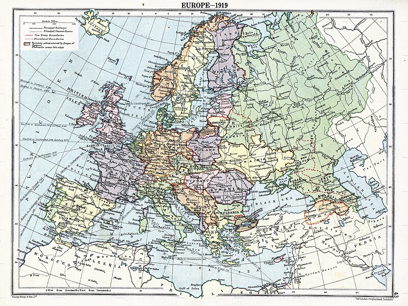
English: Map of en:Europe political divisions in 1919 (after the treaties of Brest-Litovsk and Versailles and before the treaties of Trianon, Riga, Kars and the establishment of en:Soviet Union and the republics of Ireland and Turkey) published by London Geographical Institute. This uploaded map is a photoshopped version of the original image located at hipkiss.org. According to the site, there are no copyrights to this map.
المصدر
المؤلف
إصدارات أخرى أَعمالٌ مُشتقَّة مِن هذا الملفِّ:  Europe map 1919 cropped.JPG
Maps of the history of Europe
BCE
aC

Weichselian ice age (c. 113,000–9700) · Neolithic expansion (c. 7000–4500) · Middle Neolithic (c. 4500–4000) · Late Neolithic (c. 4000–3000) · Copper Age – Corded Ware culture (c. 2900–2350) · Copper Age – Bellbeaker culture (c. 2800–1800) · Early Bronze Age – Unetice culture (c. 2300–1600) · Late Bronze Age – Urnfield culture (c. 1300—750) · Migrations (c. 1000–100) · Hallstatt & La Tène cultures (c. 800–100) · Roman Republic (510–40) · 220 · 218 · 200 · 201–100 · 58 · 49 · 39 · 30 BCE–6 CE


CE
dC

14 · 14–37 · 60 · 60 · 69 · 80 · Migrations 100–500 · 117 · 117 · 125 · Migrations 150–774 · Economy 180 · 271 · 293–305 · 337 · 395 · c. 395 · 400 · 400 · 450 · 457–61 · 476 · 480 · Franks 481–814 · Early Slavs 500–700 · 500 · 526 · 526–600 · Christianisation to 600 · c. 550 · 650 · Pontic Steppe 650 · 665 · 800 · Vikings 800–1050 · 814 · 843–70 · 850 · 900 · 912 · 998 · 1000 · 1000 · 1054 · 1092 · First Crusade 1095–99 · 1097 · 1135 · 1142 · 1147–49 · 1190 · 1190 · 1250 · c. 1250 · 1301-1400 · 1301-1400 · 1328 · 1345 · Black Plague 1347–51 · 1360 · 1400 · Trade routes c. 1400 · 1430 · 1470 · 1490 · 1492 · 1500 · 1519 · 1550 · 1560 · Religion 1560 · Religion 1600 · Religion 1618 · 1618–48 · 1648 · 1683 · 1700 · 1701 · 1708 · 1714 · 1721 · 1725–30 · 1739–1740 · 1740 · 1748–66 · 1783–1792 · 1787 · 1787 · 1789 · 1799 · 1812 · 1812 · 1812 · 1812 · 1813 · 1815 · 1815 · 1815 · 1818 · Ottoman Empire 1830–1923 · 1848–49 · 1861 · 1867 · 1871 · 1878 · 1890 · 1905 · 1911 · 1914 · 1914 · 1919 · 1919–29 · 1923 · 1929 · 1930 · 1940 · 1941–42 · 1942–45 · Cold War 1947–91 · 1950 · 1993–2006 · 2006 to date

(this template: · view · discuss )

ترخيص

Public domain
Public domain
يقع ملفُ الوسائط هذا في النِّطاق العامّ داخل الولايات المُتحدة الأمريكيَّة. وهذا ينطبق على الأعمال أمريكيَّة الأصل التي نفدت مدة حقوق تأليفها ونشرها، وهذا في الغالب الأعم عائدٌ إلى نشرها للمرة الأولى مرة قبل 1 يناير، ١٩٢٩. راجع هذه الصفحة للمزيد من التوضيح.

United States
United States
قد لا تكون هذه الصورة في النِّطاق العامّ من خارج الولايات المُتحدة، وهذا ينطبق بشكلٍ خاصٍّ في البلدان والمناطق التي لا يكون حكم الفترة الأقصر فيها نافذاً على الأعمال الأمريكية، مثل كندا وجمهورية الصين (ما خلا هونغ كونغ وماكاو) وألمانيا والمكسيك وسويسرا. إنَّ اسم المُؤَلِّف وسنة النشر هما من المعلومات الأساسيَّة، ولا بدَ من ذكرهما. انظر ويكيبيديا:الملكية العامة و‌ويكيبيديا:حقوق التأليف والنشر للمزيد من التفاصيل.

سجلُّ الرَّفع الأصيل

صفحة الوصف الأصلية كانت هنا، تشير جميع أسماء المستخدمين التالية إلى en.wikipedia.
  • 2007-11-03 20:09 MaGioZal 1996×1506×8 (1457003 bytes) Map of [[Europe]] political divisions in 1919 (after the treaties of [[Treaty_of_Brest-Litovsk|Brest-Livotsk]] and [[Treaty of Versailles|Versailles]] and before the [[Treaty of Riga]] and the creation of [[Soviet Union]]) published by London Geographical

الشروحات

أضف شرحاً من سطر واحد لما يُمثِّله هذا الملف
The situation in Europe after WW1. Several new states were born such as Ukraine(the country in Yellow at the North of the Black Sea)

العناصر المصورة في هذا الملف

يُصوِّر

تاريخ الملف

اضغط على زمن/تاريخ لرؤية الملف كما بدا في هذا الزمن.

زمن/تاريخصورة مصغرةالأبعادمستخدمتعليق
حالي05:41، 7 أغسطس 2023تصغير للنسخة بتاريخ 05:41، 7 أغسطس 20231٬920 × 1٬440 (1٫41 ميجابايت)User-duckCropped to reduce border using CropTool with lossless mode.
23:29، 22 أبريل 2008تصغير للنسخة بتاريخ 23:29، 22 أبريل 20081٬996 × 1٬506 (1٫39 ميجابايت)File Upload Bot (Magnus Manske) {{BotMoveToCommons|en.wikipedia}} {{Information |Description={{en|Map of en:Europe political divisions in 1919 (after the treaties of Brest-Livotsk and Versailles and before the treaties o

ال3 صفحات التالية تستخدم هذا الملف:

الاستخدام العالمي للملف

الويكيات الأخرى التالية تستخدم هذا الملف:

اعرض المزيد من الاستخدام العام لهذا الملف.