
ملف:IrishSeaReliefMap.jpg
حجم هذه المعاينة: 415 × 600 بكسل. الأبعاد الأخرى: 166 × 240 بكسل | 332 × 480 بكسل | 531 × 768 بكسل | 1٬043 × 1٬507 بكسل.
الملف الأصلي (1٬043 × 1٬507 بكسل حجم الملف: 2٫15 ميجابايت، نوع MIME: image/jpeg)
| هذا ملف من ويكيميديا كومنز. معلومات من صفحة وصفه مبينة في الأسفل. كومنز مستودع ملفات ميديا ذو رخصة حرة. |
ملخص
| الوصف |
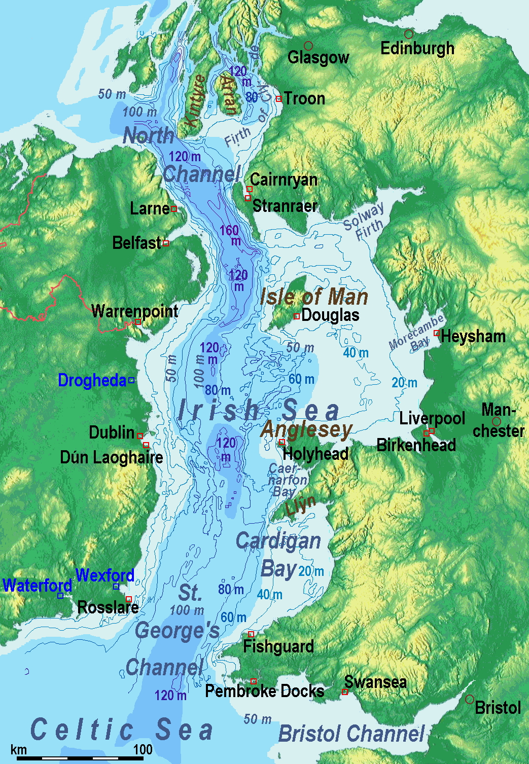
A map of the en:Irish Sea. Major ports shown with red marks. freight-only ports in blue. |
| التاريخ | old map 2005-08-03; new map 2014-05-11 |
| المصدر | old map: http://www.vindaloo.uklinux.net/jjg/code/tmutils.html-> new map: Maps for Free and عمل شخصي |
| المؤلف | old one Users SFC9394, Seabhcan on en.wikipedia, new one Ulamm (talk) 01:37, 11 May 2014 (UTC) |
| الترخيص (إعادة استخدام هذا الملف) |
old map: from http://www.vindaloo.uklinux.net/jjg/code/tmutils.html. Released to public domain by creator. |
| إصدارات أخرى |
History of the od map
Old map riginally from en.wikipedia; description page is (was) here
- 14:22, 20 March 2006 SFC9394 461×561 (85,860 bytes) (Corrected locations for Cairnryan & Stranraer)
- 10:56, 25 November 2005 Seabhcan 461×561 (73,292 bytes) (Removed the ports of Heysham and Fleetwood, to which en:User:Robdurbar took offence. )
- 16:23, 3 August 2005 Seabhcan 461×561 (95,162 bytes) (Added channel names)
- 15:50, 3 August 2005 Seabhcan 461×561 (93,219 bytes) (A map of the en:Irish Sea Major ports shown in red. freight only ports in blue. from [1]. Released to public domain by creator.)
Sources of information for the new map
- internal report Nr. 174 of the National Oceanography Centre (Liverpool)
- http://www.dcenr.gov.ie (Department of Communications, Energy and Natural Resources) -> IOSEA4Annex–Master–r02–Fiinal.pdf (Fourth Strategic Environmental Assessment for Oil and Gas ACtivity in Irelands Offshore Waters) -> figures 2.1 & 2.2a
ترخيص
أنا، صاحب حقوق التأليف والنشر لهذا العمل، أنشر هذا العمل تحت الرخصة التالية:
هذا الملفُّ مُرخَّص بموجب رخصة المشاع الإبداعي نسبة المُصنَّف إِلى مُؤَلِّفه - المشاركة بالمثل 3.0 العامة
- يحقُّ لك:
- مشاركة العمل – نسخ العمل وتوزيعه وبثُّه
- إعادة إنتاج العمل – تعديل العمل
- حسب الشروط التالية:
- نسب العمل إلى مُؤَلِّفه – يلزم نسب العمل إلى مُؤَلِّفه بشكل مناسب وتوفير رابط للرخصة وتحديد ما إذا أجريت تغييرات. بالإمكان القيام بذلك بأية طريقة معقولة، ولكن ليس بأية طريقة تشير إلى أن المرخِّص يوافقك على الاستعمال.
- الإلزام بترخيص المُشتقات بالمثل – إذا أعدت إنتاج المواد أو غيرت فيها، فيلزم أن تنشر مساهماتك المُشتقَّة عن الأصل تحت ترخيص الأصل نفسه أو تحت ترخيص مُتوافِقٍ معه.
(Uploaded using CommonsHelper or PushForCommons)
تاريخ الملف
اضغط على زمن/تاريخ لرؤية الملف كما بدا في هذا الزمن.
| زمن/تاريخ | صورة مصغرة | الأبعاد | مستخدم | تعليق | |
|---|---|---|---|---|---|
| حالي | 11:42، 13 مايو 2014 | | 1٬043 × 1٬507 (2٫15 ميجابايت) | Ulamm | optimized colour scale |
| 14:17، 12 مايو 2014 |  | 1٬043 × 1٬507 (1٫87 ميجابايت) | Ulamm | more names, smaller letters | |
| 12:25، 11 مايو 2014 |  | 1٬043 × 1٬449 (1٫73 ميجابايت) | Ulamm | depths and names of bays and inlets | |
| 10:56، 11 مايو 2014 |  | 1٬043 × 1٬449 (1٫71 ميجابايت) | Ulamm | land colours lightened | |
| 02:22، 11 مايو 2014 |  | 1٬043 × 1٬449 (1٫7 ميجابايت) | Ulamm | more ports | |
| 01:50، 11 مايو 2014 |  | 1٬043 × 1٬449 (1٫69 ميجابايت) | Ulamm | completion outside the Irish Sea | |
| 01:39، 11 مايو 2014 |  | 1٬043 × 1٬449 (1٫68 ميجابايت) | Ulamm | completely new map | |
| 09:01، 1 نوفمبر 2006 |  | 461 × 561 (84 كيلوبايت) | Korrigan | {{Information| |Description= A map of the en:Irish Sea Major ports shown in red. freight only ports in blue. |Source= |Date= |Author=Users SFC9394, Seabhcan on [http://en.wikipedia.org en.wikipedia] |Permiss |
استخدام الملف
لا توجد صفحات تستخدم هذا الملف.
الاستخدام العالمي للملف
الويكيات الأخرى التالية تستخدم هذا الملف:
- الاستخدام في af.wikipedia.org
- الاستخدام في an.wikipedia.org
- الاستخدام في ast.wikipedia.org
- الاستخدام في ba.wikipedia.org
- الاستخدام في be.wikipedia.org
- الاستخدام في bg.wikipedia.org
- الاستخدام في bn.wikipedia.org
- الاستخدام في br.wikipedia.org
- الاستخدام في ca.wikipedia.org
- الاستخدام في cs.wikipedia.org
- الاستخدام في cv.wikipedia.org
- الاستخدام في cy.wikipedia.org
- الاستخدام في da.wikipedia.org
- الاستخدام في el.wikipedia.org
- الاستخدام في eo.wikipedia.org
- الاستخدام في es.wikipedia.org
- الاستخدام في eu.wikipedia.org
- الاستخدام في fa.wikipedia.org
- الاستخدام في fy.wikipedia.org
- الاستخدام في gl.wikipedia.org
- الاستخدام في gv.wikipedia.org
- الاستخدام في he.wikipedia.org
- الاستخدام في hu.wikipedia.org
- الاستخدام في hu.wiktionary.org
- الاستخدام في id.wikipedia.org
- الاستخدام في is.wikipedia.org
- الاستخدام في ka.wikipedia.org
- الاستخدام في kk.wikipedia.org
- الاستخدام في ko.wikipedia.org
- الاستخدام في ku.wikipedia.org
- الاستخدام في lmo.wikipedia.org
اعرض المزيد من الاستخدام العام لهذا الملف.