
ملف:London, Greenwich, Royal Greenwich Observatory -- 2016 -- 4745-6-8.jpg

حجم هذه المعاينة: 424 × 599 بكسل. الأبعاد الأخرى: 170 × 240 بكسل | 340 × 480 بكسل | 544 × 768 بكسل | 725 × 1٬024 بكسل | 1٬450 × 2٬048 بكسل | 5٬154 × 7٬277 بكسل.
الملف الأصلي (5٬154 × 7٬277 بكسل حجم الملف: 25٫62 ميجابايت، نوع MIME: image/jpeg)
| هذا ملف من ويكيميديا كومنز. معلومات من صفحة وصفه مبينة في الأسفل. كومنز مستودع ملفات ميديا ذو رخصة حرة. |
ملخص
| الوصف |
Deutsch: Shepherd gate clock am Royal Greenwich Observatory, London, England, Vereinigtes Königreich
Русский: Лондон, Гринвич, Королевская Гринвичская обсерватория
Тоҷикӣ: Лондон, Гринвич, Расадхонаи Роял Гринвич
|
||||||||||||||||||||||||||||||||
| الموقع | |||||||||||||||||||||||||||||||||
| يُصوِّر | المرصد الملكي – observatory in Greenwich, London, UK | ||||||||||||||||||||||||||||||||
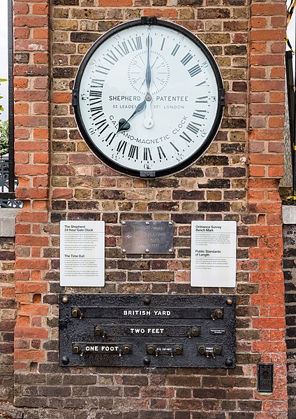
| الوصوفات | ساعة (الأعلى): SHEPHERD PATENTEE // 53 LEADENHALL ST(T) LONDON // GALVANO-MAGNETIC CLOCK
لافتة تاريخية (يسار): The Shepherd 24-hour Gate Clock // This is one of the earliest electrically driven public clocks and was installed here in 1852. The dial always shows Greenwich Mean Time (GMT). In summer Britain converts to British Summer Time (BST), which is an hour ahead of GMT, and the clock then appears one hour 'slow'. Being 24-hour clock, the hour hand marks noon (XII) at the bottom of the dial and midnight (0) at the top. The time shown is accurate to 0.5 of a second. // The Time Ball // The red time ball on top of Flamsteed House is one of the world's first visual time signals. It was installed in 1833 (though the present one dates to 1919) to enable navigators on ships on the Thames to check their marine chronometers. The Time Ball drops daily at 1300hrs (GMT in winter, BST in summer). It is raised halfway up the mast at 1255hrs as a preparatory signal and to the top 2 minutes before it drops. لافتة تاريخية (middle): Height above Mean Sea Level at Newlyn 154.70 feet.
لافتة تاريخية (يمين): Ordnance Survey Bench Mark // The small plate (marked 'G 1692') is an Ordnance Survey bench mark. Similar marks appear on walls and buildings across the country. The height of each above sea level has been measured and recorded. Dating from the 1940s, this particular mark is a replacement for an older mark that once existed nearby. // Public Standards of Length // These British Imperial Standards were first mounted outside the Observatory main gates some time before 1866, to enable the public to check measures of length. The stated length is the distance between the inner faces of the two D-shaped studs. محدد قياس (الأسفل): BRITISH YARD // TWO FEET // ONE FOOT // SIX INCHES // THREE INCHES // TROUGHTON & SIMMS LONDON // O S B M G 1692
|
||||||||||||||||||||||||||||||||
| معلومات تقنية |
|
||||||||||||||||||||||||||||||||
| بيانات الصورة |
|
||||||||||||||||||||||||||||||||
| التاريخ | التقطت في ٩ أكتوبر ٢٠١٦, ١٧:٠٠ | ||||||||||||||||||||||||||||||||
| المصدر | عمل شخصي | ||||||||||||||||||||||||||||||||
| المؤلف |
|
||||||||||||||||||||||||||||||||
| الترخيص (إعادة استخدام هذا الملف) |
 .svg) I. Licence
This photograph is protected by copyright law. However, it may be used for free by anyone, provided it is used in accordance with the license Creative Commons License “Attribution-ShareAlike 4.0 International” (CC BY-SA 4.0). These include, among other things, the naming of the author and the license, as well as the setting of a link to the license text or its complete imprint. The attribution should be done as follows:
Please read the text of the license carefully before using the photograph. If you do not agree with the conditions of the license or if you do not understand these conditions, please refrain from using the photo. If you have any questions regarding the license or the reuse of the image, please contact me before using it. If you do not comply with the terms of the license, you do not acquire any right to use the image. If you need another license to use, please contact the author before using.
For informations about the licence see section ترخيص or as human-readable summary or as full licence text at Creative Commons. In addition to the above, a link to the source - so this page with the descriptions and license terms - is appreciated. More information or examples of use can be found at re-use (with example file). The Attribution Generator is helpful in licensing matters.
As an alternative to the Creative Commons License CC BY-SA 4.0, the Free Art License (from version 1.3) may also be used.
II. Fairness
From printed materials and other tangible products that use that work, the user is asked to send a copy to the author as thank you. However, this is not a condition for the use of the photo, but a voluntary service. The mailing address can be requested via the contact options.
Please note that the author had quite considerable effort to draw up this file. Thus, it is only fair to comply with the conditions of free licenses listed here. In the case of violation of the license conditions, the rights granted hereunder will expire automatically.
III. Disclaimer
Please note that the license applies solely for the reuse of the photograph itself. The license doesn't grant you any right regarding the depicted object (eg, copyright or proprietary rights) or the personality rights of the person eventually shown. (See licences and non-copyright restrictions.) I do not grant any warranty that the subsequent use of the photograph is legally possible concerning the object or person shown in the photograph. You are responsible to check and respect these rights in the publication in the respective medium or country.
The author is not responsible for the accuracy of the information contained herein (description, title, etc.). Likewise, the author assumes no liability for further use. Please note the general disclaimer and please read reusing content outside Wikimedia too.
IV. Contact
|
||||||||||||||||||||||||||||||||
| نسب العمل لمُؤَلِّفه (required by the license) | Dietmar Rabich / Wikimedia Commons / /
|
||||||||||||||||||||||||||||||||
| Keywords | Architectural element, Architecture, Architektur, Architekturelement, Bauwerk, Black, Building, Denkmal, Door, England, Gate, Gebäude, Gedenktafel, Greenwich, Großbritannien, Kultur, Kulturdenkmal, Kunst, London, Mauer, Möbel, Object, Objekt, Panorama, Panoramaaufnahme, Panoramics, Qualitätsbild, Quality image, Road, Royal Greenwich Observatory, Schild, Schutzgebiet, Schwarz, Schwarzweiß, Sculpture, Sign, Skulptur, Stadtmöbel, Straße, Straßenmöbel, Straßen und Wege, Street, Tor, Tür, Uhr, UNESCO-Welterbe, United Kingdom, Vereinigtes Königreich, Verkehr, Weiß, Welterbe, White, World Heritage Site, 1852, 2016 | ||||||||||||||||||||||||||||||||


| موقع الكائن | | هذه وغيرها من الصور في مواقعها على: خريطة الشارع المفتوحة |
|---|
| موقع الكاميرا | | هذه وغيرها من الصور في مواقعها على: خريطة الشارع المفتوحة |
|---|
|
هذا المكان هو موقع تراثٍ عالميٌّ، مُصنَّفٌ ضمن
Maritime Greenwich.
|

|
ملاحظة: تقدِّم هذه الصُّورة رؤيةً شاملةً تتكون مِن عدَّة إطاراتٍ دُمِجت معاً أو وُضِعت بجانب بعضها البعض بواسطة برمجيَّات مُخصصة. نتيجةً لذلك، فإِنَّ هذه الصُّورة مرَّت بمرحلة معالجةٍ رقميَّةٍ ضروريَّةٍ، قد تشمل عمليات مَزجٍ أَو تشتيتٍ أَو نسخٍ أَو تلوينٍ أَو تعديلٍ في المَنظُور، ولهذا، فإِنَّ مُحتوَى الصُّورة قد يَكُون مُختلِفاً بعض الشَّيء عَن الأُصُول الَّتي جُمِعت مع بعضها البعض. غالباً ما تَكُون هذه المُعالَجة لازمةً لإزالة التَّشوهات النَّاجمة عن عدسات التَّصوير أو لأسبابٍ أُخرى.
|
التقييم
|
|
ترخيص
Dietmar Rabich، صاحب حقوق التأليف والنشر لهذا العمل، أنشر هذا العمل تحت الرخصة التالية:
هذا الملفُّ مُرخَّصٌ برخصة المشاع الإبداعي الدَّوليَّة المُلزِمة بنسب العمل إلى مُؤَلِّفه وبترخيص المُشتقَّات بالمثل 4.0.
نسب العمل لمُؤَلِّفه: Dietmar Rabich
- يحقُّ لك:
- مشاركة العمل – نسخ العمل وتوزيعه وبثُّه
- إعادة إنتاج العمل – تعديل العمل
- حسب الشروط التالية:
- نسب العمل إلى مُؤَلِّفه – يلزم نسب العمل إلى مُؤَلِّفه بشكل مناسب وتوفير رابط للرخصة وتحديد ما إذا أجريت تغييرات. بالإمكان القيام بذلك بأية طريقة معقولة، ولكن ليس بأية طريقة تشير إلى أن المرخِّص يوافقك على الاستعمال.
- الإلزام بترخيص المُشتقات بالمثل – إذا أعدت إنتاج المواد أو غيرت فيها، فيلزم أن تنشر مساهماتك المُشتقَّة عن الأصل تحت ترخيص الأصل نفسه أو تحت ترخيص مُتوافِقٍ معه.
ملاحظات
Photographs
|
You like this photograph? That pleases me very much! You would like to see more of my pictures? With pleasure.
Wikimedia Commons has a large number of my photographs available under a free license. This makes it easy for you and me. The license details are for each picture. The use is easier than you think, because in essence, this is just the attribution in the form I want. In addition, usage notes are listed for each picture. And if it does not fit, just ask. My contact information is also available with every photograph. |
,_Harbour_--_2013_--_1494.jpg)


تاريخ الملف
اضغط على زمن/تاريخ لرؤية الملف كما بدا في هذا الزمن.
| زمن/تاريخ | صورة مصغرة | الأبعاد | مستخدم | تعليق | |
|---|---|---|---|---|---|
| حالي | 06:56، 1 نوفمبر 2016 | | 5٬154 × 7٬277 (25٫62 ميجابايت) | XRay | VicuñaUploader 1.23 |
استخدام الملف
الصفحة التالية تستخدم هذا الملف:
الاستخدام العالمي للملف
الويكيات الأخرى التالية تستخدم هذا الملف:
- الاستخدام في arz.wikipedia.org
- الاستخدام في ja.wikipedia.org
- الاستخدام في ru.wikinews.org
- الاستخدام في tg.wikipedia.org
- الاستخدام في udm.wikipedia.org
- الاستخدام في www.wikidata.org