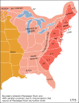
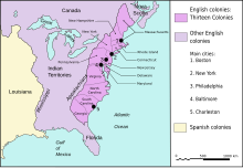
ملف:Map of territorial growth 1775.jpg

حجم هذه المعاينة: 456 × 600 بكسل. البعدان الآخران: 182 × 240 بكسل | 570 × 750 بكسل.
الملف الأصلي (570 × 750 بكسل حجم الملف: 172 كيلوبايت، نوع MIME: image/jpeg)
تاريخ الملف
اضغط على زمن/تاريخ لرؤية الملف كما بدا في هذا الزمن.
| زمن/تاريخ | صورة مصغرة | الأبعاد | مستخدم | تعليق | |
|---|---|---|---|---|---|
| حالي | 03:07، 30 مارس 2013 |  | 570 × 750 (172 كيلوبايت) | Ras67 | cropped |
| 04:44، 3 ديسمبر 2006 |  | 620 × 800 (122 كيلوبايت) | Dedee73 | The first 13 american colonies | |
| 21:13، 6 يونيو 2005 |  | 620 × 800 (122 كيلوبايت) | Kooma | Map of territorial growth, 1775. From en.wiki. {{PD-USGov-Atlas}} Category:American Revolution |
استخدام الملف
الصفحة التالية تستخدم هذا الملف:
الاستخدام العالمي للملف
الويكيات الأخرى التالية تستخدم هذا الملف:
- الاستخدام في az.wikipedia.org
- الاستخدام في bg.wikipedia.org
- الاستخدام في bn.wikipedia.org
- الاستخدام في ca.wikipedia.org
- الاستخدام في da.wikipedia.org
- الاستخدام في el.wikipedia.org
- الاستخدام في en.wikipedia.org
- American cuisine
- Empire
- British North America
- History of the United States (1776–1789)
- Timeline of the American Revolution
- Public Land Survey System
- History of Pennsylvania
- Constitutional history of Canada
- Cultural assimilation of Native Americans
- User:Notuncurious/Working/tmp3
- User:Notuncurious/Working/tmp6
- Aboriginal title in the United States
- Aboriginal title statutes in the Thirteen Colonies
- User:Purplebackpack89/SimpleWikipediaHoftheUS
- Talk:United States Declaration of Independence/Archive 8
- George Washington's political evolution
- User:Lodzdeena/ABŞ tarixi (1776–1789)
- User:Lodzdeena/test
- User:Falcaorib/Canada, United States and Mexico
- الاستخدام في en.wikibooks.org
- الاستخدام في en.wikiversity.org
- الاستخدام في fa.wikipedia.org
- الاستخدام في fr.wikipedia.org
- الاستخدام في fr.wikisource.org
- الاستخدام في gl.wikipedia.org
- الاستخدام في he.wikipedia.org
- الاستخدام في hu.wikipedia.org
اعرض المزيد من الاستخدام العام لهذا الملف.


