
ملف:New-Map-Francophone World.PNG

حجم هذه المعاينة: 800 × 441 بكسل. الأبعاد الأخرى: 320 × 176 بكسل | 640 × 353 بكسل | 1٬024 × 564 بكسل | 1٬280 × 705 بكسل | 2٬664 × 1٬468 بكسل.
الملف الأصلي (2٬664 × 1٬468 بكسل حجم الملف: 93 كيلوبايت، نوع MIME: image/png)
| هذا ملف من ويكيميديا كومنز. معلومات من صفحة وصفه مبينة في الأسفل. كومنز مستودع ملفات ميديا ذو رخصة حرة. |
ملخص
| الوصف |
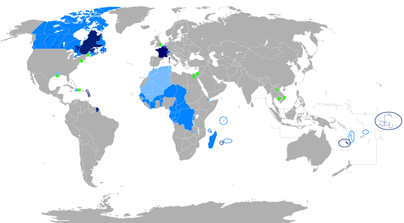
English: The French language and French creoles in the world
Regions where French or a French creole is the main language
Regions where it is an official language
Regions where it is a second language
Regions where it is a minority language
The following things have been changed from the old "Map-Francophone World.PNG":
To be modified :
Français : La langue française dans le monde
Langue maternelle
Langue officielle
Deuxième langue
Minorités francophones
Les choses suivantes ont été modifiées de l'ancien "Map-Frncophone World.PNG":
Proposition de modification : L'usage de la langue française est divers dans les pays d'Afrique subsaharienne. Par exemple, le français n'est pas la langue utilisée par défaut dans les rues sénégalaises. Tout au contraire, prétendre que le français n'est pas la langue maternelle des Gabonais reviendrait à dire que le français n'était rien de plus qu'une langue officielle dans la Bretagne des années cinquante. Ne connaissant pas la situation des autres pays, je laisse le soin à toute personne motivée de corriger cette erreur.
Català: La llengua francesa al món
Llengua materna
Llengua oficial
Segona Llengua
Minories francòfones |
| التاريخ | |
| المصدر | عمل شخصي |
| المؤلف | aaker |

|
يُمثِّل: File:New-Map-Francophone World.svg نسخةً شعاعيَّةً لهذه الصورة. ينبغي أن تستخدم الصورة الشعاعيَّة عندما تكون أعلى جودةً مِن الصورة النقطيَّة.
File:New-Map-Francophone World.PNG → File:New-Map-Francophone World.svg
للمزيد من المعلومات، راجع صفحة Help:SVG. |
 |
ترخيص
| أنا، مالِك حقوق تأليف ونشر هذا العمل، أجعله في النِّطاق العامِّ، يسري هذا في أرجاء العالم كلِّه. في بعض البلدان، قد يكون هذا التَّرخيص غيرَ مُمكنٍ قانونيَّاً، في هذه الحالة: أمنح الجميع حق استخدام هذا العمل لأي غرض دون أي شرط ما لم يفرض القانون شروطًا إضافية. |
تاريخ الملف
اضغط على زمن/تاريخ لرؤية الملف كما بدا في هذا الزمن.
| زمن/تاريخ | صورة مصغرة | الأبعاد | مستخدم | تعليق | |
|---|---|---|---|---|---|
| حالي | 00:15، 30 يوليو 2023 | | 2٬664 × 1٬468 (93 كيلوبايت) | Riad Salih | Western Sahara is an old Spanish colony, and French is not commonly used there. |
| 00:10، 30 يوليو 2023 |  | 2٬664 × 1٬468 (93 كيلوبايت) | Riad Salih | Since July 2023, French is no longer an official language in Mali, but a language of work. | |
| 06:49، 30 أبريل 2023 |  | 2٬664 × 1٬468 (205 كيلوبايت) | Moalli | Remove green square in middle of Mediterranean, no country located there | |
| 22:50، 15 مارس 2023 |  | 2٬664 × 1٬468 (105 كيلوبايت) | Kwamikagami | update some per WP-en article, though this map not used much anymore | |
| 10:21، 9 أغسطس 2019 |  | 2٬664 × 1٬468 (120 كيلوبايت) | Benderban01 | Reverted to version as of 15:28, 17 July 2018 (UTC) | |
| 09:07، 6 أغسطس 2019 |  | 2٬664 × 1٬468 (119 كيلوبايت) | Benderban01 | Removed the small thing on ontario. | |
| 09:01، 6 أغسطس 2019 |  | 2٬664 × 1٬468 (119 كيلوبايت) | Benderban01 | Removed 8 provinces where french is not the official language, there 3 territorries which will spoke minority. | |
| 15:28، 17 يوليو 2018 |  | 2٬664 × 1٬468 (120 كيلوبايت) | Maphobbyist | Reverted to version as of 18:46, 4 January 2018 (UTC) | |
| 09:53، 27 يونيو 2018 |  | 2٬664 × 1٬468 (100 كيلوبايت) | Motiss | ||
| 09:50، 27 يونيو 2018 |  | 2٬664 × 1٬468 (120 كيلوبايت) | Motiss | Reverted to version as of 18:46, 4 January 2018 (UTC) |
استخدام الملف
لا توجد صفحات تستخدم هذا الملف.
الاستخدام العالمي للملف
الويكيات الأخرى التالية تستخدم هذا الملف:
- الاستخدام في de.wikipedia.org
- الاستخدام في en.wikipedia.org
- Category:Wikipedians in Luxembourg
- Category:Wikipedians in Switzerland
- Category:WikiProject Luxembourg participants
- Category:WikiProject Switzerland participants
- Category:Swiss Wikipedians
- Talk:English language/Archive 18
- Talk:French language/Archive 3
- Category:Wikipedians interested in Luxembourg
- Category:Wikipedians interested in Switzerland
- Category:Luxembourg Wikipedians
- Template:Portal/doc/all
- Wikipedia:Reference desk/Archives/Humanities/2013 October 5
- User:Matt Fitzpatrick/portal images
- Wikipedia:Userboxes/Location/Luxembourg
- Wikipedia:Userboxes/Location/Switzerland
- Template:User Luxembourg/cat
- Template:User Switzerland/cat
- Template:User Luxembourg/boxes
- Template:User Switzerland/boxes
- الاستخدام في es.wikipedia.org
- الاستخدام في fi.wikipedia.org
- الاستخدام في fr.wikipedia.org
- Discussion:Francophonie
- Discussion utilisateur:Le sotré
- Liste des pays ayant le français pour langue officielle
- Wikipédia:Le Bistro/24 février 2008
- Utilisateur:Brochon99/Bac à sable 5/Documentation
- Wikipédia:Le Bistro/18 décembre 2009
- Utilisateur:Kimdime/stats
- Utilisateur:Ygdrasil/http://Liste langue par nbr locuteur
- Utilisateur:Televido/Récolte
- Wikipédia:Le Bistro/25 juillet 2017
- Wikipédia:Le Bistro/30 juillet 2017
- الاستخدام في fr.wikinews.org
- الاستخدام في fr.wiktionary.org
- الاستخدام في jv.wikipedia.org
- الاستخدام في km.wikipedia.org
- الاستخدام في nl.wikipedia.org
- الاستخدام في so.wikipedia.org
- الاستخدام في tum.wikipedia.org