
ملف:PIA19805-SeasonalFlows-CopratesChasma-VallesMarineris-20150721.jpg

الملف الأصلي (975 × 1٬023 بكسل حجم الملف: 107 كيلوبايت، نوع MIME: image/jpeg)
| هذا ملف من ويكيميديا كومنز. معلومات من صفحة وصفه مبينة في الأسفل. كومنز مستودع ملفات ميديا ذو رخصة حرة. |
ملخص
| الوصف |
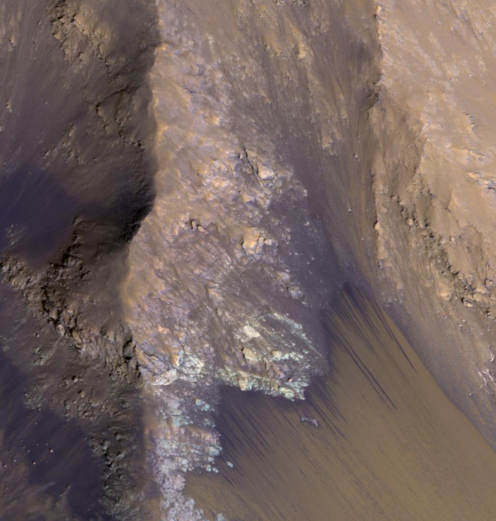
English: PIA19805: For Anniversary of Orbiter's Launch: Seasonal Flows in Mars' Valles Marineris
http://photojournal.jpl.nasa.gov/catalog/PIA19805 Among the many discoveries by NASA's Mars Reconnaissance Orbiter since the mission was launched on Aug. 12, 2005, are seasonal flows on some steep slopes. These flows have a set of characteristics consistent with shallow seeps of salty water. This July 21, 2015, image from the orbiter's High Resolution Imaging Science Experiment (HiRISE) camera shows examples of these flows on a slope within Coprates Chasma, which is part of the grandest canyon system on Mars, Valles Marineris. The image covers an area of ground one-third of a mile (536 meters) wide. These flows are called recurring slope lineae because they fade and disappear during cold seasons and reappear in warm seasons, repeating this pattern every Martian year. The flows seen in this image are on a north-facing slope, so they are active in northern-hemisphere spring. The flows emanate from the relatively bright bedrock and flow onto sandy fans, where they are remarkably straight, following linear channels. Valles Marineris contains more of these flows than everywhere else on Mars combined. At any season, some are active, though on different slope aspects at different seasons. Future human explorers (and settlers?) will need water to drink, grow food, produce oxygen to breath, and make rocket fuel. Bringing all of that water from Earth would be extremely expensive, so using water on Mars is essential. Although there is plenty of water ice at high latitudes, surviving the cold winters would be difficult. An equatorial source of water would be preferable, so Valles Marineris may be the best destination. However, the chemistry of this water must be understood before betting any lives on it. For more information about recurring slope lineae, see http://www.jpl.nasa.gov/news/news.php?feature=3981 and http://www.uahirise.org/sim/2013-12-10/. The location of the site in this image is 12.9 degrees south latitude, 295.4 degrees east latitude. The image is an excerpt from HiRISE observation ESP_042228_1670. Other image products from this observation are available at http://hirise.lpl.arizona.edu/ESP_042228_1670. HiRISE is one of six instruments on the Mars Reconnaissance Orbiter. The University of Arizona, Tucson, operates HiRISE, which was built by Ball Aerospace & Technologies Corp., Boulder, Colorado. NASA's Jet Propulsion Laboratory, a division of the California Institute of Technology in Pasadena, manages the Mars Reconnaissance Orbiter Project for NASA's Science Mission Directorate, Washington. Lockheed Martin Space Systems, Denver, built the orbiter and collaborates with JPL to operate it. |
| التاريخ | |
| المصدر | http://photojournal.jpl.nasa.gov/jpeg/PIA19805.jpg |
| المؤلف | NASA/JPL-Caltech/Univ. of Arizona |
ترخيص
| يقع هذا العمل في النِّطاق العامّ في الولايات المُتحدة الأمريكيَّة لأَنَّه عملٌ خالِصٌ من إِنتاج وكالة الفضاء الأمريكيَّة. تنصُ حقوق التَّأليف والنَّشر الخاصَّة بوكالة الفضاء الأمريكيَّة على أنَّ "أعمال الوكالة غير مَحميَّة بحقوق التَّأليف والنَّشر ما لم يُذكر خلافُ ذلك". لمزيدٍ من المعلومات انظر القالِب {{PD-USGov}} وصفحة حقوق التَّأليف والنَّشر الخاصَّة بالوكالة وصفحة سياسة الصُّور الخاصَّة بمُختبر الدَّفع النَّفَّاث. | ||
 |
تنبيهات:
|
تاريخ الملف
اضغط على زمن/تاريخ لرؤية الملف كما بدا في هذا الزمن.
| زمن/تاريخ | صورة مصغرة | الأبعاد | مستخدم | تعليق | |
|---|---|---|---|---|---|
| حالي | 12:15، 11 أغسطس 2015 | | 975 × 1٬023 (107 كيلوبايت) | Drbogdan | User created page with UploadWizard |
استخدام الملف
الصفحة التالية تستخدم هذا الملف:
الاستخدام العالمي للملف
الويكيات الأخرى التالية تستخدم هذا الملف:
- الاستخدام في en.wikipedia.org
- الاستخدام في fr.wikipedia.org
- الاستخدام في it.wikipedia.org
- الاستخدام في uk.wikipedia.org
- الاستخدام في www.wikidata.org
- الاستخدام في zh.wikipedia.org