
ملف:Sandy 2012-10-29 1815Z.jpg

الملف الأصلي (11٬202 × 18٬000 بكسل حجم الملف: 67٫73 ميجابايت، نوع MIME: image/jpeg)
| هذا ملف من ويكيميديا كومنز. معلومات من صفحة وصفه مبينة في الأسفل. كومنز مستودع ملفات ميديا ذو رخصة حرة. |
| تنبيه | تحذير: يمكن لبعض مُتصفحي الإِنترنت أن يواجهوا صعوباتٍ لدى عرض هذه الصُّورة بدقَّتها الكامِلة: لدى هذه الصُّورة عدد ضخم غير اعتيادي مِن النِّقاط، ومِن المُحتمل عدم تحميلها بشكل صحيحٍ في المُتصفِّح الذي قد يتوقف عن العمل نتيجة لذلك. عوضاً عن ذلك، مِن المُستحسن أن تضغط بزرّ الفأرة اليمين على وصلة دقة كاملة وتحفظها على جهازك. عندها يمكن اسخدام برامج خارجية لعرض وتعديل الصورة.
|
|---|
ملخص
| الوصف |
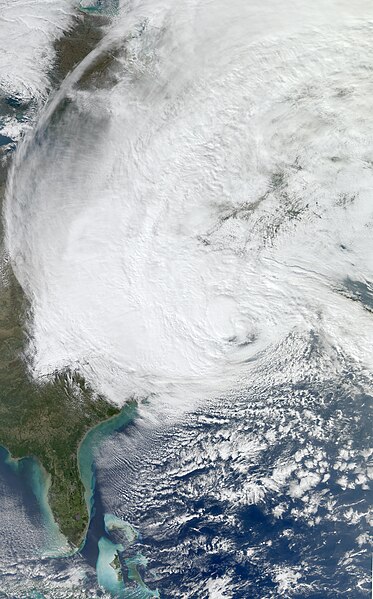
English: The Moderate Resolution Imaging Spectroradiometer (MODIS) on NASA’s Aqua satellite acquired this image of Hurricane Sandy at 2:20 p.m. Eastern Daylight Time (18:20 Universal Time) on October 29, 2012.
At 2:00 p.m. Eastern Daylight Time on October 29, the U.S. National Hurricane Center (NHC) reported that Hurricane Sandy was located about 110 miles (180 kilometers) southeast of Atlantic City, New Jersey, and about 175 miles (285 kilometers) south-southeast of New York City. The storm had maximum sustained winds of 90 miles (150 kilometers) per hour. The storm was moving toward the northwest at about 28 miles (44 kilometers) per hour. The NHC stated that Sandy could change into a wintertime low-pressure system later in the day, but cautioned that this would not weaken the storm prior to landfall. The NHC forecast that Hurricane Sandy would come ashore on the evening of October 29, along the coast of southern New Jersey or Delaware. The NHC warned of multiple hazards associated with the storm. Hurricane-force winds were predicted for the Mid-Atlantic States, including New York City, with tropical storm-force winds from Virginia to Canada. A storm surge, combined with astronomically high tides (at full Moon), promised to flood coastal areas with waters as much as 11 feet (3 meters) above normal. Sandy was forecast to drop as much as 8 inches (20 centimeters) of rain, and the mountains of Appalachia were expected to receive up to 3 feet (1 meter) of snow. The NHC urged potentially affected residents to consult their local National Weather Service forecast offices for more information. Government officials urged residents to heed evacuation warnings, and hundreds of thousands of people had fled their homes by October 29, CNN reported. More than 100,000 customers in seven states had already lost electrical power. In the days leading up to the storm, as residents stocked up on supplies and utility companies called in reinforcements from across the country, the U.S. Geological Survey deployed more than 150 storm-surge sensors along the Atlantic Coast to monitor Sandy’s effects in real time. |
| التاريخ | |
| المصدر | http://lance-modis.eosdis.nasa.gov/cgi-bin/imagery/realtime.cgi?date=2012303 |
| المؤلف | NASA, MODIS/ LANCE, HDF File Data processed by Supportstorm, Caption by Michon Scott |
| إصدارات أخرى |
.jpg) A cropped version is also available: File:Sandy Oct 29 2012 1815Z cropped.jpg A cropped version is also available: File:Sandy Oct 29 2012 1815Z cropped.jpg |
ترخيص
| يقع هذا العمل في النِّطاق العامّ في الولايات المُتحدة الأمريكيَّة لأَنَّه عملٌ خالِصٌ من إِنتاج وكالة الفضاء الأمريكيَّة. تنصُ حقوق التَّأليف والنَّشر الخاصَّة بوكالة الفضاء الأمريكيَّة على أنَّ "أعمال الوكالة غير مَحميَّة بحقوق التَّأليف والنَّشر ما لم يُذكر خلافُ ذلك". لمزيدٍ من المعلومات انظر القالِب {{PD-USGov}} وصفحة حقوق التَّأليف والنَّشر الخاصَّة بالوكالة وصفحة سياسة الصُّور الخاصَّة بمُختبر الدَّفع النَّفَّاث. | ||
 |
تنبيهات:
|
تاريخ الملف
اضغط على زمن/تاريخ لرؤية الملف كما بدا في هذا الزمن.
| زمن/تاريخ | صورة مصغرة | الأبعاد | مستخدم | تعليق | |
|---|---|---|---|---|---|
| حالي | 01:41، 30 أكتوبر 2012 | | 11٬202 × 18٬000 (67٫73 ميجابايت) | Supportstorm | {{Information |Description ={{en|1=At 2:00 p.m. Eastern Daylight Time on October 29, the U.S. National Hurricane Center (NHC) reported that Hurricane Sandy was located about 110 miles (180 kilometers) southeast of Atlantic City, New Jersey, and abou... |
استخدام الملف
الصفحة التالية تستخدم هذا الملف:
الاستخدام العالمي للملف
الويكيات الأخرى التالية تستخدم هذا الملف:
- الاستخدام في az.wikipedia.org
- الاستخدام في ca.wikipedia.org
- الاستخدام في cy.wikipedia.org
- الاستخدام في de.wikipedia.org
- الاستخدام في en.wikipedia.org
- Chris Christie
- Lorenzo Langford
- Bounty (1960 ship)
- Hurricane Sandy
- Effects of Hurricane Sandy in New Jersey
- Effects of Hurricane Sandy in New York
- Effects of Hurricane Sandy in the Greater Antilles
- Template:Hurricane Sandy series
- Effects of Hurricane Sandy in New England
- Meteorological history of Hurricane Sandy
- Effects of Hurricane Sandy in Canada
- Effects of Hurricane Sandy in Maryland and Washington, D.C.
- John B. Caddell
- Hurricane Sandy: Coming Together
- Political impact of Hurricane Sandy
- Occupy Sandy
- 12-12-12: The Concert for Sandy Relief
- 2012–13 North American winter
- 14th Street Tunnel shutdown
- الاستخدام في gl.wikipedia.org
- الاستخدام في mr.wikipedia.org
- الاستخدام في no.wikipedia.org
- الاستخدام في pt.wikipedia.org
- الاستخدام في tr.wikipedia.org