
ملف:Tabaqah assad.jpg
حجم هذه المعاينة: 592 × 600 بكسل. البعدان الآخران: 237 × 240 بكسل | 631 × 639 بكسل.
الملف الأصلي (631 × 639 بكسل حجم الملف: 236 كيلوبايت، نوع MIME: image/jpeg)
| هذا ملف من ويكيميديا كومنز. معلومات من صفحة وصفه مبينة في الأسفل. كومنز مستودع ملفات ميديا ذو رخصة حرة. |
ملخص
| الوصف |
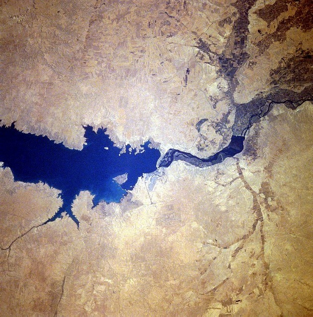
سد الفرات وبحيرة الأسد من الفضاء كانون الثاني 1996 English: Completed in 1973, the Tabaqah Dam (center of image) on the Euphrates River can be seen in this near-nadir view. The Tabaqah Dam is an earth filled dam nearly 197 feet (60 meters) high and 3 miles (5 km) long. The dam holds the waters of Lake Assad (center to left center of the image), a 50-mile (80 km) long and 5-mile (8 km) wide reservoir. Lake Assad and the Tabaqah Dam have not only provided increased hydroelectric power but the lake has doubled Syria’s irrigated land. Actual crop production has not reached the goals set by the Syrian government due to a number of problems including the gypsum subsoil of the region, and whether or not farmers could be attracted back to this scarsely populated area from urban areas or more crowded agricultural areas in other parts of the country. Also the water levels within Lake Assad remain low due mostly in part to construction of the Keban and Ataturk Dams in Turkey, which have reduced the water flow of the Euphrates River in Syria. |
| التاريخ | |
| المصدر | http://eol.jsc.nasa.gov/sseop/EFS/photoinfo.pl?PHOTO=STS078-740-83 , http://upload.wikimedia.org/wikipedia/en/c/cf/Tabaqah_assad.jpg |
| المؤلف | NASA |
فُهرِست هذه الصُّورة أَو هذا التَّسجيل المرئي لدى وهو أحد المراكز التَّابعة لوكالة الفضاء الأَمريكيَّة (ناسا) تحت المُعرِّف STS078-740-83. لا يُشير هذه الوَسم إلى حالة حقوق التَّأليف والنَّشر الخاصَّة بالعمل المُرفَق؛ لا يزال وَسم حقوق التَّأليف والنَّشر مَطلُوباً، راجع كومنز:ترخيص لمزيدٍ من المعلومات. لغات أخرى:
|
ترخيص
| يقع هذا العمل في النِّطاق العامّ في الولايات المُتحدة الأمريكيَّة لأَنَّه عملٌ خالِصٌ من إِنتاج وكالة الفضاء الأمريكيَّة. تنصُ حقوق التَّأليف والنَّشر الخاصَّة بوكالة الفضاء الأمريكيَّة على أنَّ "أعمال الوكالة غير مَحميَّة بحقوق التَّأليف والنَّشر ما لم يُذكر خلافُ ذلك". لمزيدٍ من المعلومات انظر القالِب {{PD-USGov}} وصفحة حقوق التَّأليف والنَّشر الخاصَّة بالوكالة وصفحة سياسة الصُّور الخاصَّة بمُختبر الدَّفع النَّفَّاث. | ||
 |
تنبيهات:
|
تاريخ الملف
اضغط على زمن/تاريخ لرؤية الملف كما بدا في هذا الزمن.
| زمن/تاريخ | صورة مصغرة | الأبعاد | مستخدم | تعليق | |
|---|---|---|---|---|---|
| حالي | 08:45، 3 فبراير 2010 | | 631 × 639 (236 كيلوبايت) | Rehman | Flipped to align according to directions |
| 21:09، 28 أكتوبر 2007 |  | 631 × 639 (200 كيلوبايت) | Amir syria | {{Information |Description=سد الفرات |Source=http://eol.jsc.nasa.gov/sseop/EFS/photoinfo.pl?PHOTO=STS078-740-83 , http://upload.wikimedia.org/wikipedia/en/c/cf/Tabaqah_assad.jpg |Date= |Author= |Permission= |other_versions= }} |
استخدام الملف
الصفحة التالية تستخدم هذا الملف:
الاستخدام العالمي للملف
الويكيات الأخرى التالية تستخدم هذا الملف:
- الاستخدام في arz.wikipedia.org
- الاستخدام في be.wikipedia.org
- الاستخدام في bn.wikipedia.org
- الاستخدام في ca.wikipedia.org
- الاستخدام في ceb.wikipedia.org
- الاستخدام في de.wikipedia.org
- الاستخدام في en.wikipedia.org
- الاستخدام في es.wikipedia.org
- الاستخدام في fa.wikipedia.org
- الاستخدام في fr.wikipedia.org
- الاستخدام في he.wikipedia.org
- الاستخدام في hy.wikipedia.org
- الاستخدام في id.wikipedia.org
- الاستخدام في it.wikipedia.org
- الاستخدام في ko.wikipedia.org
- الاستخدام في lt.wikipedia.org
- الاستخدام في nl.wikipedia.org
- الاستخدام في nn.wikipedia.org
- الاستخدام في no.wikipedia.org
- الاستخدام في pl.wikipedia.org
- الاستخدام في pt.wikipedia.org
- الاستخدام في ro.wikipedia.org
- الاستخدام في ru.wikipedia.org
- الاستخدام في sv.wikipedia.org
اعرض المزيد من الاستخدام العام لهذا الملف.