
ملف:UNOSAT GazaStrip Damage Review 19Feb09 v3 Lowres.png
الملف الأصلي (2٬481 × 3٬509 بكسل حجم الملف: 4٫54 ميجابايت، نوع MIME: image/png)
| هذا ملف من ويكيميديا كومنز. معلومات من صفحة وصفه مبينة في الأسفل. كومنز مستودع ملفات ميديا ذو رخصة حرة. |
ملخص
| الوصف |
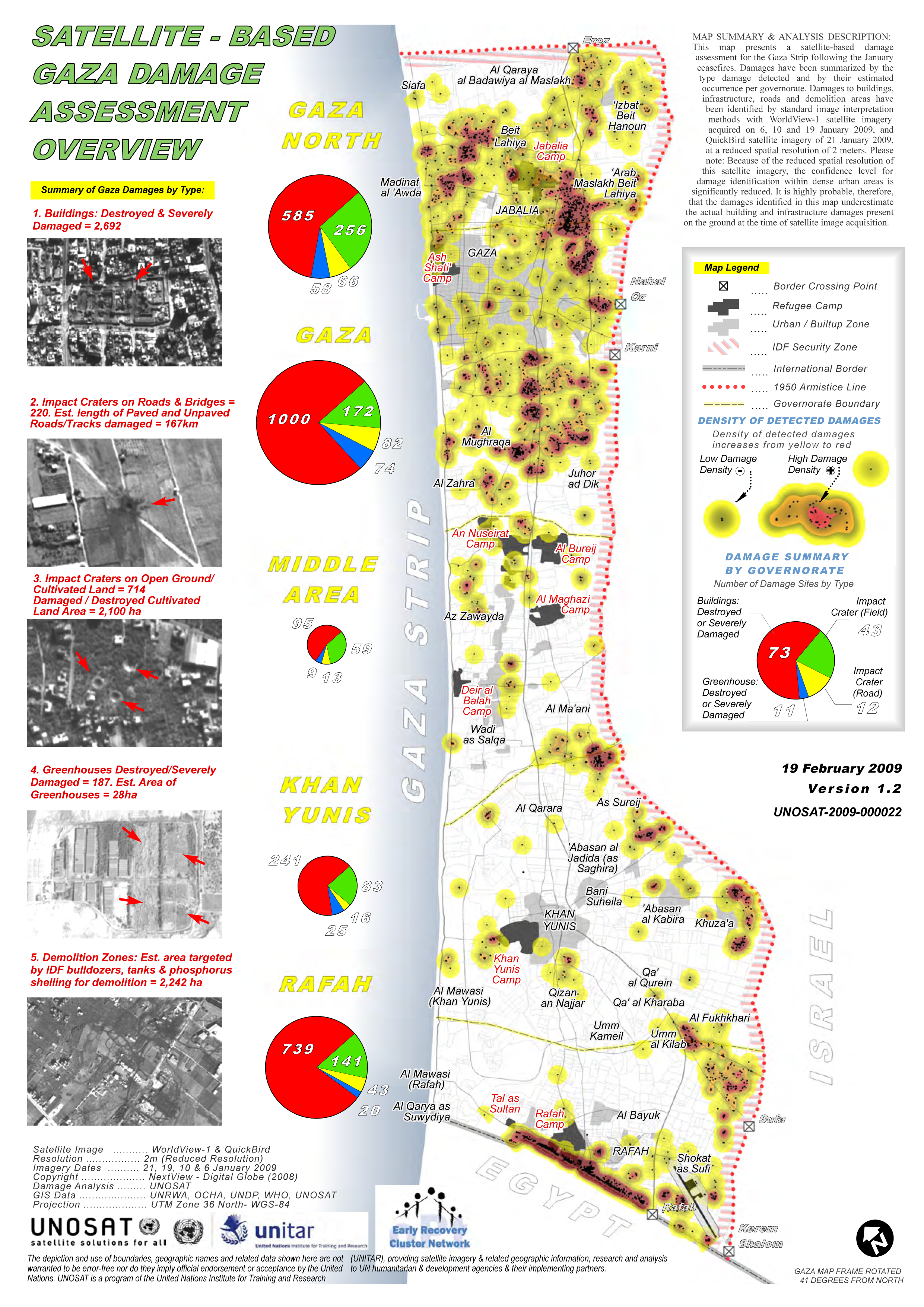
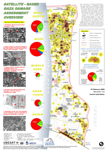
English: From UNOSAT site http://unosat.web.cern.ch/unosat/ Satellite-Based Gaza Strip Damage Assessment Overview
Product ID: 1338 - 10 Mar, 2009 - English This map presents a satellite-based damage assessment for the Gaza Strip following the January ceasefires. Damages have been summarized by the type damage detected and by their estimated occurrence per governorate. Damages to buildings, infrastructure, roads and demolition areas have been identified by standard image interpretation methods with WorldView-1 satellite imagery acquired on 6, 10 and 19 January 2009, and QuickBird satellite imagery of 21 January 2009, at a reduced spatial resolution of 2 meters. Please note: Because of the reduced spatial resolution of this satellite imagery, the confidence level for damage identification within dense urban areas is significantly reduced. It is highly probable, therefore, that the damages identified in this map underestimate the actual building and infrastructure damages present on the ground at the time of satellite image acquisition. Source(s): Satellite Image: WorldView-1 & QuickBird Resolution: 2m (Reduced Resolution) Imagery Dates: 21, 19, 10 & 6 January 2009 Copyright: NextView - Digital Globe (2008) Damage Analysis: UNOSAT GIS Data: UNRWA, OCHA, UNDP, WHO, UNOSAT Note: A test conversion from PDF to SVG using Inkscape produced errors. Arrows indicating bomb craters etc were handed as text but converted to F chars. |
| التاريخ | |
| المصدر | UNOSAT - United Nations |
| المؤلف | Sean.hoyland via PDF to PNG conversion |
| الترخيص (إعادة استخدام هذا الملف) |
"produced or facilitated by UNOSAT for the humanitarian community from public sources. We ask you to kindly credit UNOSAT and/or the original source if this information is used in a report, project etc." |
ترخيص
| This image is a map derived from a United Nations map.
Unless stated otherwise, UN maps are to be considered in the public domain. This applies worldwide. UN maps are, in principle, open source material and you can use them in your work or for making your own map. UN requests however that you delete the UN name, logo and reference number upon any modification to the map. Content of your map will be your responsibility. You can state in your publication, if you wish, something like: based on UN map … (map name, map number, revision number and date). See: Geospatial Information Section. And: Geospatial, location data for a better world. |
 |

|
يَسمَح حامل حقوق هذا الملف لأيٍّ كان باستخدامه لأيِّ غرضٍ، بشرط نسبة المُصنَّف إِلى حامِل الحقوق بشكلٍ سليمٍ. إِنَّ إعادة التوزيع واشتقاق أعمال أخرى مِن هذا الأَصل والاستعمال التِّجاريُّ والاستعمالات الأُخرى جميعها مَسمُوحة. |
|
|
تاريخ الملف
اضغط على زمن/تاريخ لرؤية الملف كما بدا في هذا الزمن.
| زمن/تاريخ | صورة مصغرة | الأبعاد | مستخدم | تعليق | |
|---|---|---|---|---|---|
| حالي | 02:10، 8 أبريل 2009 | | 2٬481 × 3٬509 (4٫54 ميجابايت) | Sean.hoyland | {{Information |Description={{en|1=Satellite-Based Gaza Strip Damage Assessment Overview Product ID: 1338 - 10 Mar, 2009 - English This map presents a satellite-based damage assessment for the Gaza Strip following the January ceasefires. Damages have been |
استخدام الملف
الصفحتان التاليتان تستخدمان هذا الملف:
الاستخدام العالمي للملف
الويكيات الأخرى التالية تستخدم هذا الملف:
- الاستخدام في azb.wikipedia.org
- الاستخدام في en.wikipedia.org
- الاستخدام في fa.wikipedia.org
- الاستخدام في he.wikipedia.org
- الاستخدام في pt.wikipedia.org