
ملف:US Secession map 1863 (BlankMap derived).png

حجم هذه المعاينة: 800 × 488 بكسل. الأبعاد الأخرى: 320 × 195 بكسل | 640 × 390 بكسل | 841 × 513 بكسل.
الملف الأصلي (841 × 513 بكسل حجم الملف: 24 كيلوبايت، نوع MIME: image/png)
| هذا ملف من ويكيميديا كومنز. معلومات من صفحة وصفه مبينة في الأسفل. كومنز مستودع ملفات ميديا ذو رخصة حرة. |
.png)

|
هذه locator map الصورة / الصورتان باستعمال رسومات متجهية ملفات رسوميات شعاعية.
It is recommended to name the SVG file "US Secession map 1863 (BlankMap derived).svg" - then the template Vector version available (or Vva) does not need the new image name parameter.
|
ملخص
| الوصف |
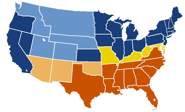
English: United States map of 1863, show affiliation of states and territories regarding the Secession War (Civil War.) Legend:
Union states Union territories not permitting slavery Border Union states, permitting slavery Confederate states Union territories permitting slavery (claimed by Confederacy) |
| التاريخ | تاريخ الرفع الأصيل: 19:04, 24 February 2007 |
| المصدر |
|
| المؤلف | w:en:Porsche997SBS (نقاش | مساهمات) |
ترخيص
This map was obtained from an edition of the National Atlas of the United States. Like almost all works of the U.S. federal government, works from the National Atlas are in the public domain in the United States.
Online access: NationalAtlas.gov | 1970 print edition: Library of Congress, Perry-Castañeda Library
|
سجلُّ الرَّفع الأصيل
| date/time | username | resolution | size | edit summary |
|---|---|---|---|---|
| 19:04, 24 February 2007 | w:en:User:Porsche997SBS | 841×513 | 24 KB | trimming blankness |
| 18:59, 24 February 2007 | w:en:User:Porsche997SBS | 841×580 | 25 KB | don't need that |
| 18:55, 24 February 2007 | w:en:User:Porsche997SBS | 841×580 | 29 KB | format based on [http://en.wikipedia.org/wiki/Image:BlankMap-USA-states.PNG this image]; information from [http://en.wikipedia.org/wiki/Image:US_Secession_map_1865.svg this image]; see description pages there |
Image description page history
| link | date/time | username | edit summary |
|---|---|---|---|
| http://en.wikipedia.org/w/index.php?title=Image:US_Secession_map_1865_(BlankMap_derived).PNG&redirect=no&oldid=110635613 | 07:40, 10 September 2007 | w:en:User:Dmcdevit | |
| http://en.wikipedia.org/w/index.php?title=Image:US_Secession_map_1865_(BlankMap_derived).PNG&redirect=no&oldid=110635613 | 19:02, 24 February 2007 | w:en:User:Porsche997SBS | |
| http://en.wikipedia.org/w/index.php?title=Image:US_Secession_map_1865_(BlankMap_derived).PNG&redirect=no&oldid=110634272 | 18:55, 24 February 2007 | w:en:User:Porsche997SBS | (format based on [http://en.wikipedia.org/wiki/Image:BlankMap-USA-states.PNG this image]; information from [http://en.wikipedia.org/wiki/Image:US_Secession_map_1865.svg this image]; see description pages there) |
.PNG&redirect=no&oldid=110635613)
.PNG&redirect=no&oldid=110634272)
تاريخ الملف
اضغط على زمن/تاريخ لرؤية الملف كما بدا في هذا الزمن.
| زمن/تاريخ | صورة مصغرة | الأبعاد | مستخدم | تعليق | |
|---|---|---|---|---|---|
| حالي | 21:08، 14 يناير 2010 | | 841 × 513 (24 كيلوبايت) | Porsche997SBS | Reverted to version as of 09:03, 14 January 2010--so frustrating |
| 21:07، 14 يناير 2010 |  | 841 × 513 (12 كيلوبايت) | Porsche997SBS | let's try again | |
| 09:03، 14 يناير 2010 |  | 841 × 513 (24 كيلوبايت) | Porsche997SBS | upload error? | |
| 08:52، 14 يناير 2010 |  | 841 × 513 (24 كيلوبايت) | Porsche997SBS | fixing Nebraska, Dakota, and Washington territories and the border between Nevada and Utah | |
| 07:56، 14 يناير 2010 |  | 841 × 513 (24 كيلوبايت) | Porsche997SBS | gray to blue | |
| 08:32، 29 ديسمبر 2007 |  | 841 × 513 (24 كيلوبايت) | Porsche997SBS | updating red to grey | |
| 16:45، 13 سبتمبر 2007 |  | 841 × 513 (24 كيلوبايت) | BetacommandBot | Transwiki approved by: w:en:User:Dmcdevit This image was copied from wikipedia:en. The original description was: format based on [http://en.wikipedia.org/wiki/Image:BlankMap-USA-states.PNG this image]; information from [http://en.wikipedia.org/wiki/ |
استخدام الملف
الصفحة التالية تستخدم هذا الملف:
الاستخدام العالمي للملف
الويكيات الأخرى التالية تستخدم هذا الملف:
- الاستخدام في anp.wikipedia.org
- الاستخدام في azb.wikipedia.org
- الاستخدام في cs.wikipedia.org
- الاستخدام في eml.wikipedia.org
- الاستخدام في en.wikipedia.org
- الاستخدام في eo.wikipedia.org
- الاستخدام في he.wikipedia.org
- الاستخدام في hi.wikipedia.org
- الاستخدام في hu.wikipedia.org
- الاستخدام في hy.wikipedia.org
- الاستخدام في ja.wikipedia.org
- الاستخدام في kk.wikipedia.org
- الاستخدام في kn.wikipedia.org
- الاستخدام في ko.wikipedia.org
- الاستخدام في la.wikipedia.org
- الاستخدام في lt.wikipedia.org
- الاستخدام في ml.wikipedia.org
- الاستخدام في pt.wikipedia.org
- الاستخدام في ru.wikipedia.org
- الاستخدام في si.wikipedia.org
- الاستخدام في sk.wikipedia.org
- الاستخدام في th.wikipedia.org
- الاستخدام في vi.wikipedia.org
.png)