
ملف:A map of the countries between Constantinople and Calcutta including Turkey in Asia, Persia, Afghanistan and Turkestan (cropped-Ahsa region).tif

حجم معاينة JPG لذلك الملف ذي الامتداد TIF: 359 × 600 بكسل. الأبعاد الأخرى: 143 × 240 بكسل | 287 × 480 بكسل | 749 × 1٬251 بكسل.
الملف الأصلي (749 × 1٬251 بكسل حجم الملف: 2٫71 ميجابايت، نوع MIME: image/tiff)
| هذا ملف من ويكيميديا كومنز. معلومات من صفحة وصفه مبينة في الأسفل. كومنز مستودع ملفات ميديا ذو رخصة حرة. |
ملخص
| الوصف |
English: International boundaries, railways, steamship routes, submarine telegraph lines, and British and Russian spheres of influence in Persia as of 1912 |
||
| التاريخ | |||
| المصدر |
|
||
| المؤلف |
Contributor Names Edward Stanford Ltd. Created / Published London : Edward Stanford, 1912. |
||
| إصدارات أخرى |


ترخيص
|
هذا العمل يقع في النَّطاق العامّ في بلد المنشأ وفي البلدان الأخرى والمناطق التي تمتدُّ فيها مدة حقوق التَّأليف والنشر لتغطي زمن حياة المُؤلِّف و 70 سنةً بعد وفاته أو أقل من ذلك. يقع هذ العمل في النَّطاق العامِّ في الولايات المُتحدة الأمريكيَّة لأنَّه نُشِرَ (أو سُجِّل لدى مكتب الولايات المُتحدة لحقوق التَّأليف والنَّشر) قبل ١ يناير ١٩٢٩. | |
| هذا الملفُّ مَلحُوظُ بصفته غيرَ مُقيَّدٍ بحقوق التَّأليف والنشر، وهذا يشمل أيضاً الحقوق المُجاوِرة أَو ذات الصلة جميعُها. | |
| الشروح | هذه الصورة مشروحة: أظهر الشروح في كومنز |
تاريخ الملف
اضغط على زمن/تاريخ لرؤية الملف كما بدا في هذا الزمن.
| زمن/تاريخ | صورة مصغرة | الأبعاد | مستخدم | تعليق | |
|---|---|---|---|---|---|
| حالي | 02:35، 22 نوفمبر 2020 | 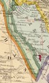 | 749 × 1٬251 (2٫71 ميجابايت) | Ruwaym | File:A map of the countries between Constantinople and Calcutta including Turkey in Asia, Persia, Afghanistan and Turkestan.tif cropped 94 % horizontally, 85 % vertically using CropTool with precise mode. |
استخدام الملف
لا توجد صفحات تستخدم هذا الملف.