
ملف:Covent Garden from the Ralph Agas 1572 map of London - marked.jpg
حجم هذه المعاينة: 800 × 536 بكسل. الأبعاد الأخرى: 320 × 214 بكسل | 640 × 429 بكسل | 821 × 550 بكسل.
الملف الأصلي (821 × 550 بكسل حجم الملف: 524 كيلوبايت، نوع MIME: image/jpeg)
| هذا ملف من ويكيميديا كومنز. معلومات من صفحة وصفه مبينة في الأسفل. كومنز مستودع ملفات ميديا ذو رخصة حرة. |
| الوصف |
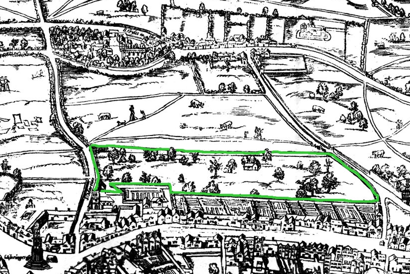
Small detail of the Ralph Agas London map of 1572. Modern marks in green of streets, and in yellow of Covent Garden wall. English: The earliest proper map (as opposed to panorama) of London known. Attributed to Ralph Agas, and probably surveyed between 1570 and 1605. The original was 6 foot 0.5 inches long by 2 feet 4.5 inches wide. This much reduced image is a scan of a copy of a lithograph of a copy, was itself badly repaired with sellotape and has had to be "restored"; so is hardly a truly faithful representation of the original, but few good copies exist and no other detailed public domain images are known. |
| التاريخ | (UTC) |
| المصدر | |
| المؤلف |
|
| هذا رسمٌ مُعَدَّلٌ رقميَّاً من النسخة الأصليَّة. التعديلات هي: Covent Garden marked in green. يُمكن الاطلاع على النسخة الأصليَّة هنا: Covent Garden from the Ralph Agas 1572 map of London.jpg:
|
|
يرتكز هذا العمل المُشتق على أصلٍ مَوجُودٍ في النِّطاق العام، وقد حُسِّن الأصل أو عُدِّل رقميَّاً. إنَّ العمل المُشتق في النِّطاق العام أيضاً بناءً على رغبة مؤلفه. [[:c:User:{{{1}}}|{{{1}}}]]. يسري هذا الإجراء عالمياً.
|
سجلُّ الرَّفع الأصيل
This image is a derivative work of the following images:
- File:Covent_Garden_from_the_Ralph_Agas_1572_map_of_London.jpg licensed with PD-self
- 2010-08-12T18:15:34Z SilkTork 821x550 (545301 Bytes) {{Information |Description=Small detail of the Ralph Agas London map of 1572. Modern marks in green of streets, and in yellow of Covent Garden wall. {{en|1=The earliest proper map (as opposed to panorama) of London known. A
Uploaded with derivativeFX
تاريخ الملف
اضغط على زمن/تاريخ لرؤية الملف كما بدا في هذا الزمن.
| زمن/تاريخ | صورة مصغرة | الأبعاد | مستخدم | تعليق | |
|---|---|---|---|---|---|
| حالي | 07:35، 23 أغسطس 2010 | | 821 × 550 (524 كيلوبايت) | SilkTork | {{Information |Description=Small detail of the Ralph Agas London map of 1572. Modern marks in green of streets, and in yellow of Covent Garden wall. {{en|1=The earliest proper map (as opposed to panorama) of London known. Attributed to Ralph Agas, and p |
استخدام الملف
الصفحة التالية تستخدم هذا الملف:
الاستخدام العالمي للملف
الويكيات الأخرى التالية تستخدم هذا الملف:
- الاستخدام في azb.wikipedia.org
- الاستخدام في en.wikipedia.org
- الاستخدام في ja.wikipedia.org
- الاستخدام في pt.wikipedia.org
- الاستخدام في ru.wikipedia.org
- الاستخدام في vi.wikipedia.org
- الاستخدام في zh.wikipedia.org